Talmage, Kansas
| Talmage, Kansas | |
|---|---|
| Census-designated place | |
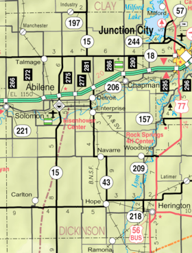 KDOT map of Dickinson County (legend) | |
 Talmage | |
| Coordinates: 39°1′30″N 97°15′38″W / 39.02500°N 97.26056°WCoordinates: 39°1′30″N 97°15′38″W / 39.02500°N 97.26056°W[1] | |
| Country | United States |
| State | Kansas |
| County | Dickinson |
| Area | |
| • Total | 0.10 sq mi (0.25 km2) |
| • Land | 0.10 sq mi (0.25 km2) |
| • Water | 0.0 sq mi (0.0 km2) |
| Elevation[1] | 1,211 ft (369 m) |
| Population (2010) | |
| • Total | 99 |
| • Density | 1,000/sq mi (400/km2) |
| Time zone | UTC-6 (CST) |
| • Summer (DST) | UTC-5 (CDT) |
| Area code | 785 |
| FIPS code | 20-69925 [1] |
| GNIS feature ID | 476481 [1] |
Talmage is a small unincorporated community and census-designated place in Dickinson County, Kansas, United States.[1] As of the 2010 census it had a population of 99.[2]
History
In 1887, Atchison, Topeka and Santa Fe Railway built a branch line from Neva (3 miles west of Strong City) through Talmage to Superior, Nebraska. In 1996, the Atchison, Topeka and Santa Fe Railway merged with Burlington Northern Railroad and renamed to the current BNSF Railway. Most locals still refer to this railroad as the "Santa Fe".
The post office was established December 22, 1887.[3]
Geography
Talmage is located in northwestern Dickinson County, just south of state highway K-18 in the valley of Mud Creek. Via K-18 and K-15, the county seat of Abilene is 11 miles (18 km) to the southeast.
According to the U.S. Census Bureau, Talmage has an area of 0.10 square miles (0.25 km2), all of it land.[2]
Further reading
References
- 1 2 3 4 5 Geographic Names Information System (GNIS) details for Talmage, Kansas; United States Geological Survey (USGS); October 13, 1978.
- 1 2 "Geographic Identifiers: 2010 Demographic Profile Data (G001): Talmage CDP, Kansas". U.S. Census Bureau, American Factfinder. Retrieved October 26, 2015.
- ↑ "Kansas Post Offices, 1828-1961, page 2 (archived)". Kansas Historical Society. Archived from the original on September 9, 2013. Retrieved 8 June 2014.
External links
| Wikimedia Commons has media related to Talmage, Kansas. |
- Photos-Talmage, Dickinson County, Kansas-Wichita State University Libraries
- Dickinson County Maps: Current, Historic, KDOT
Municipalities and communities of Dickinson County, Kansas, United States | ||
|---|---|---|
| Cities | 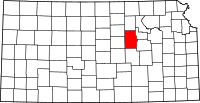 | |
| CDPs | ||
| Unincorporated communities | ||
| Townships | ||
| Footnotes | ‡This populated place also has portions in an adjacent county or counties | |