Elk, Kansas
| Elk, Kansas | |
|---|---|
| Ghost town | |
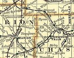 1893 map showing Elk on the border of Chase and Marion Counties | |
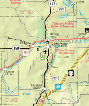 KDOT map of Chase County (legend) | |
 Elk  Elk | |
| Coordinates: 38°24′51″N 96°47′5″W / 38.41417°N 96.78472°WCoordinates: 38°24′51″N 96°47′5″W / 38.41417°N 96.78472°W[1] | |
| Country | United States |
| State | Kansas |
| County | Chase, Marion |
| Population | |
| • Total | 0 |
| Time zone | UTC-6 (CST) |
| • Summer (DST) | UTC-5 (CDT) |
| Area code | 620 |
| GNIS ID | 477253 [1] |
|
| |
Elk was an unincorporated community in Chase and Marion counties in the U.S. state of Kansas.[2] It is currently a ghost town that lays along Middle Creek northwest of Elmdale and straddled the county line between Chase and Marion County.[3][4]
History
Early history
For many millennia, the Great Plains of North America were inhabited by nomadic Native Americans. From the 16th century to 18th century, the Kingdom of France claimed ownership of large parts of North America, including this area. After its defeat in the French and Indian War, France secretly ceded New France to Spain, by the Treaty of Fontainebleau.
19th century
In 1802, Spain returned most of the land to France. In 1803, much of modern day Kansas was acquired by the United States from France as part of the 828,000 square mile Louisiana Purchase at a price of 2.83 cents per acre.
In 1854, the Kansas Territory was organized, and the following year Marion County was established, including portions of Elk. Six years later, Kansas was admitted as a state.[5]
20th century
The community of Elk was founded in the mid 19th century,[6] and it continued to exist into the 1920s.[7] The town had a post office from 1874 until December 1924, when it was replaced by rural free delivery.[8] A post office existed in Elk from August 24, 1874 to December 15, 1924.[9]
21st century
No buildings now remain in Elk, and it is considered a Ghost Town.[10]
Geography
Climate
The climate in this area is characterized by hot, humid summers and generally mild to cool winters. According to the Köppen Climate Classification system, Elk has a humid subtropical climate, abbreviated "Cfa" on climate maps.[11]
See also
- Diamond Creek Township, Chase County, Kansas, east side of Elk
- Grant Township, Marion County, Kansas, west side of Elk
Further reading
References
- 1 2 Geographic Names Information System (GNIS) details for Elk Cemetery; United States Geological Survey (USGS); October 13, 1978.
- ↑ DeLorme. Kansas Atlas & Gazetteer. 4th ed. Yarmouth: DeLorme, 2009, 50. ISBN 0-89933-342-7.; with this map
- ↑ Page 14 from Atlas of the World, 1914.
- ↑ Marion County Kansas : Past and Present; Sondra Van Meter; MB Publishing House; LCCN 72-92041; 344 pages; 1972.
- ↑ The History of Marion County and Courthouse
- ↑ Shown on this 1893 map
- ↑ Shown on this 1921 map
- ↑ University of Nebraska-Lincoln Center for Great Plains Studies, Great Plains Quarterly, vol. 7-8, p. 253
- ↑ "Kansas Post Offices, 1828-1961 (archived)". Kansas Historical Society. Archived from the original on October 9, 2013. Retrieved 5 June 2014.
- ↑ DeLorme. Kansas Atlas & Gazetteer. 4th ed. Yarmouth: DeLorme, 2009, 50. ISBN 0-89933-342-7.
- ↑ Climate Summary for Elk, Kansas
External links
- Historical
- Marion County cemetery list, archive of KsGenWeb
- Marion County history bibliography, Marion County school bibliography, Kansas Historical Society
- Maps
Municipalities and communities of Chase County, Kansas, United States | ||
|---|---|---|
| Cities |  | |
| Unincorporated communities | ||
| Ghost towns | ||
| Townships | ||
| Footnotes | ‡This populated place also has portions in an adjacent county or counties | |
Municipalities and communities of Marion County, Kansas, United States | ||
|---|---|---|
| Cities |  | |
| Unincorporated communities | ||
| Ghost towns | ||
| Townships | ||
| Footnotes | ‡This populated place also has portions in an adjacent county or counties | |