Geary County, Kansas
| Geary County, Kansas | |
|---|---|
| County | |
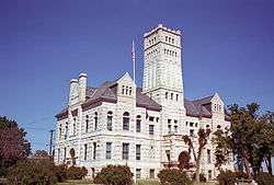 Geary County Courthouse in Junction City | |
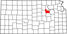 Location in the U.S. state of Kansas | |
 Kansas's location in the U.S. | |
| Founded | 1855 [1] |
| Named for | John W. Geary |
| Seat | Junction City |
| Largest city | Junction City |
| Area | |
| • Total | 404 sq mi (1,046 km2) |
| • Land | 385 sq mi (997 km2) |
| • Water | 20 sq mi (52 km2), 4.9% |
| Population (est.) | |
| • (2016) | 35,586 |
| • Density | 61/sq mi (24/km2) |
| Congressional district | 1st |
| Time zone | Central: UTC−6/−5 |
| Website | gearycounty.org |
Geary County (county code GE) is a county located in the U.S. state of Kansas. As of the 2010 census, the county population was 34,362.[2] Its county seat and most populous city is Junction City.[3] The county is named in honor of Governor John W. Geary.
History
Early history
For many millennia, the Great Plains of North America was inhabited by nomadic Native Americans. From the 16th century to 18th century, the Kingdom of France claimed ownership of large parts of North America. In 1762, after the French and Indian War, France secretly ceded New France to Spain, per the Treaty of Fontainebleau.
19th century
In 1802, Spain returned most of the land to France, but keeping title to about 7,500 square miles. In 1803, most of the land for modern day Kansas was acquired by the United States from France as part of the 828,000 square mile Louisiana Purchase for 2.83 cents per acre.
In 1854, the Kansas Territory was organized, then in 1861 Kansas became the 34th U.S. state. Geary County was formed on August 30, 1855 as an original county from open, free territory. It was among the first 33 counties established by the territory government.
Geary County was originally named Davis County in 1855 after Jefferson Davis (then the United States Secretary of War). During the American Civil War, when Davis became president of the Confederacy, attempts were made to change the county's name, but both failed. Federal and state census records show it as Davis County from 1860 through 1885. In 1888 the county was renamed in honor of John W. Geary, an early Governor of the Kansas Territory.[4][5]
Geography
According to the U.S. Census Bureau, the county has a total area of 404 square miles (1,050 km2), of which 385 square miles (1,000 km2) is land and 20 square miles (52 km2) (4.9%) is water.[6] It is the second-smallest county in Kansas by land area and third-smallest by total area.
Adjacent counties
- Riley County (north)
- Wabaunsee County (east)
- Morris County (south)
- Dickinson County (west)
- Clay County (northwest)
Demographics
| Historical population | |||
|---|---|---|---|
| Census | Pop. | %± | |
| 1860 | 1,163 | — | |
| 1870 | 5,526 | 375.2% | |
| 1880 | 6,994 | 26.6% | |
| 1890 | 10,428 | 49.1% | |
| 1900 | 10,744 | 3.0% | |
| 1910 | 12,681 | 18.0% | |
| 1920 | 13,452 | 6.1% | |
| 1930 | 14,366 | 6.8% | |
| 1940 | 15,222 | 6.0% | |
| 1950 | 21,671 | 42.4% | |
| 1960 | 28,779 | 32.8% | |
| 1970 | 28,111 | −2.3% | |
| 1980 | 29,852 | 6.2% | |
| 1990 | 30,453 | 2.0% | |
| 2000 | 27,947 | −8.2% | |
| 2010 | 34,362 | 23.0% | |
| Est. 2016 | 35,586 | [7] | 3.6% |
| U.S. Decennial Census[8] 1790-1960[9] 1900-1990[10] 1990-2000[11] 2010-2016[2] | |||
Geary County comprises the Junction City, KS Micropolitan Statistical Area, which is included in the Manhattan-Junction City, KS Combined Statistical Area.
As of the 2000 census,[12] there were 27,947 people, 10,458 households, and 7,582 families residing in the county. The population density was 73 people per square mile (28/km²). There were 11,959 housing units at an average density of 31 per square mile (12/km²). The racial makeup of the county was 64.13% White, 22.03% Black or African American, 0.75% Native American, 3.16% Asian, 0.41% Pacific Islander, 4.10% from other races, and 5.41% from two or more races. Hispanic or Latino of any race were 8.45% of the population.
There were 10,458 households out of which 39.60% had children under the age of 18 living with them, 56.90% were married couples living together, 12.30% had a female householder with no husband present, and 27.50% were non-families. 22.50% of all households were made up of individuals and 7.80% had someone living alone who was 65 years of age or older. The average household size was 2.61 and the average family size was 3.07.
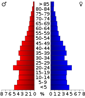
In the county, the population was spread out with 29.60% under the age of 18, 13.60% from 18 to 24, 30.00% from 25 to 44, 17.40% from 45 to 64, and 9.40% who were 65 years of age or older. The median age was 29 years. For every 100 females, there were 97.30 males. For every 100 females age 18 and over, there were 94.30 males.
The median income for a household in the county was $31,917, and the median income for a family was $36,372. Males had a median income of $25,942 versus $21,389 for females. The per capita income for the county was $16,199. About 9.70% of families and 12.10% of the population were below the poverty line, including 16.80% of those under age 18 and 9.90% of those age 65 or over.
Government
Presidential elections
| Year | Republican | Democratic | Third Parties |
|---|---|---|---|
| 2016 | 57.0% 4,274 | 36.3% 2,722 | 6.8% 508 |
| 2012 | 55.7% 4,372 | 42.5% 3,332 | 1.8% 141 |
| 2008 | 55.5% 4,492 | 43.1% 3,491 | 1.4% 111 |
| 2004 | 64.2% 4,703 | 34.5% 2,531 | 1.3% 94 |
| 2000 | 57.9% 3,977 | 38.7% 2,660 | 3.3% 229 |
| 1996 | 54.3% 3,686 | 36.0% 2,444 | 9.7% 660 |
| 1992 | 38.8% 2,928 | 33.9% 2,559 | 27.4% 2,069 |
| 1988 | 57.5% 3,782 | 41.4% 2,721 | 1.1% 70 |
| 1984 | 65.4% 4,464 | 33.7% 2,296 | 0.9% 61 |
| 1980 | 56.1% 3,534 | 37.4% 2,357 | 6.6% 413 |
| 1976 | 52.1% 3,230 | 45.9% 2,843 | 2.0% 123 |
| 1972 | 70.0% 4,299 | 27.8% 1,708 | 2.2% 133 |
| 1968 | 50.7% 2,954 | 38.2% 2,228 | 11.1% 645 |
| 1964 | 39.3% 2,259 | 59.5% 3,419 | 1.2% 67 |
| 1960 | 61.3% 3,789 | 38.3% 2,365 | 0.5% 29 |
| 1956 | 65.5% 4,013 | 33.9% 2,078 | 0.5% 32 |
| 1952 | 70.5% 4,314 | 28.6% 1,750 | 0.9% 52 |
| 1948 | 49.7% 2,864 | 48.8% 2,810 | 1.5% 86 |
| 1944 | 57.0% 2,833 | 42.4% 2,107 | 0.7% 33 |
| 1940 | 52.7% 2,840 | 46.4% 2,504 | 0.9% 50 |
| 1936 | 44.4% 2,382 | 55.4% 2,973 | 0.2% 12 |
| 1932 | 40.9% 1,957 | 56.6% 2,705 | 2.5% 121 |
| 1928 | 69.2% 2,746 | 30.3% 1,203 | 0.6% 22 |
| 1924 | 66.3% 2,678 | 17.9% 723 | 15.8% 636 |
| 1920 | 69.6% 2,404 | 27.8% 962 | 2.6% 90 |
| 1916 | 48.2% 1,731 | 48.5% 1,740 | 3.3% 120 |
| 1912 | 17.4% 387 | 35.9% 800 | 46.7% 1,039 |
| 1908 | 53.4% 1,257 | 43.9% 1,033 | 2.8% 65 |
| 1904 | 67.9% 1,431 | 28.0% 591 | 4.1% 86 |
| 1900 | 54.6% 1,240 | 44.4% 1,009 | 1.1% 24 |
| 1896 | 46.8% 1,051 | 52.1% 1,171 | 1.2% 26 |
| 1892 | 42.7% 863 | 57.3% 1,157 | |
| 1888 | 54.3% 1,027 | 40.0% 756 | 5.7% 107 |
Laws
Geary County was a prohibition, or "dry", county until the Kansas Constitution was amended in 1986 and voters approved the sale of alcoholic liquor by the individual drink with a 30% food sales requirement. The food sales requirement was removed with voter approval in 1990.[14]
Education
Unified school districts
- Geary County USD 475[15]
- Geary is one of the few Kansas counties where a single school district serves the entire county.
Communities
Cities
Unincorporated community
Ghost towns
- Alida, razed when Milford Lake was built
Fort Riley
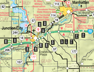
Located north of the junction of the Smoky Hill and Republican rivers, the Fort Riley Military Reservation covers 100,656 acres (407 km2) in Geary and Riley counties. The fort has a daytime population of nearly 25,000 and includes one census-designated place:
- Fort Riley (formerly Fort Riley North), primarily in Riley County
Townships
Geary County is divided into eight townships. The city of Junction City is considered governmentally independent and is excluded from the census figures for the townships. In the following table, the population center is the largest city (or cities) included in that township's population total, if it is of a significant size.
| Township | FIPS | Population center |
Population | Population density /km² (/sq mi) |
Land area km² (sq mi) | Water area km² (sq mi) | Water % | Geographic coordinates |
|---|---|---|---|---|---|---|---|---|
| Blakely | 07275 | 113 | 1 (3) | 93 (36) | 0 (0) | 0.01% | 38°54′32″N 96°45′9″W / 38.90889°N 96.75250°W | |
| Jackson | 34775 | 78 | 1 (2) | 104 (40) | 0 (0) | 0% | 39°1′25″N 96°33′42″W / 39.02361°N 96.56167°W | |
| Jefferson | 35200 | Grandview Plaza | 1,651 | 13 (35) | 124 (48) | 2 (1) | 1.55% | 39°1′53″N 96°46′53″W / 39.03139°N 96.78139°W |
| Liberty | 40050 | 225 | 1 (3) | 171 (66) | 0 (0) | 0.03% | 38°54′53″N 96°36′8″W / 38.91472°N 96.60222°W | |
| Lyon | 43500 | 298 | 3 (7) | 113 (43) | 1 (1) | 1.20% | 38°55′17″N 96°52′3″W / 38.92139°N 96.86750°W | |
| Milford | 46550 | 1,583 | 16 (41) | 101 (39) | 28 (11) | 21.49% | 39°8′59″N 96°54′22″W / 39.14972°N 96.90611°W | |
| Smoky Hill | 66000 | 4,974 | 33 (86) | 149 (58) | 20 (8) | 11.84% | 39°2′14″N 96°53′58″W / 39.03722°N 96.89944°W | |
| Wingfield | 80025 | 139 | 1 (3) | 123 (48) | 0 (0) | 0% | 38°59′38″N 96°38′37″W / 38.99389°N 96.64361°W | |
| Sources: "Census 2000 U.S. Gazetteer Files". U.S. Census Bureau, Geography Division. Archived from the original on 2002-08-02. | ||||||||
See also
|
|
References
- ↑ "Geary County, Kansas Genealogy". Retrieved March 25, 2015.
- 1 2 "State & County QuickFacts". United States Census Bureau. Archived from the original on July 10, 2011. Retrieved July 24, 2014.
- ↑ "Find a County". National Association of Counties. Archived from the original on May 31, 2011. Retrieved 2011-06-07.
- ↑ Cutler, William G. (1883). History of the State of Kansas. A.T. Andreas.
- ↑ Gannett, Henry (1905). The Origin of Certain Place Names in the United States. Govt. Print. Off. p. 135.
- ↑ "US Gazetteer files: 2010, 2000, and 1990". United States Census Bureau. 2011-02-12. Retrieved 2011-04-23.
- ↑ "Population and Housing Unit Estimates". Retrieved June 9, 2017.
- ↑ "U.S. Decennial Census". United States Census Bureau. Archived from the original on May 12, 2015. Retrieved July 24, 2014.
- ↑ "Historical Census Browser". University of Virginia Library. Retrieved July 24, 2014.
- ↑ "Population of Counties by Decennial Census: 1900 to 1990". United States Census Bureau. Retrieved July 24, 2014.
- ↑ "Census 2000 PHC-T-4. Ranking Tables for Counties: 1990 and 2000" (PDF). United States Census Bureau. Retrieved July 24, 2014.
- ↑ "American FactFinder". United States Census Bureau. Archived from the original on September 11, 2013. Retrieved 2008-01-31.
- ↑ Leip, David. "Dave Leip's Atlas of U.S. Presidential Elections". uselectionatlas.org.
- ↑ "Map of Wet and Dry Counties". Alcoholic Beverage Control, Kansas Department of Revenue. November 2006. Archived from the original on October 8, 2007. Retrieved 2007-12-28.
- ↑ "USD 475 – USD 475 – Preparing today's students for tomorrow's world". www.usd475.org.
Further reading
- Standard Atlas of Geary County, Kansas; Geo. A. Ogle & Co; 42 pages; 1909.
External links
| Wikimedia Commons has media related to Geary County, Kansas. |
- County
- Other
- Junction City and Geary County Economic Development
- Geary County Convention and Visitors Bureau
- Fort Riley
- Historical
- Maps
- Geary County Maps: Current, Historic, KDOT
- Kansas Highway Maps: Current, Historic, KDOT
- Kansas Railroad Maps: Current, 1996, 1915, KDOT and Kansas Historical Society
Places adjacent to Geary County, Kansas | ||||||||||
|---|---|---|---|---|---|---|---|---|---|---|
| ||||||||||
Municipalities and communities of Geary County, Kansas, United States | ||
|---|---|---|
| Cities | | |
| CDP | ||
| Unincorporated communities | ||
| Ghost towns | ||
| Townships | ||
| Footnotes | ‡This populated place also has portions in an adjacent county or counties | |
