Arkansas City, Kansas
| Arkansas City, Kansas | |
|---|---|
| City | |
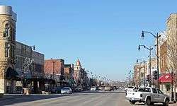 Summit Avenue looking north (2013) | |
| Nickname(s): Ark City | |
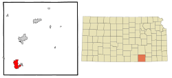 Location within Cowley County and Kansas | |
 KDOT map of Cowley County (legend) | |
| Coordinates: 37°3′55″N 97°2′23″W / 37.06528°N 97.03972°WCoordinates: 37°3′55″N 97°2′23″W / 37.06528°N 97.03972°W | |
| Country | United States |
| State | Kansas |
| County | Cowley |
| Founded | 1870 |
| Area[1] | |
| • Total | 9.38 sq mi (24.29 km2) |
| • Land | 9.36 sq mi (24.24 km2) |
| • Water | 0.02 sq mi (0.05 km2) 0.21% |
| Elevation | 1,119 ft (341 m) |
| Population (2010)[2] | |
| • Total | 12,415 |
| • Estimate (2016)[3] | 12,063 |
| • Density | 1,300/sq mi (510/km2) |
| Time zone | UTC−6 (CST) |
| • Summer (DST) | UTC−5 (CDT) |
| ZIP code | 67005 |
| Area code | 620 |
| FIPS code | 20-02300 [4] |
| GNIS ID | 0470061 [5] |
| Website | arkansascityks.gov |
Arkansas City (/ɑːrˈkænzəs/)[6] is a city in Cowley County, Kansas, United States, situated at the confluence of the Arkansas and Walnut rivers in the southwestern part of the county. As of the 2010 census, the city population was 12,415.[7]
The name of this city is not pronounced like the nearby state of Arkansas, but rather as /ɑːrˈkænzəs/ (the final "s" is pronounced). Over the years there has been much confusion about the regional pronunciation of "Arkansas", which locals render as /ɑːrˈkænzəs/ rather than /ˈɑːrkənsɔː/.[8] Throughout much of Kansas, residents use this alternative pronunciation when referring to the Arkansas River, as well as Arkansas Street in the city of Wichita. Because of this, and for the sake of brevity, Arkansas City is most often referred to as simply Ark City.
History
In 1601, New Mexico Governor Juan de Oñate led an expedition across the Great Plains and found a large settlement of Indians he called Rayados. The most likely location for the Rayado settlement was along the Walnut River in the eastern part of Arkansas City. Extensive remains of Indian settlements have been found along six miles (9.7 km) of the Walnut River. The Rayados were the ancestors of the Indians later called Wichita. Wichita settlements from the 18th century are also found a few miles south of Arkansas City on the west bank of the Arkansas River.[9] (See Deer Creek/Bryson Paddock Sites) Recent archaeological digs conducted by Wichita State University suggest that Arkansas City may be near or on the location of the "lost city" of Etzanoa, occupied by the Rayado Indians in the early 17th century.[10]
19th century
White settlers first congregated in the area where Arkansas City now stands in the 1860s. The natives referred to the place as "Nichonka", which roughly translates as "place between the waters" — a reference to the confluence of the Arkansas and Walnut rivers.
Settlers established a town in 1870. They had difficulty choosing a name; early names included Adelphia, Creswell, and Walnut City before the present name was chosen.[11] The first post office in Arkansas City was established on May 16, 1870.[12]
In 1877, the Florence, El Dorado, and Walnut Valley Railroad Company built a branch line from Florence to El Dorado, in 1881 it was extended to Douglass, and later to Arkansas City.[13] The line was leased and operated by the Atchison, Topeka and Santa Fe Railway. The line from Florence to El Dorado was abandoned in 1942.[14] The original branch line connected Florence, Burns, De Graff, El Dorado, Augusta, Douglass, Rock, Akron, Winfield, Arkansas City.
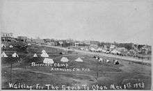
Arkansas City grew steadily through the latter part of the 19th century, and enjoyed a population explosion starting in 1891, when thousands of people moved into the area in anticipation of the Cherokee Strip Land Run. It has been estimated that the city's population swelled from 5,000 to 150,000 (most living in temporary encampments) as the nationally hyped federal land giveaway approached, and shrank back to 5,000 in its aftermath.
A small cave just east of town (in the Flint Hills) was a rest stop for Buffalo Bill Cody when he transited the area working the railroad and killing buffalo.
The James–Younger Gang of outlaws hid out in a cave west of town when they rode through the area.
20th century
At the turn of the century, Arkansas City was a rival to Wichita in size and enterprise, boasting several busy rail lines, an elegant opera house, numerous fine hotels, a manufacturing base and a bustling agricultural economy. There was even a famous sanitarium (health spa) at nearby Geuda Springs. A popular swimming hole called Paris Lake was located west of downtown; the lake – and the hot springs at Geuda as well – was mired with silt in a flood about 1919. Nearly 20 years later the WPA would build the Paris Park pool in the same spot. African Americans were not allowed to swim in the Paris Park pool during the era of segregation and used a separate facility colloquially referred to as "the black pool" by local residents.
The Kirkwood Wind Engine Company, a former windmill manufacturer, was headquartered in Arkansas City near the turn of the 20th century; the now-defunct Kanotex Refining Company established a refinery and headquarters in the city in 1917.[15]
During the 1920s, Arkansas City had an active group of Ku Klux Klan. The group was mostly concentrated in south-central and south-east Kansas. The state took action to shut down the group, and most Klans disbanded by 1927.[16]
In 1928, the city's official fall festival, Arkalalah, was inaugurated. This annual event still draws thousands of visitors each October, and features a queen, a carnival, dozens of homegrown fair food vendors and a spectacular parade typically lasting two hours or more. During the 1955 Arkalalah celebration, retired Santa Fe steam locomotive 2542 was dedicated in Wilson Park, where it remains today.[17]
The city prospered through much of the 20th century, but by the 1980s, the community was facing economic challenges. The railroads shifted many of their crews to other stops, the old Rodeo meat packing plant, which for a short time was Morrell Meats, closed. The only passenger train that served the city, Amtrak's Lone Star, was discontinued. In 1996 Total Petroleum closed their refinery in Ark City with a loss of 170 jobs. By 2003 other large employers in Cowley County closed operations. The Binney & Smith (Crayola) plant closed with a loss of 400 jobs. Winfield State Hospital and Gordon Piatt Industries were closed in nearby Winfield with a combined loss of 973 jobs. Montgomery KONE Elevator and Central Plains Book Manufacturing at nearby Strother Field were also shuttered.
21st century
Arkansas City is now home to state-of-the-art meat processor Creekstone Farms Premium Beef LLC which employs over 700 workers. Several smaller manufacturing companies are expanding their operations while new start ups are finding a home in Cowley County due in part to the workforce supplied by the two local colleges in the county. Both cities, only 11 miles (18 km) apart, now have large Wal-Mart stores (a new Wal-Mart Supercenter opened in Arkansas City in March 2006, and another has been constructed in Winfield); conversely, both towns' (in Arkansas City – the Burford, the Howard, and the Crest) movie theaters recently closed and were replaced by a single facility halfway between the cities, just south of the Strother Field industrial park. B & B Theatres donated the two downtown buildings to non-profit organizations in each of the respective communities. The Ark City Burford Theatre and Commercial Building is undergoing a transformation/renovation that will become a new community arts center and gathering space. Construction began in spring 2006 on the planned downtown revitalization streetscape.
In 2006, the local physicians in Arkansas City banded together with the South Central Kansas Regional Medical Center (SCKRMC) board and the City of Arkansas City to build a new hospital, which opened in March 2011.[18]
In 2010, the Keystone-Cushing Pipeline (Phase II) was constructed west of Arkansas City, north to south through Cowley County, with much controversy over tax exemption and environmental concerns (if a leak ever occurs).[19][20]
Geography
Arkansas City is located at 37°3′55″N 97°2′23″W / 37.06528°N 97.03972°W (37.065267, −97.039608).[21] The city is situated along the northern bank of the Arkansas River and to the west of its confluence with the Walnut River. It is located at the junction of U.S. Route 77 and U.S. Route 166, only four miles (6.4 km) north of the Kansas-Oklahoma border. Winfield, the county seat, is 13 miles (21 km) north of Arkansas City along US-77, and Strother Field, a general aviation airport, is about eight miles (13 km) north. Arkansas City is located 54 miles (87 km) southeast of Wichita.
According to the United States Census Bureau, the city has a total area of 9.38 square miles (24.29 km2), of which 9.36 square miles (24.24 km2) is land and 0.02 square miles (0.05 km2) is water.[1]
Climate
The climate in this area is characterized by hot, humid summers and generally mild to cool winters. According to the Köppen Climate Classification system, Arkansas City has a humid subtropical climate, abbreviated "Cfa" on climate maps.[22]
Demographics
| Historical population | |||
|---|---|---|---|
| Census | Pop. | %± | |
| 1880 | 1,012 | — | |
| 1890 | 8,347 | 724.8% | |
| 1900 | 6,140 | −26.4% | |
| 1910 | 7,508 | 22.3% | |
| 1920 | 11,253 | 49.9% | |
| 1930 | 13,946 | 23.9% | |
| 1940 | 12,752 | −8.6% | |
| 1950 | 12,903 | 1.2% | |
| 1960 | 14,262 | 10.5% | |
| 1970 | 13,216 | −7.3% | |
| 1980 | 13,201 | −0.1% | |
| 1990 | 12,762 | −3.3% | |
| 2000 | 11,963 | −6.3% | |
| 2010 | 12,415 | 3.8% | |
| Est. 2016 | 12,063 | [3] | −2.8% |
| U.S. Decennial Census | |||
2010 census
As of the census[2] of 2010, there were 12,415 people, 4,802 households, and 3,030 families residing in the city. The population density was 1,326.4 inhabitants per square mile (512.1/km2). There were 5,646 housing units at an average density of 603.2 per square mile (232.9/km2). The racial makeup of the city was 79.4% White, 3.9% African American, 2.7% Native American, 0.6% Asian, 0.1% Pacific Islander, 8.7% from other races, and 4.6% from two or more races. Hispanic or Latino of any race were 17.3% of the population.
There were 4,802 households of which 33.8% had children under the age of 18 living with them, 43.4% were married couples living together, 13.9% had a female householder with no husband present, 5.9% had a male householder with no wife present, and 36.9% were non-families. 31.9% of all households were made up of individuals and 13.6% had someone living alone who was 65 years of age or older. The average household size was 2.47 and the average family size was 3.07.
The median age in the city was 33.8 years. 26.4% of residents were under the age of 18; 12.7% were between the ages of 18 and 24; 23.3% were from 25 to 44; 22.7% were from 45 to 64; and 14.8% were 65 years of age or older. The gender makeup of the city was 48.3% male and 51.7% female.
2000 census
As of the census of 2000, there were 11,963 people, 4,855 households, and 3,102 families residing in the city. The population density was 1,592.5 people per square mile (615.0/km²). There were 5,628 housing units at an average density of 749.2 per square mile (289.3/km²). The racial makeup of the city was 87.15% White, 4.51% African American, 2.69% Native American, 0.64% Asian, 0.02% Pacific Islander, 1.95% from other races, and 3.04% from two or more races. Hispanic or Latino of any race were 4.47% of the population.
There were 4,855 households out of which 30.3% had children under the age of 18 living with them, 48.2% were married couples living together, 11.7% had a female householder with no husband present, and 36.1% were non-families. 31.7% of all households were made up of individuals and 14.9% had someone living alone who was 65 years of age or older. The average household size was 2.36 and the average family size was 2.97.
In the city, the population was spread out with 25.7% under the age of 18, 11.2% from 18 to 24, 24.3% from 25 to 44, 20.9% from 45 to 64, and 17.9% who were 65 years of age or older. The median age was 36 years. For every 100 females, there were 88.3 males. For every 100 females age 18 and over, there were 84.8 males.
The median income for a household in the city was $29,158, and the median income for a family was $39,962. Males had a median income of $30,665 versus $19,919 for females. The per capita income for the city was $15,933. About 12.4% of families and 16.4% of the population were below the poverty line, including 20.5% of those under age 18 and 14.5% of those age 65 or over.
Education
Arkansas City Public Schools serves the community.
Cowley College, formerly Cowley County Community College, is located between 1st and 4th streets, and Central and Adams Avenues in Ark City. Cowley is a community college and vocational/technical school with more than 68 majors and degree possibilities. Cowley College celebrates 85 years of innovation and excellence in 2007. (Beginning in 1922 in the basement of Arkansas City High School.) Other campuses include: Aviation Tech Center (Wichita, KS), Allied Health Center (Winfield, KS), Career & Technical Education Center (Mulvane, KS), and Bloomenshine Center (Mulvane, KS). Its primary buildings are the Brown Center Theatre, W.S. Scott Auditorium, Renn-Memorial Library, Kerr Building, Walker Industrial Technology Building, Ben Cleveland Wellness Center, Kerr Building, Galle-Johnson Hall and four separate dormitories: Storbeck, Kirke W. Dale, Docking, and Kimmell. The college also owns one of the old high school buildings (Ireland Hall), which houses its criminal justice and cosmetology classes. The most recent building, Webb-Brown, is located on the Eastern corner of 3rd and Washington, replacing the former Ark City Junior High School.
Media
- The Arkansas City Traveler
- The Winfield Daily Courier for nearby Winfield
Radio
Notable people
- Darren Daulton, baseball player for the Philadelphia Phillies and Florida Marlins
- Frank Davis, American journalist, poet, political and labor movement activist, born in Arkansas City
- Robert Docking, Mayor of Arkansas City, Governor of Kansas, 1967–1975
- Robert Eaton, automobile businessman, grew up in Arkansas City
- Lionel Hollins, former NBA professional basketball player and former head coach of the Brooklyn Nets
- Richard Killblane, author and military historian, born in Arkansas City and attended two years of elementary school.
- Anna Larkin, folk sculptor, lived in Arkansas City upon moving to the United States[23]
- Nila Mack, actress, writer and director, golden age radio program Let's Pretend
- Dick Metz, professional golfer, born in Arkansas City
- Leslie Miller, former professional football player, born in Arkansas City
- Jack Mitchell, football head coach, Arkansas and Kansas, born in Arkansas City
- Billy Mize, musician, born in Arkansas City
- Helen Parsons, biochemist, born in Arkansas City
- Jim Sheets, Republican politician in Arkansas, former executive director of Kiwanis International Foundation
- Euclid Sherwood, commonly known as Motorhead Sherwood, vocalist and saxophonist for The Mothers of Invention during the band's early years
See also
References
- 1 2 "US Gazetteer files 2010". United States Census Bureau. Archived from the original on January 24, 2012. Retrieved 2012-07-06.
- 1 2 "American FactFinder". United States Census Bureau. Retrieved 2012-07-06.
- 1 2 "Population and Housing Unit Estimates". Retrieved June 9, 2017.
- ↑ "American FactFinder". United States Census Bureau. Archived from the original on September 11, 2013. Retrieved 2008-01-31.
- ↑ "US Board on Geographic Names". United States Geological Survey. 2007-10-25. Retrieved 2008-01-31.
- ↑ William Allen White School of Journalism and Public Information (1955). A pronunciation guide to Kansas place names. Lawrence, KS: University of Kansas. p. 7.
- ↑ "2010 City Population and Housing Occupancy Status". U.S. Census Bureau. Archived from the original on July 26, 2011. Retrieved March 6, 2011.
- ↑ Pronunciation Guide
- ↑ Vehik, Susan C. "Onate's Expedition to the Southern Plains: Routes, Destinations, and Implications for Late Prehistoric Cultural Adaptations." Plains Anthropologist, Vol 31, No. 111, 1986, 13–33
- ↑ Kelly, David (August 19, 2018). "Archaeologists explore a rural field in Kansas, and a lost city emerges". Los Angeles Times. Retrieved August 20, 2018.
- ↑ Kansas State Historical Society (1916). Biennial Report of the Board of Directors of the Kansas State Historical Society. Kansas State Printing Plant. p. 168.
- ↑ "Kansas Post Offices, 1828-1961 (archived)". Kansas Historical Society. Archived from the original on October 9, 2013. Retrieved 6 June 2014.
- ↑ Marion County Kansas : Past and Present; Sondra Van Meter; MB Publishing House; LCCN 72-92041; 344 pages; 1972.
- ↑ Railway Abandonment 1942
- ↑ Junge, Aspen (June 30, 2010). "Refining History" (PDF). Kansas Department of Health and Environment. Retrieved May 5, 2012.
- ↑ Kansas Battles the Invisible Empire: The Legal Ouster of the KKK from Kansas during 1922-1927; Kansas State Historical Society; 1974.
- ↑ "Digital Archives of the Arkansas City Public Library". Arkansas City Daily Traveler.
- ↑ Siebenmark, Jerry (March 13, 2011). "New hospital to open in Ark City". The Wichita Eagle. Retrieved June 25, 2011.
- ↑ Keystone Pipeline – Marion County Commission calls out Legislative Leadership on Pipeline Deal; April 18, 2010. Archived October 22, 2011, at the Wayback Machine.
- ↑ Keystone Pipeline – TransCanada inspecting pipeline; December 10, 2010.
- ↑ "US Gazetteer files: 2010, 2000, and 1990". United States Census Bureau. 2011-02-12. Retrieved 2011-04-23.
- ↑ Climate Summary for Arkansas City, Kansas
- ↑ Jules Heller; Nancy G. Heller (19 December 2013). North American Women Artists of the Twentieth Century: A Biographical Dictionary. Routledge. ISBN 978-1-135-63882-5.
Further reading
- County
- History of Cowley County Kansas; D.A. Millington / E.P. Greer; Winfield Courier; 162 pages; 1901. (Download 16MB PDF eBook)
- Standard Atlas of Cowley County, Kansas; Geo. A. Ogle & Co; 54 pages; 1905.
- Edwards' Historical Atlas of Cowley County, Kansas; John P. Edwards; 52 pages; 1882.
- Kansas
- History of the State of Kansas; William G. Cutler; A.T. Andreas Publisher; 1883. (Online HTML eBook)
- Kansas : A Cyclopedia of State History, Embracing Events, Institutions, Industries, Counties, Cities, Towns, Prominent Persons, Etc; 3 Volumes; Frank W. Blackmar; Standard Publishing Co; 944 / 955 / 824 pages; 1912. (Volume1 - Download 54MB PDF eBook), (Volume2 - Download 53MB PDF eBook), (Volume3 - Download 33MB PDF eBook)
External links
| Wikimedia Commons has media related to Arkansas City, Kansas. |
- City
- Media
- The Arkansas City Traveler, Local Newspaper
- KACY Radio, Local Radio Station
- Schools
- USD 470, local school district
- Cowley College
- Maps
- Arkansas City Map, KDOT
- Encyclopedias

Municipalities and communities of Cowley County, Kansas, United States | ||
|---|---|---|
| Cities |  | |
| Unincorporated communities | ||
| Townships | ||
| Footnotes | ‡This populated place also has portions in an adjacent county or counties | |