Labette County, Kansas
| Labette County, Kansas | |
|---|---|
| County | |
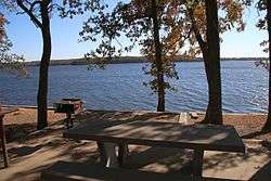 Big Hill Lake in western Labette County | |
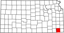 Location in the U.S. state of Kansas | |
 Kansas's location in the U.S. | |
| Founded | February 26, 1867 |
| Named for | Pierre La Bette |
| Seat | Oswego |
| Largest city | Parsons |
| Area | |
| • Total | 653 sq mi (1,691 km2) |
| • Land | 645 sq mi (1,671 km2) |
| • Water | 7.8 sq mi (20 km2), 1.2% |
| Population (est.) | |
| • (2016) | 20,444 |
| • Density | 33/sq mi (13/km2) |
| Congressional district | 2nd |
| Time zone | Central: UTC−6/−5 |
| Website | LabetteCounty.com |
Labette County (county code LB) is a county located in the U.S. state of Kansas. As of the 2010 census, the county population was 21,607.[1] Its county seat is Oswego,[2] and its most populous city is Parsons. The county was named after LaBette creek,[3][4] the second-largest creek in the county, which runs roughly NNW-SSE from near Parsons to Chetopa. The creek in turn was named after French-Canadian fur trapper Pierre LaBette who had moved to the area, living along the Neosho River, and marrying into the Osage tribe in the 1830s and 1840s.[4]
History
In the 1840s Labette County had a population mainly consisting of Osage people, although there were also many Cherokee and Euro-Americans. Many of the Euro-Americans were merchants with Osage or Cherokee wives.[5]
Between 1871 and 1873, at least eleven people vanished in the vicinity of an inn and general store operated by the Bender family in Labette County. Following the disappareance of the Benders in 1873, it was discovered that they had apparently murdered a number of travellers. Between eight and eleven bodies were discovered buried on the premises. Governor Thomas A. Osborn offered a reward of $2,000 for the apprehension of the Benders, but they were never found.[6][7]
Geography
According to the U.S. Census Bureau, the county has a total area of 653 square miles (1,690 km2), of which 645 square miles (1,670 km2) is land and 7.8 square miles (20 km2) (1.2%) is water.[8]
Adjacent counties
- Neosho County (north)
- Crawford County (northeast)
- Cherokee County (east)
- Craig County, Oklahoma (south)
- Nowata County, Oklahoma (southwest)
- Montgomery County (west)
Demographics
| Historical population | |||
|---|---|---|---|
| Census | Pop. | %± | |
| 1870 | 9,973 | — | |
| 1880 | 22,735 | 128.0% | |
| 1890 | 27,586 | 21.3% | |
| 1900 | 27,387 | −0.7% | |
| 1910 | 31,423 | 14.7% | |
| 1920 | 34,047 | 8.4% | |
| 1930 | 31,346 | −7.9% | |
| 1940 | 30,352 | −3.2% | |
| 1950 | 29,285 | −3.5% | |
| 1960 | 26,805 | −8.5% | |
| 1970 | 25,775 | −3.8% | |
| 1980 | 25,682 | −0.4% | |
| 1990 | 23,693 | −7.7% | |
| 2000 | 22,169 | −6.4% | |
| 2010 | 21,607 | −2.5% | |
| Est. 2016 | 20,444 | [9] | −5.4% |
| U.S. Decennial Census[10] 1790-1960[11] 1900-1990[12] 1990-2000[13] 2010-2016[1] | |||
The Parsons, KS Micropolitan Statistical Area includes all of Labette County.
As of the 2010 Census Labette County had a population of 21,607. The median age was 41. The racial and ethnic composition of the population was 85.5% non-Hispanic white, 4.7% African-American, 2.2% Native America, 0.4% Asian, 0.1% non-Hispanics of some other race, 3.6% non-Hispanics reporting two or more races and 4.0% Hispanic or Latino.[14]
As of the 2000 census,[15] there were 22,835 people, 9,194 households, and 6,114 families residing in the county. The population density was 35 people per square mile (14/km2). There were 10,306 housing units at an average density of 16 per square mile (6/km2). The racial makeup of the county was 89.28% White, 4.66% Black or African American, 1.95% Native American, 0.32% Asian, 0.01% Pacific Islander, 1.20% from other races, and 2.58% from two or more races. Hispanic or Latino of any race were 3.07% of the population.
There were 9,194 households out of which 31.20% had children under the age of 18 living with them, 52.10% were married couples living together, 10.20% had a female householder with no husband present, and 33.50% were non-families. 29.80% of all households were made up of individuals and 14.30% had someone living alone who was 65 years of age or older. The average household size was 2.39 and the average family size was 2.95.
In the county, the population was spread out with 25.70% under the age of 18, 8.70% from 18 to 24, 25.80% from 25 to 44, 22.50% from 45 to 64, and 17.30% who were 65 years of age or older. The median age was 38 years. For every 100 females, there were 95.70 males. For every 100 females age 18 and over, there were 92.00 males.
The median income for a household in the county was $30,875, and the median income for a family was $37,519. Males had a median income of $29,043 versus $21,706 for females. The per capita income for the county was $15,525. About 8.90% of families and 12.70% of the population were below the poverty line, including 14.70% of those under age 18 and 11.90% of those age 65 or over.
Government
Presidential elections
| Year | Republican | Democratic | Third Parties |
|---|---|---|---|
| 2016 | 65.8% 5,335 | 28.3% 2,291 | 5.9% 481 |
| 2012 | 59.0% 4,742 | 38.8% 3,117 | 2.2% 178 |
| 2008 | 55.4% 5,001 | 42.5% 3,839 | 2.1% 191 |
| 2004 | 59.1% 5,400 | 39.6% 3,615 | 1.4% 124 |
| 2000 | 52.4% 4,475 | 43.9% 3,745 | 3.7% 318 |
| 1996 | 45.7% 4,283 | 41.9% 3,931 | 12.4% 1,166 |
| 1992 | 33.1% 3,368 | 41.2% 4,196 | 25.7% 2,613 |
| 1988 | 52.9% 5,125 | 45.8% 4,433 | 1.3% 126 |
| 1984 | 63.8% 6,542 | 35.4% 3,631 | 0.9% 87 |
| 1980 | 52.9% 5,244 | 39.8% 3,947 | 7.4% 730 |
| 1976 | 45.6% 4,640 | 52.0% 5,294 | 2.4% 243 |
| 1972 | 64.8% 6,399 | 32.5% 3,210 | 2.8% 272 |
| 1968 | 51.2% 5,503 | 37.0% 3,974 | 11.8% 1,273 |
| 1964 | 43.0% 4,761 | 56.1% 6,208 | 0.8% 93 |
| 1960 | 58.5% 7,491 | 41.0% 5,248 | 0.5% 68 |
| 1956 | 59.4% 7,677 | 40.2% 5,202 | 0.4% 57 |
| 1952 | 62.0% 8,624 | 37.5% 5,219 | 0.5% 70 |
| 1948 | 50.1% 6,298 | 48.7% 6,113 | 1.2% 154 |
| 1944 | 57.9% 7,480 | 41.8% 5,398 | 0.4% 48 |
| 1940 | 54.2% 8,210 | 45.3% 6,860 | 0.6% 87 |
| 1936 | 44.9% 6,610 | 54.7% 8,050 | 0.4% 59 |
| 1932 | 42.1% 5,794 | 55.7% 7,667 | 2.1% 294 |
| 1928 | 74.2% 9,048 | 24.4% 2,969 | 1.4% 174 |
| 1924 | 55.3% 6,593 | 24.9% 2,971 | 19.9% 2,369 |
| 1920 | 57.9% 6,596 | 38.0% 4,328 | 4.0% 460 |
| 1916 | 42.6% 5,328 | 51.4% 6,421 | 6.0% 755 |
| 1912 | 21.9% 1,516 | 37.0% 2,568 | 41.1% 2,853[lower-alpha 1] |
| 1908 | 49.2% 3,367 | 40.6% 2,783 | 10.2% 698 |
| 1904 | 58.7% 3,700 | 26.0% 1,637 | 15.4% 968 |
| 1900 | 48.8% 3,319 | 50.3% 3,425 | 0.9% 61 |
| 1896 | 46.2% 3,206 | 52.9% 3,669 | 0.9% 64 |
| 1892 | 47.9% 2,950 | 52.1% 3,210 | |
| 1888 | 47.4% 2,870 | 16.1% 976 | 36.5% 2,211 |
Laws
Following amendment to the Kansas Constitution in 1986, the county remained a prohibition, or "dry", county until 1996, when voters approved the sale of alcoholic liquor by the individual drink with a 30% food sales requirement.[17]
Education
Unified school districts
- Cherokee USD 247 (Web site) is a school district of 300 square miles (780 km2) primarily covering portions of Crawford and Cherokee counties, but also includes small portions of Labette and Neosho counties.[18]
- Parsons USD 503 (Web site)
- Oswego USD 504 (Web site)
- Chetopa-St. Paul USD 505 (Web site)
- Labette County USD 506 (Web site)
Communities
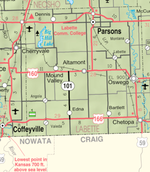
Cities
Unincorporated communities
Townships
Labette County is divided into sixteen townships. The cities of Chetopa, Oswego, and Parsons are considered governmentally independent and are excluded from the census figures for the townships. In the following table, the population center is the largest city (or cities) included in that township's population total, if it is of a significant size.
| Township | FIPS | Population center |
Population | Population density /km2 (/sq mi) |
Land area km2 (sq mi) | Water area km² (sq mi) | Water % | Geographic coordinates |
|---|---|---|---|---|---|---|---|---|
| Canada | 10325 | 217 | 2 (5) | 103 (40) | 0 (0) | 0.22% | 37°6′18″N 95°27′4″W / 37.10500°N 95.45111°W | |
| Elm Grove | 20750 | 798 | 6 (16) | 130 (50) | 0 (0) | 0.17% | 37°3′22″N 95°20′12″W / 37.05611°N 95.33667°W | |
| Fairview | 22550 | 239 | 3 (7) | 94 (36) | 0 (0) | 0.11% | 37°10′9″N 95°12′6″W / 37.16917°N 95.20167°W | |
| Hackberry | 29350 | 403 | 3 (8) | 131 (51) | 0 (0) | 0.15% | 37°3′30″N 95°12′44″W / 37.05833°N 95.21222°W | |
| Howard | 33300 | 357 | 3 (8) | 111 (43) | 0 (0) | 0.13% | 37°2′23″N 95°27′33″W / 37.03972°N 95.45917°W | |
| Labette | 37400 | 373 | 4 (10) | 94 (36) | 0 (0) | 0.18% | 37°15′43″N 95°18′54″W / 37.26194°N 95.31500°W | |
| Liberty | 40175 | 395 | 4 (11) | 95 (37) | 0 (0) | 0.11% | 37°15′47″N 95°11′45″W / 37.26306°N 95.19583°W | |
| Montana | 47850 | 179 | 3 (7) | 71 (27) | 1 (1) | 1.90% | 37°15′28″N 95°7′34″W / 37.25778°N 95.12611°W | |
| Mound Valley | 48850 | 806 | 5 (13) | 166 (64) | 0 (0) | 0.11% | 37°12′30″N 95°25′40″W / 37.20833°N 95.42778°W | |
| Mount Pleasant | 48950 | 1,351 | 14 (37) | 93 (36) | 0 (0) | 0.34% | 37°10′50″N 95°18′14″W / 37.18056°N 95.30389°W | |
| Neosho | 49775 | 222 | 3 (8) | 70 (27) | 2 (1) | 2.40% | 37°20′11″N 95°6′37″W / 37.33639°N 95.11028°W | |
| North | 50975 | 612 | 7 (19) | 83 (32) | 0 (0) | 0.16% | 37°19′39″N 95°12′40″W / 37.32750°N 95.21111°W | |
| Osage | 53150 | 703 | 4 (12) | 157 (61) | 5 (2) | 2.93% | 37°20′4″N 95°26′18″W / 37.33444°N 95.43833°W | |
| Oswego | 53475 | 310 | 5 (12) | 66 (25) | 1 (0) | 1.73% | 37°9′21″N 95°6′22″W / 37.15583°N 95.10611°W | |
| Richland | 59425 | 303 | 3 (8) | 97 (38) | 0 (0) | 0.43% | 37°3′29″N 95°6′19″W / 37.05806°N 95.10528°W | |
| Walton | 75250 | 726 | 9 (23) | 83 (32) | 0 (0) | 0.16% | 37°20′59″N 95°19′2″W / 37.34972°N 95.31722°W | |
| Sources: "Census 2000 U.S. Gazetteer Files". U.S. Census Bureau, Geography Division. Archived from the original on 2002-08-02. | ||||||||
See also
|
|
References
- 1 2 "State & County QuickFacts". United States Census Bureau. Archived from the original on July 13, 2011. Retrieved July 26, 2014.
- ↑ "Find a County". National Association of Counties. Retrieved 2011-06-07.
- ↑ "Labette Co History". Labette County, Kansas. 2013. Retrieved May 9, 2016.
- 1 2 "Kansas Counties:Labette County, Kansas". Kansas Historical Society. Retrieved May 9, 2016.
- ↑ Nelson Case's history of Labette County, Kansas Archived 2009-07-07 at the Wayback Machine.
- ↑ "Bender Knife". Kansas Historical Society. Retrieved May 6, 2016.
- ↑ Potter, Tim. "The Bloody Benders: 140-year-old crime scene still fascinates today". Wichita Eagle. August 24, 2013. Retrieved May 6, 2016.
- ↑ "US Gazetteer files: 2010, 2000, and 1990". United States Census Bureau. 2011-02-12. Retrieved 2011-04-23.
- ↑ "Population and Housing Unit Estimates". Retrieved June 9, 2017.
- ↑ "U.S. Decennial Census". United States Census Bureau. Retrieved July 26, 2014.
- ↑ "Historical Census Browser". University of Virginia Library. Retrieved July 26, 2014.
- ↑ "Population of Counties by Decennial Census: 1900 to 1990". United States Census Bureau. Retrieved July 26, 2014.
- ↑ "Census 2000 PHC-T-4. Ranking Tables for Counties: 1990 and 2000" (PDF). United States Census Bureau. Retrieved July 26, 2014.
- ↑ 2010 census general population statistics on Labette County, Kansa]
- ↑ "American FactFinder". United States Census Bureau. Retrieved 2008-01-31.
- ↑ http://uselectionatlas.org/RESULTS
- ↑ "Map of Wet and Dry Counties". Alcoholic Beverage Control, Kansas Department of Revenue. November 2006. Archived from the original on 2007-10-08. Retrieved 2007-12-26.
- ↑ Burns, Tim (September 19, 2005). "Welcome To USD #247". Cherokee, USD 247. Archived from the original on August 10, 2007. Retrieved 2007-01-23.
- Notes
- ↑ This total comprises 1,746 votes (25.2%) for Progressive Theodore Roosevelt and 1,107 votes (16.0%) for Socialist Eugene V. Debs.
Further reading
- Atlas and Plat Book of Labette County, Kansas; Geo. A. Ogle & Co; 40 pages; 1916.
- Standard Atlas of Labette County, Kansas; Kenyon Company; 53 pages; 1906.
- History of Labette County, Kansas, and Representative Citizens; Nelson Case; Biographical Publishing Co; 846 pages; 1901.
External links
| Wikimedia Commons has media related to Labette County, Kansas. |
- County
- Historical
- Labette County History and Heritage Project, Genealogy
- Maps
- Labette County Maps: Current, Historic, KDOT
- Kansas Highway Maps: Current, Historic, KDOT
- Kansas Railroad Maps: Current, 1996, 1915, KDOT and Kansas Historical Society
Places adjacent to Labette County, Kansas | ||||||||||
|---|---|---|---|---|---|---|---|---|---|---|
| ||||||||||
Municipalities and communities of Labette County, Kansas, United States | ||
|---|---|---|
| Cities | | |
| Unincorporated communities | ||
| Townships |
| |
