Arrondissement of Montdidier
| Montdidier | |
|---|---|
| Arrondissement | |
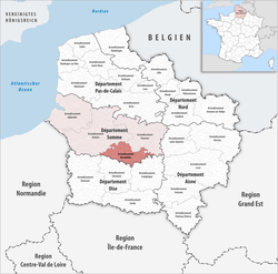 Location of the arrondissement in Hauts-de-France | |
| Country | France |
| Region | Hauts-de-France |
| Department | Somme |
| Communes | 111 |
| Subprefecture | Montdidier |
| Area¹ | |
| • Total | 781.9 km2 (301.9 sq mi) |
| Population (2013) | |
| • Total | 56,628 |
| • Density | 72/km2 (190/sq mi) |
| ¹ French Land Register data, which exclude lakes, ponds, and glaciers larger than 1 km² as well as the estuaries of rivers. | |
The arrondissement of Montdidier is an arrondissement of France in the Somme department in the Hauts-de-France region. Since the January 2017 reorganization of the arrondissements of Somme, it has 111 communes.[1]
Composition
Cantons
The cantons of the arrondissement of Montdidier are:
- Ailly-sur-Noye (partly)
- Moreuil (partly)
- Roye
Communes
The communes of the arrondissement of Montdidier, and their INSEE codes, are:
- Ailly-sur-Noye (80010)
- Andechy (80023)
- Armancourt (80027)
- Arvillers (80031)
- Assainvillers (80032)
- Aubercourt (80035)
- Aubvillers (80037)
- Ayencourt (80049)
- Balâtre (80053)
- Beaucourt-en-Santerre (80064)
- Becquigny (80074)
- Berteaucourt-lès-Thennes (80094)
- Beuvraignes (80101)
- Biarre (80103)
- Bouillancourt-la-Bataille (80121)
- Boussicourt (80125)
- Braches (80132)
- Bus-la-Mésière (80152)
- Cantigny (80170)
- Le Cardonnois (80174)
- Carrépuis (80176)
- Cayeux-en-Santerre (80181)
- Champien (80185)
- Chaussoy-Epagny (80188)
- Chirmont (80193)
- Contoire (80209)
- Cottenchy (80213)
- Coullemelle (80214)
- Courtemanche (80220)
- Crémery (80223)
- Cressy-Omencourt (80224)
- Damery (80232)
- Dancourt-Popincourt (80233)
- Davenescourt (80236)
- Démuin (80237)
- Domart-sur-la-Luce (80242)
- Dommartin (80246)
- L'Échelle-Saint-Aurin (80263)
- Erches (80278)
- Ercheu (80279)
- Esclainvillers (80283)
- Étalon (80292)
- Ételfay (80293)
- La Faloise (80299)
- Faverolles (80302)
- Fescamps (80306)
- Fignières (80311)
- Flers-sur-Noye (80315)
- Folleville (80321)
- Fonches-Fonchette (80322)
- Fontaine-sous-Montdidier (80326)
- Fouencamps (80337)
- Fransures (80349)
- Fresnoy-en-Chaussée (80358)
- Fresnoy-lès-Roye (80359)
- Goyencourt (80383)
- Gratibus (80386)
- Grivesnes (80390)
- Grivillers (80391)
- Gruny (80393)
- Guerbigny (80395)
- Guyencourt-sur-Noye (80403)
- Hailles (80405)
- Hallivillers (80407)
- Hangard (80414)
- Hangest-en-Santerre (80415)
- Hargicourt (80419)
- Hattencourt (80421)
- Herly (80433)
- Ignaucourt (80449)
- Jumel (80452)
- Laboissière-en-Santerre (80453)
- Laucourt (80467)
- Lawarde-Mauger-l'Hortoy (80469)
- Liancourt-Fosse (80473)
- Lignières (80478)
- Louvrechy (80494)
- Mailly-Raineval (80499)
- Malpart (80504)
- Marché-Allouarde (80508)
- Marestmontiers (80511)
- Marquivillers (80517)
- Mesnil-Saint-Georges (80541)
- Mézières-en-Santerre (80545)
- Montdidier (80561)
- Moreuil (80570)
- Morisel (80571)
- La Neuville-Sire-Bernard (80595)
- Piennes-Onvillers (80623)
- Pierrepont-sur-Avre (80625)
- Le Plessier-Rozainvillers (80628)
- Le Quesnel (80652)
- Quiry-le-Sec (80657)
- Remaugies (80667)
- Rogy (80675)
- Roiglise (80676)
- Rollot (80678)
- Rouvrel (80681)
- Roye (80685)
- Rubescourt (80687)
- Saint-Mard (80708)
- Sauvillers-Mongival (80729)
- Sourdon (80740)
- Thennes (80751)
- Thory (80758)
- Tilloloy (80759)
- Verpillières (80790)
- Villers-aux-Érables (80797)
- Villers-lès-Roye (80803)
- Villers-Tournelle (80805)
- Warsy (80822)
References
- ↑ "Arrêté préfectoral, 23 December 2016, p 3" (PDF). Retrieved 2017-08-04.
External links
This article is issued from
Wikipedia.
The text is licensed under Creative Commons - Attribution - Sharealike.
Additional terms may apply for the media files.