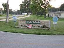
De Soto, Kansas
| De Soto, Kansas | ||
|---|---|---|
| City | ||
 Water tower (2017) | ||
| ||
 Location within Johnson County and Kansas | ||
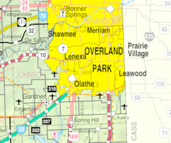 KDOT map of Johnson County (legend) | ||
| Coordinates: 38°58′45″N 94°58′7″W / 38.97917°N 94.96861°WCoordinates: 38°58′45″N 94°58′7″W / 38.97917°N 94.96861°W[1] | ||
| Country | United States | |
| State | Kansas | |
| Counties | Johnson, Leavenworth | |
| Townships | Lexington, Sherman | |
| Settled | 1828 | |
| Platted | 1857 | |
| Incorporated | 1897 | |
| Government | ||
| • Type | Mayor–Council | |
| • Mayor | Rick Walker | |
| • City Clerk | Lana McPherson | |
| Area[2] | ||
| • Total | 11.20 sq mi (29.00 km2) | |
| • Land | 11.07 sq mi (28.67 km2) | |
| • Water | 0.13 sq mi (0.33 km2) | |
| Elevation[1] | 860 ft (262 m) | |
| Population (2010)[3] | ||
| • Total | 5,720 | |
| • Estimate (2017)[4] | 6,107 | |
| • Density | 552/sq mi (213.0/km2) | |
| Time zone | UTC-6 (CST) | |
| • Summer (DST) | UTC-5 (CDT) | |
| ZIP codes | 66018, 66019 | |
| Area code | 913 | |
| FIPS code | 20-17850 [1][5] | |
| GNIS ID | 479178 [1][6] | |
| Website | desotoks.us | |
De Soto /dəˈsoʊtoʊ/ is a city in Johnson and Leavenworth counties in the U.S. state of Kansas,[1] and part of the Kansas City Metropolitan Area. The vast majority of the city, 11.13 square miles (28.8 km2), lies within Johnson County. As of the 2010 census, the city population was 5,720,[2] and in 2017 the estimated population was 6,107.[4] The area code is 913, and the two ZIP codes are 66018 and 66019.
History

De Soto was first settled in the spring of 1857, named for sixteenth-century Spanish explorer Hernando de Soto.[7] In 1858, John Possum, a Shawnee man, and Hattie Possum sold 80 acres (32 ha) to John F. Legate, S. Todd and Stratton and Williams for $1,200. The next sale was 80 acres to the De Soto Town Company in July 1861 for $1,176. Major James B. Abbot is remembered as one of the town's pioneer landowners and the builder of Abbot Hall. Today, Abbot Hall is one of two town museums.[8]
With the construction of the 9,080-acre (3,670 ha) Sunflower Army Ammunition Plant south of De Soto, the city's population boomed in the early 1940s during World War II. In May 1943, a Kansas City Star article reported "a town rapidly growing, with a population increase from 400 to 1,000 persons in under a year." This sudden overflow in population put a great strain on housing and other resources in the city; however, many original residents prospered during this time, buying property and starting new businesses. Production flowed steadily at the Sunflower Army Ammunition Plant until the plant went on standby in March 1948, with small-scale production following shortly after until its closure in 1993.[8]
1951 flood
In mid-July 1951, heavy rains led to a great rise of water in the Kansas River and other surrounding areas of the central United States, known as the Great Flood of 1951. De Soto, along the south side of the river, was severely damaged. The river crest at De Soto was recorded at 24.87 feet (7.58 m). Most of the downtown area was completely flooded, with over 2 feet (0.61 m) of standing water in some places.

Recent growth
Since the 2008 recession came to an end, growth in De Soto has steadily picked up, with new commercial development in the K-10 Business District, an expansion of major food production and medicine testing facilities, and two new 144-unit apartment complexes expected to be completed by 2018.
Lexington Lake Park opened just west of De Soto in 2017. It is currently the third-largest park operated by the Johnson County Parks and Recreation Department.
Arbor Ridge subdivision is a housing development which will enter phase 2 in 2017, allowing construction of 46, two-story, single family housing units.
Geography
De Soto is located in northwestern Johnson County at 38°58′45″N 94°58′7″W / 38.97917°N 94.96861°W (38.9791709, -94.9685783)[1] along the south side of the Kansas River, except for one small area north of the river in Leavenworth County.[9] According to the United States Census Bureau, the city has a total area of 11.20 square miles (29.00 km2), of which 11.07 square miles (28.67 km2) are land and 0.13 square miles (0.33 km2), or 1.15%, are water.[2]
Demographics
| Historical population | |||
|---|---|---|---|
| Census | Pop. | %± | |
| 1860 | 35 | — | |
| 1870 | 102 | 191.4% | |
| 1880 | 141 | 38.2% | |
| 1890 | 223 | 58.2% | |
| 1900 | 226 | 1.3% | |
| 1910 | 240 | 6.2% | |
| 1920 | 231 | −3.7% | |
| 1930 | 319 | 38.1% | |
| 1940 | 454 | 42.3% | |
| 1950 | 3,422 | 653.7% | |
| 1960 | 2,543 | −25.7% | |
| 1970 | 2,217 | −12.8% | |
| 1980 | 2,061 | −7.0% | |
| 1990 | 2,351 | 14.1% | |
| 2000 | 4,561 | 94.0% | |
| 2010 | 5,720 | 25.4% | |
| Est. 2017 | 6,107 | [4] | 6.8% |
| U.S. Decennial Census | |||
2010 census
As of the census[3] of 2010, there were 5,720 people, 2,007 households, and 1,523 families residing in the city. The population density was 516.7 inhabitants per square mile (199.5/km2). There were 2,204 housing units at an average density of 199.1 per square mile (76.9/km2). The racial makeup of the city was 89.7% White, 0.8% African American, 0.8% Native American, 0.4% Asian, 5.9% from other races, and 2.3% from two or more races. Hispanic or Latino of any race were 14.6% of the population.
There were 2,007 households of which 41.5% had children under the age of 18 living with them, 60.4% were married couples living together, 10.5% had a female householder with no husband present, 5.0% had a male householder with no wife present, and 24.1% were non-families. 19.0% of all households were made up of individuals and 6.3% had someone living alone who was 65 years of age or older. The average household size was 2.83 and the average family size was 3.25.
The median age in the city was 35.4 years. 28.6% of residents were under the age of 18; 8.8% were between the ages of 18 and 24; 26.5% were from 25 to 44; 26.3% were from 45 to 64; and 9.9% were 65 years of age or older. The gender makeup of the city was 50.2% male and 49.8% female.
2000 census
As of the census[5] of 2000, here were 4,561 people, 1,642 households, and 1,246 families residing in the city. The population density was 403.0/mi² (155.6/km²). There were 1,730 housing units at an average density of 152.9/mi² (59.0/km²). The racial makeup of the city was 94.80% White, 0.20% African American, 0.94% Native American, 0.37% Asian, 0.07% Pacific Islander, 1.69% from other races, and 1.93% from two or more races. Hispanic or Latino of any race were 6.86% of the population.
There were 1,642 households out of which 41.7% had children under the age of 18 living with them, 62.1% were married couples living together, 8.6% had a female householder with no husband present, and 24.1% were non-families. 21.3% of all households were made up of individuals and 7.4% had someone living alone who was 65 years of age or older. The average household size was 2.78 and the average family size was 3.23.
In the city, the population was spread out with 30.5% under the age of 18, 8.1% from 18 to 24, 32.5% from 25 to 44, 20.9% from 45 to 64, and 8.1% who were 65 years of age or older. The median age was 32 years. For every 100 females, there were 103.2 males. For every 100 females age 18 and over, there were 100.4 males.
The median income for a household in the city was $46,426, and the median income for a family was $52,219. Males had a median income of $36,203 versus $31,682 for females. The per capita income for the city was $23,141. About 3.2% of families and 5.2% of the population were below the poverty line, including 6.1% of those under age 18 and 13.1% of those age 65 or over.
Economy
Two local corporations, Great American Bank and Custom Foods, Inc., and one national corporation, Goodcents Deli Fresh Subs, are headquartered in De Soto. Huhtamaki Americas, Inc. and Engineered Air, two international enterprises, chose De Soto for their North American headquarters. In addition, Intervet, one of the world's leading manufacturers of animal health supplies, selected De Soto for one of its four U.S. manufacturing facilities.

Largest employers
as of January 2017, the largest employers in the city are:
| # | Employer | # of Employees |
|---|---|---|
| 1 | De Soto USD #232 | 1,655 |
| 2 | Huhtamaki | 640 |
| 3 | Engineered Air | 270 |
| 4 | Merck Animal Health | 180 |
| 5 | Rehrig Pacific | 110 |
| 6 | Custom Foods Inc | 108 |
| 7 | Goodcent's Deli Fresh Subs Headquarters | 95 |
| 8 | Hillside Village | 86 |
| 9 | Harps Food Stores | 31 |
Arts and culture
Between 1999 and 2000, a barn that had originally been built in the 1880s was moved piece by piece from a farmstead and placed on the Zimmerman farm at the northwest corner of the Kill Creek Road and K-10 interchange.[10] The barn was historically called the White-Waitmann barn but after its erection in 2000, by contractors and community volunteers, it also became known as the Zimmerman barn. The barn was not only a piece of American history, but it became well known throughout the community because the owner, Darrel Zimmerman, allows the public to pay a fee and use the barn for events such as weddings, graduations, and other meetings. However, a fierce storm demolished the barn in May 2010. The barn was rebuilt in 2013, after it was determined that Zimmerman could not locate another historic-looking barn to move on the location.[11]
The Day After was filmed from Edgerton Road to the main De Soto exit K-285(Lexington Ave) on ![]()

Regional attractions
Lexington Lake Park
Lexington Lake Park, named for Lexington Avenue in De Soto, opened in 2017. This park is maintained by the Johnson County Park and Recreation Department. The area surrounding Lexington Lake has undergone renovations to add a playground, walking, biking and horse-riding trails and lakefront benches. Plans to add an amphitheater, full sports center, and Recreational vehicle plaza are in the works.[12]
De Soto Days Festival
The city has been the host of the annual De Soto Days Festival. The fair begins on the Thursday before Labor Day and runs until the holiday itself, making it the third longest Labor Day festival in the County.[13] The fair has booths and three stages, entertaining 15,000 patrons annually on the 5 operating days.[14]
Winesong at Riverfest
Winesong at Riverfest is a major cultural attraction for the Kansas City area. The event, which began in 2012, is a wine festival hosted by the De Soto Rotary Club annually in early June. The event features wineries from the Midwest, and includes samples, appetizers, music and art competitions.[15] Annual attendance is 1,000.
Government
The De Soto government consists of a mayor and five council members, with a council appointed president.
Mayor
- Rick Walker (term expires 2022)
City Council President
- Lori Murdock (Presidential term expires 2019; council member term expires 2020)
City Council
- Lori Murdock (term expires 2020)
- Danny Lane (term expires 2020)
- Kevin Ritter (term expires 2021)
- Kevin Honomichl (term expires 2022)
- Rob Daniels (term expires 2022)
The council meets the first and third Thursday of each month at 7:00 p.m and the planning commission meets on the fourth Tuesday of the month. The De Soto City Council is an At-Large Representation, meaning the council serve the entire city, at-large, versus a single designated portion per member. City Hall is located at 32905 West 84th Street.
De Soto is a Kansas city of the second-class.
De Soto's ZIP codes are 66018 and 66019. 66019 was activated to serve the Sunflower Army Ammunition Plant in 1942, and has been kept in service since. De Soto is the least populous city in the state of Kansas to have more than one ZIP code.
2016 recall
An effort to recall Mayor Tim Maniez and City Councilmember Bill McDaniel from their positions was launched in February 2016, and garnered national attention.[16] Recall supporters submitted their petition applications against Maniez and McDaniel to the Johnson County Elections Board on February 18, 2016. Judy Macy and other De Soto residents filed petitions against Maniez and McDaniel due to concerns about meeting decorum. The petition against Maniez noted his lack of control over meetings, while the McDaniel's petition cited argumentative and negative behavior. Recall organizers also expressed frustration with the firing of city administrator Cynthia Wagner in February 2016. As of June 2017, the Johnson County Elections Board has not taken any action. The matter was considered abandoned on November 7, 2017 when both parties were voted against additional terms.[16]
Education
The city of De Soto is served by the De Soto school district.
Other local education institutions near De Soto include:
- University of Kansas
- Ottawa University adult campus
- University of Kansas-Edwards Campus
- Johnson County Community College
- Baker University Overland Park Campus
- Emporia State University - Overland Park Campus (Metro Learning Center)
Library
The Johnson County Library System maintains the De Soto Downtown Library.
In a 2006 downtown revitalization plan, the city states that it plans to open a municipal-maintained library.[17]
Media
Newspapers
The De Soto Explorer was started in 1998 and served as De Soto's main news source for 14 years, until the closure of the printing facility and website in 2012. In the fall of 2015, Discovering De Soto magazine released its first preview edition.[18] In 2017, the De Soto City Council motioned to fund issues of Discovering De Soto in order to distribute the magazine by mail and around local businesses. In 2018, the De Soto City Council once again motioned to fund upcoming issues of Discovering De Soto for the year.[19]
The Kansas City Star and the Lawrence Journal-World both cover and deliver to De Soto.
Television
All Kansas City stations broadcast in De Soto.
Radio
All Topeka and Kansas City stations broadcast in De Soto.
Transportation
Road
De Soto is served by several highways:

- Exit – Lexington Avenue, formerly

- Exit – Kill Creek Road
- Exit – Lexington Avenue, formerly

- Junction – 189th Street

- Junction – 158th Street

- Junction – 189th Street
- S. Wyandotte Road / 158th Street


- West 103rd Street / Lexington Avenue / West 83rd Street runs through De Soto. East on 83rd Street is Lenexa and Overland Park, west is Lawrence. West 103rd Street comes in from Lawrence, runs south of the city, turns into a four-lane road near Sunflower Nature Park and travels north into the city as Lexington Avenue until an intersection with West 83rd Street, and then turns east towards Lenexa.
Rail
De Soto was settled in 1828 as a city along the Kansas River. Several years later, in 1857, the Atchison, Topeka, Santa Fe Railway constructed track through northern portions of town, parallel to the river. De Soto's train depot was constructed along a siding around 1860.[20] In 1900, a railyard was constructed east of town to allow the switching of freight cars from Topeka to Kansas City. The yard consisted of seven rails along the main line and siding. Portions of the yard are still in use today to store unused freight cars.[21] However, only three lines remain, as the others were removed to save on maintenance.[22]
In 1942, during the construction of the Sunflower Army Ammunition Plant, the U.S. army constructed a spur through De Soto to connect the plant to a main rail line. To this day the spur is used for the industrial district shipments.[23]
Notable people
Notable individuals who were born in and/or have lived in De Soto include:
- Stanley Adams (1922-1999), U.S. Army Lieutenant Colonel, Medal of Honor Recipient[24]
- John Anderson, Jr. (1917-2014), 36th Governor of Kansas
- Howard Gloyd (1902-1978), herpetologist[25]
- Frank Lee (1873-1952), U.S. Representative from Missouri[26]
- John H. Outland (1871-1941), American Football Player and Coach
- Kenneth A. Spencer (1902-1960)
See also

References
- 1 2 3 4 5 6 Geographic Names Information System (GNIS) details for De Soto, Kansas; United States Geological Survey (USGS); October 13, 1978.
- 1 2 3 "Geographic Identifiers: 2010 Census Summary File 1 (G001): De Soto city, Kansas". American Factfinder. U.S. Census Bureau. Retrieved May 22, 2018.
- 1 2 "American FactFinder". United States Census Bureau. Retrieved 2012-07-06.
- 1 2 3 "Annual Estimates of the Resident Population: April 1, 2010 to July 1, 2017 (PEPANNRES): Incorporated Places: Kansas". American Factfinder. U.S. Census Bureau. Retrieved May 25, 2018.
- 1 2 "American FactFinder". United States Census Bureau. Archived from the original on 2013-09-11. Retrieved 2008-01-31.
- ↑ "US Board on Geographic Names". United States Geological Survey. 2007-10-25. Retrieved 2008-01-31.
- ↑ Blackmar, Frank Wilson (1912). Kansas: A Cyclopedia of State History, Embracing Events, Institutions, Industries, Counties, Cities, Towns, Prominent Persons, Etc. Standard Publishing Company. p. 516.
- 1 2 "About Us, Our History".
- ↑ "City of De Soto Official Zoning Map" (PDF). City of De Soto. May 30, 2013. Retrieved May 22, 2018.
- ↑ http://www.desotoks.org/KillCreekFarm.html
- ↑ http://www.kansascity.com/2010/05/13/1943534/storm-destroys-historic-zimmerman.html
- ↑ http://jcprd.com/pages/lexington_lake.cfm
- ↑ http://www.desotodays.com
- ↑ http://festivalnet.com/78501/De-Soto-Kansas/Festivals/De-Soto-Days-Festival
- ↑ http://www.winesongatriverfest.com
- 1 2 https://ballotpedia.org/Tim_Maniez_and_Bill_McDaniel_recall,_De_Soto,_Kansas_(2016)
- ↑ http://desotoks.org/useruploads/files/downtown_presentation_1106_2.pdf
- ↑ Discovering Desoto online magazine.
- ↑ https://drive.google.com/drive/folders/0B6Btc7LOS9CwcWhnaDB2c1RUUEE
- ↑ http://www.marc.org/Transportation/Plans-Studies/Transportation-Plans-and-Studies/Special-studies-and-projects/special-studies-pdfs/commuterrail_2002/Assessment5.aspx
- ↑ http://www.marc.org/Transportation/Plans-Studies/Transportation-Plans-and-Studies/Special-studies-and-projects/special-studies-pdfs/commuterrail_2002/Assessment5.aspx
- ↑ http://www.marc.org/Transportation/Plans-Studies/Transportation-Plans-and-Studies/Special-studies-and-projects/special-studies-pdfs/commuterrail_2002/Assessment5.aspx
- ↑ http://www.marc.org/Transportation/Plans-Studies/Transportation-Plans-and-Studies/Special-studies-and-projects/special-studies-pdfs/commuterrail_2002/Assessment5.aspx
- ↑ "Johnson County to remember a Kansas Congressional Medal of Honor recipient on Veterans Day". Johnson County, Kansas. Archived from the original on 2016-04-13. Retrieved 2016-04-01.
- ↑ "KHS Distinguished Life Members". Kansas Herpetological Society. Retrieved 2016-04-01.
- ↑ "Lee, Frank Hood (1873-1952)". Biographical Directory of the United States Congress. U.S. Congress. Retrieved 2016-04-01.
Further reading
County
- History of Leavenworth County Kansas; Jesse Hall and LeRoy Hand; Historical Publishing; 684 pages; 1921. (Download 27MB PDF eBook)
Kansas
- History of the State of Kansas; William G. Cutler; A.T. Andreas Publisher; 1883. (Online HTML eBook)
- Kansas : A Cyclopedia of State History, Embracing Events, Institutions, Industries, Counties, Cities, Towns, Prominent Persons, Etc; 3 Volumes; Frank W. Blackmar; Standard Publishing Co; 944 / 955 / 824 pages; 1912. (Volume1 - Download 54MB PDF eBook),(Volume2 - Download 53MB PDF eBook), (Volume3 - Download 33MB PDF eBook)
External links
| Wikimedia Commons has media related to De Soto, Kansas. |
- City of De Soto official website
- De Soto - Directory of Public Officials
- De Soto Chamber of Commerce
- De Soto City Map, KDOT
- De Soto, Kansas at Curlie (based on DMOZ)
- Grandpa's Old Ford Garage on YouTube, from Hatteberg's People on KAKE TV news
Municipalities and communities of Johnson County, Kansas, United States | ||
|---|---|---|
| Cities | 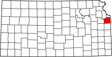 | |
| Unincorporated communities | ||
| Townships | ||
| Footnotes | ‡This populated place also has portions in an adjacent county or counties | |
Municipalities and communities of Leavenworth County, Kansas, United States | ||
|---|---|---|
| Cities |  | |
| CDPs | ||
| Unincorporated communities | ||
| Townships | ||
| Ghost town | ||
| Footnotes | ‡This populated place also has portions in an adjacent county or counties | |
Kansas City metropolitan area's cities and counties | ||
|---|---|---|
| Central city |  | |
| Largest cities (over 100,000 in 2000) | ||
| Medium-sized cities (10,000 to 100,000 in 2000) | ||
| Smaller Cities (between 5,000 and 9,900 in 2010) | ||
| Counties | ||