Illinois Route 351
| ||||
|---|---|---|---|---|
 | ||||
| Route information | ||||
| Maintained by IDOT | ||||
| Length | 8.55 mi[1] (13.76 km) | |||
| Existed | 1966[2] – present | |||
| Major junctions | ||||
| South end |
| |||
|
| ||||
| North end |
| |||
| Location | ||||
| Counties | LaSalle | |||
| Highway system | ||||
| ||||

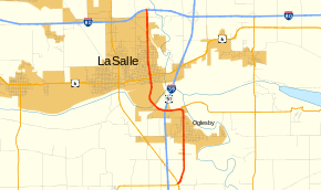
Illinois Route 351 is a north–south state route that leads from Illinois Route 71 and Illinois Route 251 by Oglesby through downtown LaSalle to Interstate 80. It is 8.55 miles (13.76 km) long.[1]
Route description
Illinois 351 is the former Business U.S. Route 51 through La Salle. It crosses over the Illinois River on the Shippingsport Bridge south of La Salle and passes underneath the Abraham Lincoln Memorial Bridge as it climbs out of the Illinois River Valley. Like Illinois Route 251, Illinois 351 can be considered a spur off its parent, U.S. Route 51.
History
Prior to 1963, US 51 traveled along IL 351's path. From 1963 to 1966, it became US 51 Business (US 51 Bus.) as US 51 was rerouted west of LaSalle in 1966. It then was changed to IL 351 as US 51 was rerouted onto a new freeway (I-39) to the east of LaSalle in 1992.
Major intersections
The entire route is in La Salle County.
| Location | mi[1] | km | Destinations | Notes | |
|---|---|---|---|---|---|
| | 0.00 | 0.00 | Southern end of IL 71 overlap | ||
| Oglesby | 3.31 | 5.33 | Northern end of IL 71 overlap | ||
| LaSalle | 5.62 | 9.04 | Southern end of US 6 overlap | ||
| 5.78 | 9.30 | Northern end of US 6 overlap | |||
| 8.55 | 13.76 | ||||
1.000 mi = 1.609 km; 1.000 km = 0.621 mi
| |||||
References
- 1 2 3 "T2 GIS Data". Illinois Department of Transportation. 2013. Retrieved August 9, 2014.
- ↑ Carlson, Rick. Illinois Highways Page: Routes 203 thru end. Last updated March 15, 2006. Retrieved March 27, 2006.
External links
Route map: