Équancourt
| Équancourt | |
|---|---|
| Commune | |
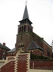 St. Martin's Church | |
 Équancourt Location within Hauts-de-France region  Équancourt | |
| Coordinates: 50°02′12″N 3°01′10″E / 50.0367°N 3.0194°ECoordinates: 50°02′12″N 3°01′10″E / 50.0367°N 3.0194°E | |
| Country | France |
| Region | Hauts-de-France |
| Department | Somme |
| Arrondissement | Péronne |
| Canton | Péronne |
| Intercommunality | Haute Somme |
| Government | |
| • Mayor (2001–2008) | Gérard Bouteille |
| Area1 | 7.79 km2 (3.01 sq mi) |
| Population (2006)2 | 316 |
| • Density | 41/km2 (110/sq mi) |
| Time zone | UTC+1 (CET) |
| • Summer (DST) | UTC+2 (CEST) |
| INSEE/Postal code | 80275 /80360 |
| Elevation |
88–147 m (289–482 ft) (avg. 96 m or 315 ft) |
|
1 French Land Register data, which excludes lakes, ponds, glaciers > 1 km2 (0.386 sq mi or 247 acres) and river estuaries. 2 Population without double counting: residents of multiple communes (e.g., students and military personnel) only counted once. | |
Équancourt is a commune in the Somme department in Hauts-de-France in northern France.
Geography
Équancourt is situated on the D58 road, some 32 km (20 mi) northwest of Saint Quentin.
Population
| Year | 1962 | 1968 | 1975 | 1982 | 1990 | 1999 | 2006 |
|---|---|---|---|---|---|---|---|
| Population | 390 | 417 | 326 | 320 | 293 | 280 | 316 |
| From the year 1962 on: No double counting—residents of multiple communes (e.g. students and military personnel) are counted only once. | |||||||
See also
References
External links
| Wikimedia Commons has media related to Équancourt. |
- on the Quid website (in French)
This article is issued from
Wikipedia.
The text is licensed under Creative Commons - Attribution - Sharealike.
Additional terms may apply for the media files.