Mankato, Kansas
| Mankato, Kansas | |
|---|---|
| City and County seat | |
 Location within Jewell County and Kansas | |
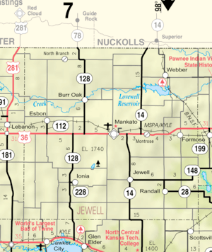 KDOT map of Jewell County (legend) | |
| Coordinates: 39°47′14″N 98°12′33″W / 39.78722°N 98.20917°WCoordinates: 39°47′14″N 98°12′33″W / 39.78722°N 98.20917°W | |
| Country | United States |
| State | Kansas |
| County | Jewell |
| Area[1] | |
| • Total | 1.01 sq mi (2.62 km2) |
| • Land | 1.01 sq mi (2.62 km2) |
| • Water | 0 sq mi (0 km2) |
| Elevation | 1,775 ft (541 m) |
| Population (2010)[2] | |
| • Total | 869 |
| • Estimate (2016)[3] | 821 |
| • Density | 860/sq mi (330/km2) |
| Time zone | UTC-6 (CST) |
| • Summer (DST) | UTC-5 (CDT) |
| ZIP code | 66956 |
| Area code | 785 |
| FIPS code | 20-44300 [4] |
| GNIS ID | 0471996 [5] |
| Website | mankatoks.com |
Mankato is a city in and the county seat of Jewell County, Kansas, United States.[6] As of the 2010 census, the city population was 869.[7]
History
Mankato was originally called Jewell Center, and under the latter name laid out in 1872.[8] It was renamed Mankato in 1880 after Mankato, Minnesota.[9] Mankato was incorporated as a city in 1880.[8]
The first post office in the town was established as Jewell Center in August 1872. The post office was renamed Mankato in April 1880.[10]
Geography
Mankato is located at 39°47′14″N 98°12′33″W / 39.78722°N 98.20917°W (39.787220, -98.209274).[11] According to the United States Census Bureau, the city has a total area of 1.01 square miles (2.62 km2), all land.[1]
Demographics
| Historical population | |||
|---|---|---|---|
| Census | Pop. | %± | |
| 1880 | 506 | — | |
| 1890 | 800 | 58.1% | |
| 1900 | 890 | 11.3% | |
| 1910 | 1,155 | 29.8% | |
| 1920 | 1,326 | 14.8% | |
| 1930 | 1,404 | 5.9% | |
| 1940 | 1,426 | 1.6% | |
| 1950 | 1,462 | 2.5% | |
| 1960 | 1,231 | −15.8% | |
| 1970 | 1,287 | 4.5% | |
| 1980 | 1,205 | −6.4% | |
| 1990 | 1,037 | −13.9% | |
| 2000 | 976 | −5.9% | |
| 2010 | 869 | −11.0% | |
| Est. 2016 | 821 | [3] | −5.5% |
| U.S. Decennial Census[12] | |||
2010 census
As of the census[2] of 2010, there were 869 people, 405 households, and 242 families residing in the city. The population density was 860.4 inhabitants per square mile (332.2/km2). There were 486 housing units at an average density of 481.2 per square mile (185.8/km2). The racial makeup of the city was 97.0% White, 0.3% African American, 0.3% Native American, 0.5% Asian, 0.5% from other races, and 1.4% from two or more races. Hispanic or Latino of any race were 1.0% of the population.
There were 405 households of which 22.0% had children under the age of 18 living with them, 50.9% were married couples living together, 6.4% had a female householder with no husband present, 2.5% had a male householder with no wife present, and 40.2% were non-families. 37.5% of all households were made up of individuals and 18.8% had someone living alone who was 65 years of age or older. The average household size was 2.08 and the average family size was 2.71.
The median age in the city was 51.5 years. 19.2% of residents were under the age of 18; 5% were between the ages of 18 and 24; 17.1% were from 25 to 44; 30.4% were from 45 to 64; and 28.3% were 65 years of age or older. The gender makeup of the city was 48.2% male and 51.8% female.
2000 census
As of the census[4] of 2000, there were 976 people, 436 households, and 256 families residing in the city. The population density was 964.0 people per square mile (373.1/km²). There were 509 housing units at an average density of 502.7 per square mile (194.6/km²). The racial makeup of the city was 98.67% White, 0.10% Asian, 0.20% from other races, and 1.02% from two or more races. Hispanic or Latino of any race were 0.92% of the population.
There were 436 households out of which 24.1% had children under the age of 18 living with them, 52.5% were married couples living together, 5.3% had a female householder with no husband present, and 41.1% were non-families. 39.0% of all households were made up of individuals and 21.3% had someone living alone who was 65 years of age or older. The average household size was 2.14 and the average family size was 2.86.
In the city, the population was spread out with 21.8% under the age of 18, 4.5% from 18 to 24, 21.1% from 25 to 44, 23.0% from 45 to 64, and 29.6% who were 65 years of age or older. The median age was 46 years. For every 100 females, there were 95.2 males. For every 100 females age 18 and over, there were 87.5 males.
The median income for a household in the city was $29,286, and the median income for a family was $41,429. Males had a median income of $30,000 versus $17,813 for females. The per capita income for the city was $17,457. About 4.9% of families and 9.2% of the population were below the poverty line, including 9.0% of those under age 18 and 10.5% of those age 65 or over.
Education
Mankato is home to USD 107 Rock Hills. The Rock Hills High School mascot is Grizzlies.[13]
Prior to school unification, Mankato was home to Mankato High School with the mascot Cougars. The Mankato Cougars[14] won the Kansas State High School boys class B basketball championship in 1943.[15]
Notable people
- Wint Smith (1892–1976) Congressman, represented Kansas from 1947-1961.[16]
- Ernest Tippin (1890-1958) Olympic sharpshooter.[17]
References
- 1 2 "US Gazetteer files 2010". United States Census Bureau. Archived from the original on 2012-01-24. Retrieved 2012-07-06.
- 1 2 "American FactFinder". United States Census Bureau. Retrieved 2012-07-06.
- 1 2 "Population and Housing Unit Estimates". Retrieved June 9, 2017.
- 1 2 "American FactFinder". United States Census Bureau. Retrieved 2008-01-31.
- ↑ "US Board on Geographic Names". United States Geological Survey. 2007-10-25. Retrieved 2008-01-31.
- ↑ "Find a County". National Association of Counties. Retrieved 2011-06-07.
- ↑ "2010 City Population and Housing Occupancy Status". U.S. Census Bureau. Archived from the original on July 21, 2011. Retrieved March 6, 2011.
- 1 2 Blackmar, Frank Wilson (1912). Kansas: A Cyclopedia of State History, Volume 2. Standard Publishing Company. p. 214.
- ↑ Kansas State Historical Society (1916). Biennial Report of the Board of Directors of the Kansas State Historical Society. Kansas State Printing Plant. p. 211.
- ↑ "Kansas Post Offices, 1828-1961". Kansas Historical Society. Retrieved 11 June 2014.
- ↑ "US Gazetteer files: 2010, 2000, and 1990". United States Census Bureau. 2011-02-12. Retrieved 2011-04-23.
- ↑ United States Census Bureau. "Census of Population and Housing". Retrieved January 13, 2015.
- ↑ "Rock Hills". USD 107. Retrieved 1 January 2017.
- ↑ "Mankato Downs White Rock 46-26", The Belleville Telescope, 26 September 1985, p.10.
- ↑ "Basketball". KSHSAA. Retrieved 3 January 2017.
- ↑ "Smith, Wint". Biographical Directory of the United States Congress. Retrieved 2011-08-04.
- ↑ "Ernest Tippin". Retrieved 5 January 2015.
Further reading
- History of the State of Kansas; William G. Cutler; A.T. Andreas Publisher; 1883. (Online HTML eBook)
- Kansas : A Cyclopedia of State History, Embracing Events, Institutions, Industries, Counties, Cities, Towns, Prominent Persons, Etc; 3 Volumes; Frank W. Blackmar; Standard Publishing Co; 944 / 955 / 824 pages; 1912. (Volume1 - Download 54MB PDF eBook),(Volume2 - Download 53MB PDF eBook), (Volume3 - Download 33MB PDF eBook)
External links
| Wikimedia Commons has media related to Mankato, Kansas. |
- City
- Schools
- USD 107, local school district
- Maps
- Mankato City Map, KDOT
Municipalities and communities of Jewell County, Kansas, United States | ||
|---|---|---|
| Cities | 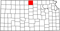 | |
| Unincorporated communities | ||
| Townships | ||