Westmoreland, Kansas
| Westmoreland, Kansas | |
|---|---|
| City and County seat | |
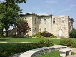 Pottawatomie County Court House (2009) | |
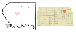 Location within Pottawatomie County and Kansas | |
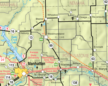 KDOT map of Pottawatomie County (legend) | |
| Coordinates: 39°23′41″N 96°24′51″W / 39.39472°N 96.41417°WCoordinates: 39°23′41″N 96°24′51″W / 39.39472°N 96.41417°W | |
| Country | United States |
| State | Kansas |
| County | Pottawatomie |
| Area[1] | |
| • Total | 0.52 sq mi (1.35 km2) |
| • Land | 0.52 sq mi (1.35 km2) |
| • Water | 0 sq mi (0 km2) |
| Elevation | 1,201 ft (366 m) |
| Population (2010)[2] | |
| • Total | 778 |
| • Estimate (2016)[3] | 769 |
| • Density | 1,500/sq mi (580/km2) |
| Time zone | UTC-6 (CST) |
| • Summer (DST) | UTC-5 (CDT) |
| ZIP codes | 66426, 66549 |
| Area code | 785 |
| FIPS code | 20-77200 [4] |
| GNIS ID | 0476096 [5] |
| Website | City Website |
Westmoreland is a city in and the county seat of Pottawatomie County, Kansas, United States.[6] As of the 2010 census, the city population was 778.[7]
History
Westmoreland was platted in 1871.[8] It was named after Westmoreland County, Pennsylvania.[9]
Geography
Westmoreland is located at 39°23′41″N 96°24′51″W / 39.39472°N 96.41417°W (39.394770, -96.414154).[10] According to the United States Census Bureau, the city has a total area of 0.52 square miles (1.35 km2), all of it land.[1]
Demographics
| Historical population | |||
|---|---|---|---|
| Census | Pop. | %± | |
| 1890 | 478 | — | |
| 1900 | 620 | 29.7% | |
| 1910 | 484 | −21.9% | |
| 1920 | 386 | −20.2% | |
| 1930 | 501 | 29.8% | |
| 1940 | 532 | 6.2% | |
| 1950 | 416 | −21.8% | |
| 1960 | 460 | 10.6% | |
| 1970 | 485 | 5.4% | |
| 1980 | 598 | 23.3% | |
| 1990 | 541 | −9.5% | |
| 2000 | 631 | 16.6% | |
| 2010 | 778 | 23.3% | |
| Est. 2016 | 769 | [3] | −1.2% |
| U.S. Decennial Census | |||
Westmoreland is part of the Manhattan, Kansas Metropolitan Statistical Area.
2010 census
As of the census[2] of 2010, there were 778 people, 301 households, and 192 families residing in the city. The population density was 1,496.2 inhabitants per square mile (577.7/km2). There were 337 housing units at an average density of 648.1 per square mile (250.2/km2). The racial makeup of the city was 96.5% White, 0.4% African American, 0.9% Native American, 0.1% Asian, 0.3% Pacific Islander, 0.9% from other races, and 0.9% from two or more races. Hispanic or Latino of any race were 2.4% of the population.
There were 301 households of which 33.9% had children under the age of 18 living with them, 48.5% were married couples living together, 9.3% had a female householder with no husband present, 6.0% had a male householder with no wife present, and 36.2% were non-families. 32.6% of all households were made up of individuals and 17.3% had someone living alone who was 65 years of age or older. The average household size was 2.36 and the average family size was 2.97.
The median age in the city was 41.5 years. 24.9% of residents were under the age of 18; 5.6% were between the ages of 18 and 24; 22.4% were from 25 to 44; 25.8% were from 45 to 64; and 21.5% were 65 years of age or older. The gender makeup of the city was 47.7% male and 52.3% female.
2000 census
As of the census[4] of 2000, there were 631 people, 262 households, and 171 families residing in the city. The population density was 1,200.8 people per square mile (459.7/km²). There were 293 housing units at an average density of 557.6 per square mile (213.4/km²). The racial makeup of the city was 98.42% White, 0.32% Native American, 0.48% from other races, and 0.79% from two or more races. Hispanic or Latino of any race were 1.58% of the population.
There were 262 households out of which 27.9% had children under the age of 18 living with them, 55.3% were married couples living together, 7.3% had a female householder with no husband present, and 34.4% were non-families. 30.9% of all households were made up of individuals and 18.3% had someone living alone who was 65 years of age or older. The average household size was 2.26 and the average family size was 2.85.
In the city, the population was spread out with 22.8% under the age of 18, 5.5% from 18 to 24, 25.2% from 25 to 44, 21.1% from 45 to 64, and 25.4% who were 65 years of age or older. The median age was 43 years. For every 100 females, there were 83.4 males. For every 100 females age 18 and over, there were 81.7 males.
The median income for a household in the city was $31,583, and the median income for a family was $40,833. Males had a median income of $26,071 versus $19,844 for females. The per capita income for the city was $17,290. About 5.2% of families and 11.5% of the population were below the poverty line, including 13.4% of those under age 18 and 16.0% of those age 65 or over.
Education
School unification consolidated St. George and Westmoreland schools forming USD 323 Rock Creek. Rock Creek High School is located approximately halfway between the towns. The Rock Creek High School mascot is Rock Creek Mustangs. Westmoreland Elementary School is located in Westmoreland.[11]
Westmoreland High School was closed through school unification in 1991. The Westmoreland High School mascot was Westmoreland Wildcats.[12]
Notable people
- Benjamin Butler, painter
- Billie Moore, basketball coach, member of the Basketball Hall of Fame
- Frank Wiziarde, better known as "Whizzo the Clown"
References
- 1 2 "US Gazetteer files 2010". United States Census Bureau. Archived from the original on 2012-07-14. Retrieved 2012-07-06.
- 1 2 "American FactFinder". United States Census Bureau. Retrieved 2012-07-06.
- 1 2 "Population and Housing Unit Estimates". Retrieved June 9, 2017.
- 1 2 "American FactFinder". United States Census Bureau. Retrieved 2008-01-31.
- ↑ "US Board on Geographic Names". United States Geological Survey. 2007-10-25. Retrieved 2008-01-31.
- ↑ "Find a County". National Association of Counties. Retrieved 2011-06-07.
- ↑ "2010 City Population and Housing Occupancy Status". U.S. Census Bureau. Retrieved March 27, 2011.
- ↑ Blackmar, Frank Wilson (1912). Kansas: A Cyclopedia of State History, Volume 2. Standard Publishing Company. p. 902.
- ↑ Kansas State Historical Society (1916). Biennial Report of the Board of Directors of the Kansas State Historical Society. Kansas State Printing Plant. p. 262.
- ↑ "US Gazetteer files: 2010, 2000, and 1990". United States Census Bureau. 2011-02-12. Retrieved 2011-04-23.
- ↑ "Rock Creek USD 323". USD 323. Retrieved 4 January 2017.
- ↑ "Fired-Up Westmoreland Spoilers", The Manhattan Mercury, 28 February 1971, p.12.
Further reading
- History of the State of Kansas; William G. Cutler; A.T. Andreas Publisher; 1883. (Online HTML eBook)
- Kansas : A Cyclopedia of State History, Embracing Events, Institutions, Industries, Counties, Cities, Towns, Prominent Persons, Etc; 3 Volumes; Frank W. Blackmar; Standard Publishing Co; 944 / 955 / 824 pages; 1912. (Volume1 - Download 54MB PDF eBook),(Volume2 - Download 53MB PDF eBook), (Volume3 - Download 33MB PDF eBook)
External links
| Wikimedia Commons has media related to Westmoreland, Kansas. |
- City
- Schools
- USD 323, local school district
- Westmoreland Elementary School
- Maps
- Westmoreland City Map, KDOT
Municipalities and communities of Pottawatomie County, Kansas, United States | ||
|---|---|---|
| Cities |  | |
| Unincorporated communities | ||
| Footnotes | ‡This populated place also has portions in an adjacent county or counties | |