Nemaha River basin
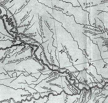
This excerpt from the Lewis and Clark map of 1814 shows the rivers of southwest Iowa, southeast Nebraska, and northwest Missouri. The "Little" and "Great" "Ne-ma-haw" Rivers are seen at the west-central edge of the map.
The Nemaha River basin includes the areas of the U.S. state of Nebraska below the Platte River basin that drain directly into the Missouri River. The major streams of the drainage include Weeping Water Creek, Muddy Creek, Little Nemaha River, and Big Nemaha River. The basin has a total area of approximately 2,800 square miles (7,300 km2), and includes much of southeastern Nebraska.
The name 'Nemaha' originates in the Ioway-Otoe-Missouria phrase ñí-máha, which means 'water-soil' and refers to the muddy water at corn-planting time.
External links
Coordinates: 40°07′N 95°39′W / 40.117°N 95.650°W
This article is issued from
Wikipedia.
The text is licensed under Creative Commons - Attribution - Sharealike.
Additional terms may apply for the media files.