Kaushambi district
| Kaushambi district | |
|---|---|
| District of Uttar Pradesh | |
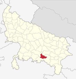 Location of Kaushambi district in Uttar Pradesh | |
| Country | India |
| State | Uttar Pradesh |
| Administrative division | Allahabad |
| Headquarters | Manjhanpur |
| Tehsils | 3 |
| Area | |
| • Total | 1,903.17 km2 (734.82 sq mi) |
| Population (2011) | |
| • Total | 1,596,909 |
| • Density | 840/km2 (2,200/sq mi) |
| Demographics | |
| • Literacy | 63.69 per cent |
| Website | Official website |
Kaushambi district is one of the districts of Uttar Pradesh state of India, and Manjhanpur town is the district headquarters. The present Kaushambi district was carved out of Allahabad district on 4th April 1997. The District Headquarter, Manjhanpur is situated in the south-west of the Allahabad on the north bank of the Yamuna river,about 55 km away from Allahabad. It is surrounded by the districts Chitrakoot in the south, Pratapgarh in the north, Allahabad in the east & Fatehpur in the west. . Kaushambi is suburb part of Allahabad Division.
History
In ancient India it was the capital of the Vatsa Mahajanapada,[1][2][3] one of 16 such regions. The Puranas state that Vatsa was named after a Kaśī king.[4] The Ramayana and the Mahabharata attribute the credit of founding its capital Kauśāmbī to a Chedi prince Kuśa or Kuśāmba. The Puranas state that after the washing away of Hastinapura by the Ganges, the Bhāratas king Nicakṣu, great-great grandson of Janamejaya, abandoned the city and settled in Kauśāmbī. This is supported by the Svapnavāsavadattā and the Pratijñā-Yaugandharāyaṇa attributed to Bhāsa. Both of them have described the king Udayana as a scion of the Bhāratas family (Bhārata-kula). The Puranas provide a list of Nicakṣu’s successors which ends with king Kṣemaka.[5]Gautama Buddha visited Kaushambi several times during the reign of Udayana on his effort to spread the dharma, the Noble Eightfold Path and the Four Noble Truths. Udayana was a Buddhist upāsaka. The Chinese translation of the Buddhist canonical text Ekottara Āgama states that the first image of Buddha, carved out of sandalwood was made under the instruction of Udayana.According to the Puranas, the 4 successors of Udayana were Vahināra, DanḍapāṇI, Niramitra and Kṣemaka. Later, Vatsa was annexed by Avanti. Maniprabha, the great-grandson of Pradyota, ruled at Kauśāmbī as a prince of Avanti.[8]Ashoka gave importance to Kaushambi and placed a pillar of Ashoka in Kaushambi, which has inscriptions there in Pali. A Jaina derasar was also constructed in Kaushambi. Both the pillar and the temple still exist there and the ruins of Vatsa and its university are still being excavated by archaeologists.Kaushambi is also the birthplace of sixth Jain Tirthankar Padam Prabhu Ji.
The present Kaushambi district was carved out of Allahabad district on 4 April 1997.
In 2006 the Ministry of Panchayati Raj named Kaushambi one of the country's 250 most backward districts (out of a total of 640).[6] It is one of the 34 districts in Uttar Pradesh currently receiving funds from the Backward Regions Grant Fund Programme (BRGF).[6]
Demographics
According to the 2011 census Kaushambi district has a population of 1,596,909,[7] roughly equal to the nation of Guinea-Bissau[8] or the US state of Idaho.[9] This gives it a ranking of 313th in India (out of a total of 640).[7] The district has a population density of 897 inhabitants per square kilometre (2,320/sq mi) .[7] Its population growth rate over the decade 2001-2011 was 23.49%.[7] Kaushambi has a sex ratio of 905 females for every 1000 males,[7] and a literacy rate of 63.69%.[7]
Facts
Kaushambi is a newly created district out of Allahabad. It consists of major towns such as Sarai akil, Chail, Manjhanpur, Bharwari, Daranagar, Kashiya Muratganj, Sirathu, Karari and Kara.It is very easy to reach Kaushambi by road; it is approximately 45 km from Allahabad. This site is good for history lovers who have interest in ancient history.Many Kaushambi artifacts are in Allahabad Museum. It has a few excavated sites, including a Pillar of Ashoka with inscriptions in Pali; surrounding the pillar is a historic site of ruins of the Vatsa Mahajanapada and its university.There is a Jain derasar 14 km from Sarai Akil. The soil is very fertile and it is world-famous for the Surkha Guava. The Surkha region lies mainly in Allahabad.
Sports
Boxing - Late Honorary Captain Mohammad Aslam Siddiqui 'VSM' was a heavyweight boxer from Bharwari, Kaushambi-Uttar Pradesh. He dominated the Asian and Indian amateur boxing territory for almost 5 consecutive years. He was the winner of the Silver medal in the 1973 and 1975 Asian Amateur Boxing Championship held in Thailand and Yokohama respectively. He has won the National Championship in the heavyweight category an astounding 5 consecutive years (1973-78). Hon'ble Gyani Zail Singh, 7th President of India awarded the VISHISHT SEWA MEDAL (VSM) on 21st May 1986 for his excellent achievement in International Boxing and Hon'ble Shankar Dayal Sharma, 9th president of India awarded the Honorary Captain Rank for his excellent contribution in the Indian Army on 26th January 1993. Apart from International Boxing medals and honored, he got lots of medals for fighting in several Indian Army Operations and War against Pakistan. He ended on a very good note in Mecca (Saudi Arabia) during the Hajj in Dec 2007.
http://amateur-boxing.strefa.pl/Championships/AsianChampionships1973.html http://amateur-boxing.strefa.pl/Championships/AsianChampionships1975.html
References
- ↑ Geographical Review of India. Original from the University of Michigan: Geographical Society of India. 1951. p. 27.
- ↑ Hermann Kulke, Dietmar Rothermund (2004). A History of India. Routledge. p. 52. ISBN 0-415-32920-5.
- ↑ Dr.K.K.Sharma (2009-01-01). Civil Services Pre.Exam.Indian History ( From Earliest Times To 1964 A.D.). Upkar Prakashan. ISBN 9788174828880.
- ↑ Pargiter, F.E. (1972) Ancient Indian Historical Tradition, Motilal Banarasidass, Delhi, pp.269-70
- ↑ Raychaudhuri, Hemchandra (1972) Political History of Ancient India, University of Calcutta, Calcutta, p.117-8
- 1 2 Ministry of Panchayati Raj (8 September 2009). "A Note on the Backward Regions Grant Fund Programme" (PDF). National Institute of Rural Development. Archived from the original (PDF) on 5 April 2012. Retrieved 27 September 2011.
- 1 2 3 4 5 6 "Kaushambi District Population Census 2011, Uttar Pradesh literacy sex ratio and density". Census Organization of India. 2012. Archived from the original on 3 January 2013.
- ↑ US Directorate of Intelligence. "Country Comparison:Population". Retrieved 2011-10-01.
Guinea-Bissau 1,596,677 July 2011 est.
- ↑ "2010 Resident Population Data". U. S. Census Bureau. Archived from the original on 1 January 2011. Retrieved 2011-09-30.
Idaho 1,567,582
External links
Places adjacent to Kaushambi district | ||||||||||
|---|---|---|---|---|---|---|---|---|---|---|
| ||||||||||
Coordinates: 25°31′51″N 81°22′38″E / 25.530744°N 81.377292°E