Kangra district
| Kangra Nagarkot , Trigart | |
|---|---|
| District | |
 | |
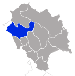 Location in Himachal Pradesh, India | |
 Kangra Location of the district headquarters in India | |
| Coordinates: 32°13′0″N 76°19′0″E / 32.21667°N 76.31667°ECoordinates: 32°13′0″N 76°19′0″E / 32.21667°N 76.31667°E | |
| Country | India |
| State | Himachal Pradesh |
| Tehsils | |
| Headquarters | Dharamshala |
| Government | |
| • Divisional Commissioner | RAJIV SHANKAR, IAS |
| • Superintendent of Police | SANTOSH PATIAL, IPS |
| Area | |
| • Total | 5,739 km2 (2,216 sq mi) |
| Population (2011) | |
| • Total | 1,510,075 |
| • Density | 263/km2 (680/sq mi) |
| Languages | |
| • Official | Hindi |
| Time zone | UTC+5:30 (IST) |
| PIN | 1761xx |
| Telephone | 91 1894 xxxxxx |
| Largest city | Dharamsala & Kangra |
| Gender ratio | 1013 females/1000 males |
| Literacy rate | 86.49% |
| Lok Sabha Constituency | Kangra |
| Vidhan Sabha Constituencies |
|
| Climate | ETh (Köppen) |
| Avg. summer temperature | 32 °C (90 °F) |
| Avg. winter temperature | 20 °C (68 °F) |
| Website |
hpkangra |
Kangra is the most populous[1] district of the Indian state of Himachal Pradesh, India. Dharamshala is the administrative headquarters of the district. It is the home of the Masrur Temples, also known as the Himalayan Pyramids.
History
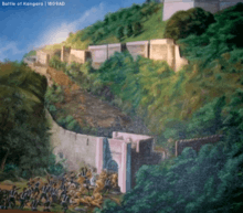
Kangra is known for having the oldest serving Royal Dynasty in the world, the Katoch. In 1758, Raja Ghamand Chand was appointed nazim or governor of Jullundur Doab under the Afghans. Ghamand Chand was a brave and strong ruler who restored the prestige of Kangra. As he was unable to capture Kangra fort, he built another fort at Tira Sujanpur on the left bank of the Beas, almost opposite to Alampur on a hill overlooking the town. He died in 1774 and was succeeded by his son, Tegh Chand, who died too soon in 1775.[2] Kangra became a district of British India in 1846, when it was ceded to British India at the conclusion of the First Anglo-Sikh War. The British district included the present-day districts of Kangra, Hamirpur, Kullu, and Lahul and Spiti. Kangra District was part of the British province of Punjab. The administrative headquarters of the district were initially at Kangra, but were moved to Dharamshala in 1855.[3][4]
Demographics
According to the 2011 census Kangra district has a population of 1,507,223,[1] roughly equal to the nation of Gabon[5] or the US state of Hawaii.[6] This gives it a ranking of 331st in India (out of a total of 640).[1] The district has a population density of 263 inhabitants per square kilometre (680/sq mi) .[1] Its population growth rate over the decade 2001–2011 was 12.56%.[1] Kangra has a sex ratio of 1013 females for every 1000 males,[1] and a literacy rate of 86.49%.[1]
District Highlights of 2011 Census[7]
- Kangra district has the highest number of 3,869 villages among the 12 district of the state.
- Kangra district occupies the 1st rank among the districts in terms of population.
- Kangra district occupies the 2nd position in terms of sex ratio among the districts of the state with 1,012 females per 1,000 males as compared to 972 females per 1,000 males of state average.
- Kangra district stands 1st position in terms of its working force having total workers of 675,170 persons against 3,559,422 working persons of the state.
- Kangra district stands at 5th positions in terms of decadal population growth (2001-2011) of 12.8 per cent persons in comparison to state decadal population growth of 12.9 per cent persons.
- In terms of density of population per sq.km., Kangra district with 263 persons per sq.km. stands at 5th rank in the state.
- Kangra district occupies 1st rank among the districts of the state in terms of literate population. It has a literate population of 1,152,640 persons.
- Kangra district holds the 2nd rank in terms of scheduled tribe population in the state. It has reported 84,564 persons as scheduled tribe.
- The economy of Kangra district is mainly depends on agriculture. It has returned 303,007 persons as cultivators and holds the 2nd position among the districts of the state
- All the inhabited villages of the district enjoy the facility of electricity and potable drinking water.
- Kangra district is also known for its attractive tourist destinations. Dharamsala, Kangra, Palampur, Baijnath, Jawalamukhi and Masroor are the famous places of tourist interest in the district. McLeodganj in Dharamsala is a seat of the Dalai Lama has become a place of international fame since 1966.
- Central University of Himachal Pradesh at Dharamsala in Kangra district was established on March 20th, 2009 under the Central University Act 2009(No.25 of 2009) of Indian Parliament.
The native people are the Kangri people and the native language is Kangri, which is very similar to Dogri. The majority of the people are Hindu Brahmin, Rajput, Chaudhary, Banias and SC/OBC, although many Tibetans and others who follow Buddhism have also settled here recently. There are also minority populations of Sikhs, Muslims, and Christians.
Jhamakda is a folk dance of Kangra. It is exclusively performed by women. It features percussion instruments and songs.[8]
Shri Amit Badjatya Eminent Physcist PEC University chandigarh born here.
Climate
It is situated in Western Himalayas between latitude 31°2΄-32°5΄ N,longitude 75°-75°45΄ E. The elevation above the sea level of Kangra district is in the range of 427 to 6,401 meters. The district is spread over 5,739 km2 having about 216643 hectare of land, out of which 195738 hectare is under cultivation. In this district, river Beas flows through distance of 94.00 km. The soil characteristic is both sandy & loamy. The climate of district is pleasant around the year except in plains like Nurpur, Indora, Fatehpur areas where temperature may raise up to 40° C in the month of May/June. Monsoon sets in the first week of July and continues till mid September.[9]
See also
Notes and references
- 1 2 3 4 5 6 7 "District Census 2011". Census2011.co.in. 2011. Retrieved 2011-09-30.
- ↑ https://web.archive.org/web/20180701145502/http://himachalpradeshtravel.com/wp-content/uploads/2016/08/History-of-Kangra.pdf
- ↑ Kangra District The Imperial Gazetteer of India, v. 14, p. 380.
- ↑ Dharamshala The Imperial Gazetteer of India, v. 11, p. 301.
- ↑ US Directorate of Intelligence. "Country Comparison:Population". Retrieved 2011-10-01.
Gabon
1,576,665 - ↑ "2010 Resident Population Data". U. S. Census Bureau. Archived from the original on 23 August 2011. Retrieved 2011-09-30.
Hawaii
1,360,301 - ↑ "DISTRICT CENSUS HANDBOOK KANGRAVILLAGE AND TOWN WISEPRIMARY CENSUS ABSTRACT (PCA)" (PDF). censusindia.gov.in/2011census. Retrieved 18 September 2018.
- ↑ http://himachalpradeshtravel.com/wp-content/uploads/2016/08/History-of-Kangra.pdf
- ↑ http://www.entomoljournal.com/archives/2016/vol4issue4/PartI/4-4-3-508.pdf
Further reading
- Hutchinson, J. & J. PH Vogel (1933). History of the Panjab Hill States, Vol. I. 1st edition: Govt. Printing, Punjab, Lahore, 1933. Reprint 2000. Department of Language and Culture, Himachal Pradesh. Chapter V Kangra State, pp. 99–198.
External links
| Wikimedia Commons has media related to Kangra. |
- Official website - Kangra District
- Distt Profile
- Kangra's History
- Temples of Kangra
- Kangra Map
Places adjacent to Kangra district | |
|---|---|