Jaunpur district
| Jaunpur district | |
|---|---|
| District of Uttar Pradesh | |
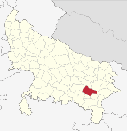 Location of Jaunpur district in Uttar Pradesh | |
| Country | India |
| State | Uttar Pradesh |
| Administrative division | Varanasi |
| Headquarters | Jaunpur, Uttar Pradesh |
| Tehsils | Badlapur, Jaunpur, Shahganj, Machhali Shahar, Mariahu and Kerakat |
| Government | |
| • Lok Sabha constituencies | Jaunpur(Lok Sabha constituency), Machhlishahr |
| Area | |
| • Total | 4,038 km2 (1,559 sq mi) |
| Population (2011) | |
| • Total | 4,476,072 |
| • Density | 1,100/km2 (2,900/sq mi) |
| • Urban | 489,456 |
| Demographics | |
| • Literacy | 71.55% |
| • Sex ratio | 1024 |
| Average annual precipitation | 987 mm |
| Website | Official website |
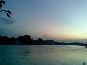
Jaunpur District is a district in the Varanasi Division in the state of Uttar Pradesh, India. Jaunpur lies in eastern part of state. Jaunpur City is situated on the bank of the Gomti River. It is located 228 km southeast of state capital Lucknow. The district have two Lok sabha seats, one Rajya Sabha and nine Vidhan Sabha seats. According to the 2011 census report Jaunpur has 1024 females on thousand males, the highest ratio in Uttar Pradesh.Main languages are Hindi, Urdu, Awadhi & Bhojpuri.
Historic places and sights
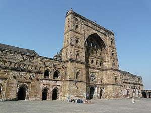
Atala Masjid

Firoz Shah III began the construction of the Atala Masjid in 1393 .Atala Masjid is model of Indo-Iran architecture.The Atala became a model for other Masjids in the Jaunpur district. Architecturally, it retained and advanced the element of monumentalism. The height of the Atala Masjid is over 100 feet (30 m). The perimeter is 248 feet (76 m). The entrance has three massive stone pylons. The central one consists of a high arch between two sloping towers. These are decorated with arched niches and stone screened windows.[1][2]
Jhanjhari Masjid
The Jhanjhari Masjid, on the north bank of the Gomti river, was built by Ibrahim in the Sipah locatility of Jaunpur township. It was a residence of Ibrahim himself, as well as a place for saints, scholars (pandits) and the army (who kept animals such as elephants, camels, horses and mules). After human destruction and flood damage, only the facade remains. This consists of an arch, 35 feet (11 m) high and 32 feet (9.8 m) wide. Some of the stones from this Masjid were used in the construction of the Shahi bridge.[2]
Masjid Jama ash Sharq (Jama Masjid)
The Jama Masjid is another of the Sharqi dynasty period, started by Ibrahim Shah Sharqi and after a number of construction phases, completed by Hussain Shah. It is located on the Shahganj road near the Purani bazaar in Jaunpur City. The size of the Masjid interior is 219 feet (67 m) x 217 feet (66 m). 27 steps climb to the top. There are four gates, one at each cardinal point. The eastern gateway was destroyed by Sikander Lodhi. The Masjid is decorated with Egyptian style engravings and lotus, sunflower and rose motifs.
Lal Darwaza Masjid
Lal Darwaza Masjid, Jaunpur|This Masjid was built in 1447 (as per inscription of this Masjid) at Begumganj, 1 mile (1.6 km) north of Jaunpur, during the reign of Sultan Mahmud Sharqi, by Queen Bibi Rajyi, dedicated to Maulana Sayyid Ali Dawood Kutubbudin, a celebrated saint (Maulana) of Jaunpur, whose descendent still live in the mohalla bazaar bhua Pandariba Jaunpur and mohalla Namaz Gah laldarwaza. The Masjid occupies 212 square feet (19.7 m2) x 188 square feet (17.5 m2) and has three entrances and a courtyard. It is also known as the "Red Portal Masjid".
Shahi Pul
The Shahi Pul is a bridge over the Gomti river at Jaunpur township. It was built by Khankhana in 1564 for Akbar. The bridge is 26 feet (7.9 m) wide. At each end were pillboxes to house stalls. On a square platform in the middle of the bridge, there is a large sculpture of a lion with an elephant underneath its forepaws. The statue originated in a Buddhist monastery. There is an associated mosque at Idgah on the Allahabad road.
Shahi Qila
In 1162, Firoz Shah III built the Shahi Qila (the imperial fort). The Kerar Kot fort once stood on the same site in Jaunpur township on the left (north) bank of the Gomti river. It contained a mosque and a spacious and stylish set of baths (hammam) installed by Ibrahim, Firoz's brother. The layout of the fort is an irregular quadrangle enclosed in stone walls. The walls surround raised earthworks. Most of the remains of the original structures are buried or in ruin.[3]
The main gates face east. The largest inner gate is 14 metres (46 ft) in height. Its external surface is set with ashlar stone.[3] A further, outer, gate was installed during the reign of the Mughal king, Akbar, under the patronage of the governor of Jaunpur, Min'im Khan in the 16th century. It is designed in the shape of a flanking bastion. The spandrels or spaces between the arches of the outer gate were decorated with blue and yellow tiles. Ornamental niches are built into the walls of the outer gate.
The two story residential and administrative building or "palace" was built in a square layout. An interior pillared verandah or aiwan overlooked the ground floor from the first.
The mosque or masjid is likely the oldest building in Jaunpur township. It was a simple arcade of about 39.40 metres (129.3 ft) x 6.65 metres (21.8 ft).
It was supported by pillars in the Bengali style. There are three low central domes and no minars. (There are two nearby stone pillars instead).[3][4][5]
Samrat Singh Kapurpur
Thakur Samrat Singh Kapurpur Durgvanshi Rajput From Kapurpur Jaunpur.
Geography
hy
Situation of Jaunpur district | |
|---|---|
The district of Jaunpur is situated in the North-West part of Varanasi Division.Its attitude varies from 261 ft to 290 ft. above Sea Level.
Rivers
Gomti and Sai are its main parental rivers. Besides these, Varuna, Basuhi, Pili. Mamur and Gangi are the smaller rivers here. The rivers Gomti and Basuhi divide the district into nearly four equal landmasses.Jaunpur district is often affected by the disaster of floods.[6]
Climate
Jaunpur district has a climate consistent with that of the Northern Plain and Central Highlands including the Aravalli range, hot semi-arid eco-region 4.3 and hot dry ecoregion 9.2. The temperature varies between about 4 °C (39 °F) and 44 °C (111 °F).[7] The annual normal rainfall is 1,098 millimetres (43.2 in). The monsoon season occurs from the third week of June to the first week of October. Normally, there are 46 rain days per year of which 31 occur in the monsoon season. The district regularly suffers drought and pestilence.[8]
Topography
The topography of the district is a flat plain undulating with shallow river valleys. The main permanently flowing rivers are the Gomti and the Sai.[9] The rivers of Jaunpur flow from northwest to southeast and the land slopes in the same direction. Thus, there is a more elevated area in the northwest and a less elevated area of land in the south east.[10]
Geology
Beneath the surface of the district of Jaunpur, is a thick mantle consisting of the quaternary sediments (silt, sand and clay) of the Ganga river system. Below is vindhya range bedrock. Mineral deposits are rare but there is limestone as a conglomerate kanker in nodular and block forms. The lime can be used in building. Earthquakes have been recorded, the largest in 1927 and 1954.[10]
Economy
District's main economical activity is agriculture and allied sector. Jaunpur is fastest developing area in eastern uttar pradesh with skill development, quality education and good infrastructure .
Agriculture
The main field crops of Jaunpur district are: rice, maize, pigeon pea, pearl millet, blackgram wheat and chickpea. Other crops are onion and potato and crops for fodder. The crops are grown with both rainfall and irrigation. There are cattle (both local low yielding and crossbred), and local low-yielding buffalo as well approximately 29% of Jaunpur's population is employed.Approximately 40% of those employed work in manufacturing, 26% work in trade and commerce, 19% work in other services, 8% work in transport and communication, 4% work in agriculture, 2% work in construction, and 2% are marginal workerss goats, sheep, backyard chickens and pigs and occasional dairy farms. There are 43 government reservoirs and many more private water sources.[8] At Gujartal lake, 2 miles (3.2 km) west of Kheta Sarai, pisciculture is conducted.
Industry
There is little heavy industry in Jaunpur. The Varanasi Jaunpur highway allows for some industrial economic development. A cotton mill was operational near Karanja Kala but has now been replaced by a medical college (Under construction) and there are some textile manufacturers. Other manufactured products include perfume (jasmine oil and attar) and incense, furniture, carpets, chemical fertiliser and cement. Tertiary and service industries include repair workshops, print shops and internet cafes.[9][11][12][13] There is a special economical zone located at Allahabad road near Mungra Badshahpur the Sathariya Industrial area or SIDA. Although all units of SIDA is not in function but maximum are doing work. Jaunpur have problem of infrastructure development. Like many other districts of eastern uttar pradesh Jaunpur have poor road quality and lack of electricity supply. National highway number 56 between Lucknow and Varanasi cross from Jaunpur.
List of theatres
- Kamala Talkies (Olandganj, Jaunpur)
- Ram Chitra Mandir (Sipah, Jaunpur)
- Ashok Talkies Jaunpur
Colleges and Schools
- Tilakdhari Singh Snatakottar Mahavidyalaya (T.D.P.G College)
- Raja Shri Krishna Dutt P.G. College, JAUNPUR
- Mohd.Hasan PG College, Jaunpur [14]
- B R P Inter College Jaunpur
- Dr. Akhtar Hasan Rizvi Shia Degree College, Jaunpur
- Mukteshwar Prasad Mahavidyalaya, Jaunpur
- Fareedulhaq memorial digree college Sabrahad
In 2011, an official census was made in Jaunpur district. It recorded a population of 4,476,072 of which 2,258,437 were female and 2,217,635 male. Jaunpur district has population density of 1,113 persons per km2.Between 2001 and 2011, the population of Jaunpur district grew 14.89%. Literacy increased from 59.84 to 73.66 percent. In 2011, 86.06 percent of men were literate and 61.7 percent of women.Children under six years formed 14.37% of the population.
Jaunpur ranks 7th in terms of population in the state and ranks 1st in terms of sex ratio (1,024). There are 663,513 households in the district accounting for 2% of the total households in the U.P. The average size of households in the
district is 6.8 persons.Urban population in the district is only 7.7% of total population[15]
Schools
It has many C.B.S.E. affiliated and 1 I.C.S.E. affiliated schools.
C.B.S.E. Board schools-
- Dr. Rizvi Learners Academy
- Prasad International School]]
- St. Patrick's Sr. Sec. School [16]
- Umanath Singh Hr. Sec.School:
- R.N.Tagore Sr. Secondary School Sukkhipur,JAUNPUR
- Savitri Convent High School
- Maa Durga Ji Sr. Sec. Vidyalaya
- St. Joseph,
- Radhika Bal Vidya Mandir [17]
- Blossoms, etc.
- S.S.Public Scho
- Eden Public School Sabrahad Jaunpur
I.C.S.E. board school-
- St.John's School,Siddiqpur,Jaunpur
Notable People
- Scientist Lalji Singh Father of Indian DNA fingerprinting
- Acharya Ramamurti an Indian social activist (gandhian) and educationist
- Dr. Mohammad Akram Nadwi Dean faculty of Islamic studies Oxford university London
- Ravi Kishan Bollywood actor
- Parasnath Yadava Ex MP and Ex Cabinet minister of UP Government
- Dr. Indu Prakash Singh Philosopher, economist, politician and former diplomat with the Indian Foreign Service
- Jagmohan Yadav IPS ex DGP UP Police
- Justice Ashok Bhushan a Judge at the Supreme Court of India and was 31st Chief Justice of Kerala High Court
Governance
Divisions
Within the district, there are 2 national lower house constituencies, Lok Sabha, of which Jaunpur constituency is entirely in the district, and 9 state lower house constituencies, Vidhan Sabha. Jaunpur district has six administrative subdivisions (Tahsils).

Tahsils
Development Blocks
Jaunpur district is further divided into twenty-one "development blocks".
- Sondhi (Shahganj)
- Suithakala
- Khuthan
- Karanja Kala
- Badlapur
- Maharajganj
- Sujanganj
- Baksha
- Mungra Badshahpur
- Machhali Shahar
- Mariahu
- Barsathi
- Rampur
- Ramnagar
- Jalalpur
- Kerakat
- Dobhi
- Muftiganj
- Dharmapur
- Sikrara
- Sirkoni
Thanas
There are also twenty-six police districts (Thanas).
- Kotwali
- Sadar
- Line Bazar
- Zafarabad
- KhetaSarai
- Shahganj
- Sarpatahan
- Kerakat
- Chandwak
- Jalalpur
- Sarai Khwaja
- Gaura Badshahpur
- Badlapur
- Khuthan
- Singra
- Baksha
- Sujanganj
- Maharajganj
- Mungra Badshahpur
- Pawara
- Machhlishahr
- Meerganj
- Sikrara
- Mariahu
- Rampur
- Barsathi
- Nevadhiya
- Sureri
- Baserawan
- Kaserawan
- Janghai
References
- ↑ Krishna Chaitanya (1987). Arts of India. Abhinav Publications. ISBN 978-81-7017-209-3.
- 1 2 "Atala Masjid" Jaunpur City website. Accessed 5 May 2012
- 1 2 3 "Jaunpur Fort," Archaeological Survey of India website. Accessed 7 December 2013.
- ↑ Yasin M. and Yasin M. (Ed.)"Reading in Indian History." Atlantic Publishers & Distributors, 1988. p66. Accessed at Google Books 6 December 2013.
- ↑ Asher C. B. "Architecture of Mughal India, Part 1, Volume 4. From "The New Cambridge History of India." Cambridge University Press, 1992 ISBN 0521267285, 9780521267281. p88 Accessed at Google Books 6 December 2013. Akriti Shukla(Gupta ji).
- ↑ http://jaunpur.nic.in/abtJaunpur.html
- ↑ National Informatics Centre "Jaunpur official website." Government of India. Accessed 3 December 2013.
- 1 2 "Agricultural contingency plan for Jaunpur." Government of India. November 2013. Accessed 3 December 2013.
- 1 2 Ministry of Micro, Small and Medium enterprises "A brief industrial profile of Jaunpur district." Government of India. Date not stated. Accessed 3 December 2013.
- 1 2 Prasad G. "Progress in Nanotechnology." Discovery Publishing House. 2008. Vol 2. pp 68-71. Accessed at Google Books 4 December 2013.
- ↑ "Varanasi city guide" Eicher Goodearth Limited, 2002 ISBN 8187780045, 9788187780045 p 182. Accessed at Google Books, 6 December 2013.
- ↑ Ram R. "Agricultural development: command area approach." Abhinav publications 1993. p88. Accessed at Google Books 4 December 2013.
- ↑ Sharma S. "India - a travel guide." Diamond Pocket Books (P) Ltd., 2008. ISBN 8128400673, 9788128400674. p248. Accessed at Google Books 6 December 2013.
- ↑ http://mhpgcollegejnp.com/
- ↑ District Census
- ↑ http://www.stpatrickschooljnp.org/
- ↑ http://rbvm.in/
External links
| Wikivoyage has a travel guide for Jaunpur. |
| Wikisource has the text of the 1911 Encyclopædia Britannica article Jaunpur. |