Khargone
| Khargone | |
|---|---|
| City | |
 Nagar Palika Head Office And Town Hall | |
 Khargone Location in Madhya Pradesh, India | |
| Coordinates: 21°49′12″N 75°37′07″E / 21.82°N 75.6187°ECoordinates: 21°49′12″N 75°37′07″E / 21.82°N 75.6187°E | |
| Country |
|
| State | Madhya Pradesh |
| District | Khargone |
| Region | Nimar |
| Elevation | 258 m (846 ft) |
| Population (2011) | |
| • City | 106,454 |
| • Rank | 23rd (in Madhya Pradesh state) |
| • Urban[1] | 215,000 |
| • Metro[2] | 133,368 |
| Languages | |
| • Official | Hindi and English |
| • Regional | Hindi and Nimadi dialect of Hindi |
| Time zone | UTC+5:30 (IST) |
| PIN | 451001 |
| Telephone code | 07282 |
| Vehicle registration | MP 10 |
| Sex ratio | 1000/945 ♂/♀ |
| Literacy Rate | 80.63%[3] |
| HDI | High[4] |
| Climate | Cwa / Aw (Köppen) |
| Precipitation | 914 mm (36.0 in) |
| Avg. annual temperature | 26.0 °C (78.8 °F) |
| Avg. summer temperature | 40 °C (104 °F) |
| Avg. winter temperature | 21 °C (70 °F) |
| Website |
www |
Khargone is a city in Madhya Pradesh state of in India. It is the administrative headquarters of the Khargone district (formerly known as West Nimar). Several major administrative offices of the Khargone District, including the collectorate, police, telecom and various other government organizations are located in the city. The city is situated at the bank of Kunda river and is famous for its cotton and chilly (chili pepper) production. It is also known for Navgraha Mandir, a temple devoted to the nav grahas (nine planets). Khargone topped the nation in municipality and received a national award for 'India's Fastest Moving City' under a population of two lakh. City ranked the 15th cleanest city in India in Swachh Survekshan 2018[5] and ranked 17th cleanest city in India in Swachh Survekshan 2017.[6] Khargone is the 23rd biggest city in the state of Madhya Pradesh.
History
According to mythology, the name "Nimar" was derived from the word "Nimarya" (निमार्य), which signifies that the land had belonged to both the Aryas and the non-Arya. However, according to another myth, the word "Nimar" has been associated with the place due to the presence of a large number of Neem trees.[7] At different times in history, the area was ruled by the Kingdoms of Haihayas (हैहय) of Maheshwar, Parmar of Malwa, Ahirs of Asirgarh,[8] Muslims of Mandav, Peshwa, Mughals and Marathas. After the formation of the state of Madhya Pradesh on 1 November 1956, the district came into existence as West Nimar (पश्चिम निमाड़). Later (on 25 May 1998) due to certain administrative needs, the district was divided between Khargone and Barwani.
Near 17 Kilometer, "OON" is a very old village and here 99 Bhumija Style Temples; made by emperor Ballaleshwar. OON is also famous for MahaLakshmi and Jain Temple.
The population of the district was estimated to be about 1,872,413, according to the census of India 2011.
Geography
Khargone is located in the south-west border of Madhya Pradesh, 258 metres (846 ft) above sea level. It is spread over an area of 8,030 square kilometres (3,100 sq mi). Towards the north it borders Dhar, Indore and Dewas districts. Towards the south, it borders Maharashtra, in the east, Khandwa&Mundi and Burhanpur and Barwani in the west. Khargone is in the middle of the Narmada River valley with the Vindhyachal mountain range situated in the north and Satpura in the south. The River Narmada flows along a path of 50 kilometres (31 mi) inside the district. Veda and Kunda are the other two main rivers in the district.

Khargone is 90 km (56 mi) away from Barwani, 80 km (50 mi) from Khandwa and 140 km (87 mi) from Indore120 km (75 mi) from Mundi. The district is connected to the cities of Indore, Khandwa, Mundi, Barwani, Dhar, Jhabua, Jalgaon and Dhulia by road. The Khandwa-Vadodara National Highway (NH#347B) and Chittorgarh-Bhusawal National Highway (NH#347C) passes through the City. The Agra-Mumbai National Highway (NH#3) passes through the district. In the eastern part, the district has a meter-gauge railway line connecting Delhi-Jaipur-Indore-Khandwa-Hyderabad. Important stations on this route include Barwah and Sanawad. The nearest broad gauge line railway station is Khandwa Junction. The nearest airport is located at Indore & Khandwa.
Demographics
Khargone is growing fast as a city, and it now includes many villages, such as Jetapur. As of 2011 India census,[9] Khargone had a population of 1,16,150. While males constitute 51.44% of the population, females average 49.46%. Khargone has an average literacy rate of 80.9%. This is higher than the national average of 74.04%: male literacy is 87.84%, and female literacy is 75.73%. About 13% of the population is under 6 years of age.
Economy
Economically, Khargone is dependent on agriculture, with several other industries developing in the area.
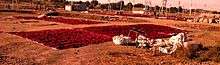
The major cash crops of Khargone District are cotton, soybean and chilly (or "chili pepper"). The district is India's biggest cotton-producing region. There are various cotton processing units (spinning) in the cooperative sector and private sector. One of the major spinning unit is JawaharLal Nehru Sahakari Soot Mill, situated on Julwania Road. It is a cooperative sector society. The red chilly is exported abroad. A famous mandi of chilly at Bedia is located about 50 km from Khargone and the famous Sendhwa cotton hub is just 70 km from district headquarters.
Culture
Various cultural activities are held throughout the year. Residents of the city, belonging to different religions, celebrate various festivals such as Diwali, Dussehra Raksha Bandhan Navratri Ganeshotsav Nag panchamiNag Dipawali Gudi Padwa Sanjha Mata parv Devotthan Ekadashi Eid, Holi, Christmas etc. with harmony and peace. Other than the regular festivals, certain festivals are local to the region such as Gangore, which is celebrated by many people.
There are many other cultural events held in the city throughout the year. There are various book fairs, art fairs, etc. Many local festivals celebrated with joy and happiness, such as 'Nag Panchami' (a day celebrated for snakes which are respected and worhipped like a god in Hindu mythology), or Bhagoriya (a festival celebrated by tribal people in the region).
Shree Navgrah Mela
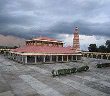
Shree Navagrah Mela is an annual fair held during the months of January and February. It lasts between 20 and 25 days. The fair is held at the Mela Grounds situated near the banks of river Kunda, near the famous Navagraha temple. The name 'Navgraha Mela' is itself derived from the Navagraha mandir (temple), which is the temple devoted to the nine planets (Nav-grahas) and the god 'Sun'. There are various attractions and events held during the fair, such as 'circus' or 'moving theatres' and amusement rides for children and youth.
A significant feature of the event is a large market with hundreds of stalls selling a wide variety of goods. A large amount of business is generated by this fair every year in Khargone. Food and cuisine is also an important attraction, with many different local cuisines available.
A separate cattle and livestock market also takes place during the fair where various animals such as bulls, cows, goats and calves are brought from nearby villages and areas for exchange and sale.
Nimar Utsav
Nimar Utsav is very popular event held in Nimar. As the name suggests, it is the 'utsav' (celebration) or the festival held every year in the holy city of Maheshwar at the banks of Narmada River. During this event, different arts and cultural programs are held, such as displays of different dance forms and the cultural aspects of Nimar. Many tourists attend the event every year.
Shiv Dola
This is the most popular event held in the city of Khargone. A huge procession of Siddhanath Mahadev (Lord shiv) Going through the city on 2nd day of Vaishakh month. A large number of people take part in it, every year around 2 - 3 lakh people been the part of this local program.
Gangaur
Gangaur is a festival celebrated in Nimar region, along with North India, especially Rajasthan. Gangaur is colourful and one of the most important festivals of people of Nimar with great fervour and devotion by women who worship Gauri, the wife of Lord Shiva during March–April. It is the celebration of spring, harvest and marital fidelity. Gana is a synonym for Lord Shiva and Gaur which stands for Gauri or Parvati who symbolizes Saubhagya (marital bliss). The unmarried women worship her for being blessed with a good husband, while married women do so for the welfare, health and long life of their husbands and for a happy married life.
Weather
Khargone has a transitional climate between a tropical wet and dry climate and a humid subtropical climate. Three distinct seasons are observed: summer, monsoon and winter. Summers are extremely hot and dry in this region, lasting from mid-march to mid-June followed by the monsoon season. The temperatures in summer are usually above 40 °C (104 °F) during April–May. During these months when temperatures become very high, the dry and hot wind (locally known as "loo") blows in this area, widely affecting the local ecology. The temperature also remains quite high during the night.
The monsoon arrives in late June, with temperatures around 29 °C (84 °F) and about 36 inches (914 mm) rainfall. The rainy season is humid and has substantial rainfall. Local people are commonly affected by the flooding of river Kunda, which flows from outskirts of the city. Winters start in mid-November and are dry, mild and sunny. Temperatures average about 4–15 °C (39–59 °F), but can fall close to freezing on some nights.
| Khargone | ||||||||||||||||||||||||||||||||||||||||||||||||||||||||||||
|---|---|---|---|---|---|---|---|---|---|---|---|---|---|---|---|---|---|---|---|---|---|---|---|---|---|---|---|---|---|---|---|---|---|---|---|---|---|---|---|---|---|---|---|---|---|---|---|---|---|---|---|---|---|---|---|---|---|---|---|---|
| Climate chart (explanation) | ||||||||||||||||||||||||||||||||||||||||||||||||||||||||||||
| ||||||||||||||||||||||||||||||||||||||||||||||||||||||||||||
| ||||||||||||||||||||||||||||||||||||||||||||||||||||||||||||
Education
The district is served well by several educational institutes, comprising both the private and public sectors. There is a government post-graduate degree college in the city, with three engineering colleges, three pharmacy colleges, one pilot training college and two polytechnic colleges, along with several English and Hindi medium schools and colleges. These institutions offer degrees in both the science and the arts. This district is the best educational district in the Nimar region. Ranks of districts: 1) Khargone, 2) Khandwa, and 3) Barwani.
Public Schools
There are 2,605 primary schools (PS), 721 middle schools (MS), 73 high schools (HS) and 69 higher secondary schools (HSS) located in the district. The district also has five Kendriya Vidyalays (central schools). These include: Kendriya Vidyalaya (Khargone), Kendriya Vidyalaya (Barwah), Kendriya Vidyalaya (Badwani), Kendriya Vidyalaya (kasrawad), Modal school Badwani and Navoday Vidyalay Sanawad.
There are also several high schools. Among these:
- 1.Swami Vivekananda public HR Sec School Khargone
- 2. Vagdevi Vidyapeeth International School
- 3.Maharishi Vidya Mandir.(CBSE affiliation Number: 1030219)
- 4. St. Judes School(CBSE Affiliation Number: 1030166
- 5. Aaditya Vidya Vihar.CBSE affiliated.
- 6. Gokuldas Public School (CBSE Affiliation Number 1030212)
- 7. Saraswati Vidya Mandir
- 8. Priyadarshani Shikshaniketan.
- 9. Bal Shiksha Niketan
- 10. Devi Ahilya School of Excellence no. 1
- 11. Shri vaishnav vidhya mandir.
- 12.Devi Ahilya Govt. Boys Higher Secondary School no. 2.
- 13 Lotus children's school Gouridham Colony Khargone
- 14 Innovative Public School, in front of kendriya vidhyalaya, kasrawad road, khargone
- 15 Sanskar Shikshalay, Nutan Nagar
- 16 Govt. Boys Higher Secondary School, Gogawa
- 17 Avisans Public High School Jetapur, Khargone
- 18 saifiyah Higher Secondary School, khargone
- 19 The Creative Public Higher Secondary School
- 20 Devi Rukmani HR.S.School, Bistan Road Khargone
Colleges
There are various colleges[10] in the district. These are affiliated with Devi Ahilya Vishwavidyalay, Indore (University of Indore) and offer several graduate and postgraduate-level courses. The list includes:
- Shree Narayan Institute of Technology (SNIT)
- Jawaharlal Nehru Mahavidyalaya
- Jawaharlal Institute of Technology, Borawan
- Government Post Graduate Degree College
- Government Girls Degree College
- Shreeji Institute Of Technology and Management College
- Alma Computer Khargone
- Saikripa Academy Khargone
- Devi Rukmini college of Education
- Modak Institute of technology
Banks
Most of the dist. co-operative bank and national banks have branches in the city. Prominent ones include the jila sahkari kendriya bank Maryadit city branch near goul build, chouraha, main branch bus stand, tilak path branch, Pahadsinghpura branch, State Bank of India, the State Bank of Indore, the Bank of India, Punjab National Bank, the Bank of Maharashtra, Syndicate Bank and the Central Bank of India. Private banks such as HDFC, Axis Bank(Sanawad Road), ICICI, Union Bank, and Bank of Baroda have also opened branches. These branches are located in the Radha Vallabh market area.
Currently, Khargone has 30 -35 ATMs that belong to the State Bank of India, Axis Bank, HDFC bank, ICICI, Union Bank of India, Punjab National Bank, Bank of Maharashtra, Syndicate Bank, Bandhan Bank, IDBI Bank, Dena Bank, Central Bank of India, Jila sahakari kendriya bank maryadit, khargone and the Bank of Baroda.
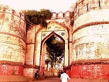
Tourist attractions
Temples in khargone District[11]
Maheshwar
It is said that there are more than 100 temples at Maheshwar, indicating the long history of Maheshwar. Main temples for visitors are Sahastararjun Temple near the holy river Narmada, Raj-Rajeshwar Mandir, Kashi Vishwanath Mandir, Chaturbhuj Narayan Mandir, Ahilya Mata's Chhatris, Rajwada, Chintamani Ganpati Mandir, Bada Ganpati temple, Pandharinath Mandir, Bhawani Mata Mandir, Gobar Ganesh Mandir, Banke Bihari, Anant Narayan Mandir, Khedapati Hanuman, Ram and Krishna Mandir. Baneshwar temple, Kaleshwar, Jwaleshwar and Narsingh Mandir are very good for nature lovers.
The recently built Ek mukhi Datta Mandir is situated in Jalkoti, Sahastradhara.
Dulhar, Niljhar and Bhapsi Falls nearest Jhirniya at Veda River ।
Nearby places
- Pavagiri Tirth
Shri Pavagiri Tirth is situated in Una or Oon. The temple was erected in 12th century during the period of Parmars.[12] It is said that Ballal, the king of Malwa committed to built 100 temples but died after completion of 99 temples giving this place the name Una (one less than 100). Gwaleshwar temple is dedicated to Shantinatha, the 16th Jain Tirthankar. Moolnayak of the temple is a 12 feet tall black colored idol of Lord Shantinath in standing posture with 8 feet tall idols of Lord Kunthunath & Arahnath on both sides.[13] Colossus of Lord Shantinath was installed in 1206(V.S. 1263). In Year 1934, 2 feet idol of Lord Mahaveer Swami in padmasan posture was excavated dating back to 1195(V.S. 1252). Many idol belonging 12th-13th century can be found here.[14] The temple has a dhamshala with bhojanalya.[15] The architecture of the temple is similar to that of in Khajuraho.[16] Temples of Mahavira, Sambhavnatha, Chandrprabhu are present near the main temple[17] Temple of manokamneswar hanuman at village surwa
Other places
- Khedi Khurd
- Sanawad
- Khandwa
- Kasrawad
- Bhikangaon
- Maheshwar
- Mandleshwar
- Kasrawad
- Dhamnod
- Dharampuri
- Rajpur
- Sendhwa
- Anjad
- Pandhana
- Barwaha
- Manpur
- Chopda
- Manawar
- Badi, Kasrawad, Khargone 38 km
- village surwa khargone 31
- tantya mama caves near jhirnya
Other Attractions
- Bawangaja (now in Barwani)
- Oon (14 km), famous for its Jain pilgrimage centres.[18]
- Nanheshwar (20 km), famous for its ancient Shiva temples.
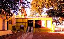
- The Navagraha temple, the ancient temple devoted to Navagraha, the nine (nava) major celestial bodies (Grahas) of Hindu astronomy.
- Sirwel Mahadev temple , an ancient temple, devoted to Lord Shiva, located 56 km south in the Satapuda mountain above 700 meter from the sea level, with a good connectivity from the city by road, this place is also famous for its waterfall on the river Kunda which is originated from here and there are few more water falls around this place, Sirwel Mahadev also surrounded by Jungle in Satapuda velly. It is a naturally beautiful place, especially in rainy season.
- Nagalwadi Shikhardham or Bhilat Dev Dham, located about 50 km from Khargone, westerly - little off road from Khargone to Badi Bijasan Mata Mandir, Sendhwa
- Bijasani Mata Temple, located around 20 from Khargone in North through Indore road. A beautiful place at the top of a small hill.
- Lula Baba Samadhi, located 10 km from the city in North. Dedicated to Sri Purnanand Swami Maharaj.
- Shri Santoshi Mata Temple ancient temple devoted to Goddess Santoshi, daughter of Lord Ganesha, temple is located at the bank of river Kunda 7 km southwest from the city. This place also has a small waterfall on the river.
References
- ↑ {{cite web|url=http://www.indiaonlinepages.com/population/madhya-pradesh-population.html%7C
- ↑ "INDIA STATS : Million plus cities in India as per Census 2011".
- ↑ "literacy rate".
- ↑ http://www.dif.mp.gov.in/mphdr%5CHDITable_E_1995.pdf%5Bpermanent+dead+link%5D
- ↑ https://www.swachhsurvekshan2018.org/Rankings/Morethan1Lakh. Missing or empty
|title=(help) - ↑ "Swachh Bharat rankings 2017: Here are the top 100 cities ranked on cleanliness". The Indian Express. 4 May 2017.
- ↑ "परिचय: जिला खरगौन (म.प्र.) भारत 451001".
- ↑ Mehta, BH (1984). Gonds of the Central Indian Highlands Vol II. Concept Publishing Company. p. 569. Retrieved 24 April 2016.
- ↑ . Census Commission of India (Provisional) https://www.censusindia.co.in/towns/khargone-population-khargone-madhya-pradesh-802284 (Provisional) Check
|url=value (help). Retrieved 2008-11-01. Missing or empty|title=(help) - ↑ http://khargone.nic.in/Education.htm
- ↑ http://www.khargone.nic.in/Places%20to%20Visit.htm
- ↑ https://books.google.co.in/books?id=loQkEIf8z5wC&pg=PA134&lpg=PA134&dq=Gwaleshwar+temple&source=bl&ots=ZSH3VjlCHr&sig=-lDiKtTWbY3PofLAy2QyytGML20&hl=en&sa=X&ved=0ahUKEwjAurTutarQAhUMKo8KHWq1AAwQ6AEILjAF
- ↑ https://books.google.co.in/books?id=crYOAAAAIAAJ&pg=PA747&lpg=PA747&dq=Gwaleshwar+temple&source=bl&ots=Go5k4MhA29&sig=h2_MtDXZSAeDmPm1hxz0hrltn60&hl=en&sa=X&ved=0ahUKEwjAurTutarQAhUMKo8KHWq1AAwQ6AEIRDAJ#v=onepage&q=Gwaleshwar%20temple&f=false
- ↑ http://jainteerth.com/madhya-pradesh-m-p-jain-teerth/shri-digamber-jain-siddha-kshetra-pavagiri-una/
- ↑ http://jain.org.in/tirth-Pawagiri%20Una%20(oon),%20M.%20P.html
- ↑ http://jainsite.com/jain-tirth/pavagiri-tirth/
- ↑ http://www.jainglory.com/research/gwaleshwar
- ↑ http://www.khargone.nic.in/Oon.htm
External links
| Wikimedia Commons has media related to Khargone. |
- Official Website of Khargone District
- website for Navagraha mandir khargone
- Non profit organizations khargone