Karauli
| Karauli | |
|---|---|
| city | |
 Karauli Location in Rajasthan, India  Karauli Karauli (India) | |
| Coordinates: 26°30′N 77°01′E / 26.5°N 77.02°ECoordinates: 26°30′N 77°01′E / 26.5°N 77.02°E | |
| Country |
|
| State | Rajasthan |
| District | Karauli |
| Founded by | Raja Bijaipal |
| Government | |
| • Body | Nagar Parishad |
| Elevation | 275 m (902 ft) |
| Population (2011) | |
| • Total | 82,960 |
| Languages | |
| • Official | Hindi |
| Time zone | UTC+5:30 (IST) |
| PIN | 322241 |
| Vehicle registration | RJ 34 |
| Website |
karauli |
Karauli (also formerly spelled Karoli or Kerowlee) is a town located in the Indian state of Rajasthan. The town is the administrative center of Karauli District, and was formerly the capital of the erstwhile princely state of Karauli. Karauli District comes under Bharatpur Divisional Commissionerate.
Geography
Karauli is located at 26°30′N 77°01′E / 26.5°N 77.02°E.[1] It has an average elevation of 275 metres (902 ft).
History
Earlier, Karauli, along with Alwar, was part of the Matsya kingdom, according to the legend of Mahabharata. The modern princely state Karauli was founded in about 995 by Raja Bijai Pal, who was a [[Jadaun|Jadon Rajput]An ethnographical hand-book for the N.-W. provinces and Oudh By William Crooke</ref>[2] or Ahir[3][4][5] ruler, who is claimed to be 88th in descent from the Hindu god Krishna.[5]. The Jadu Rajputs are descendants of Lord Krishna, founded in 900AD by Raja Brahm Pal. The town itself dates from 1348, and is located in a geographical setting naturally defended by ravines on the north and east, and is further protected by a great wall.[6] His Highness the Maharaja maintains a military force of 281 cavalry, 1640 infantry, and 56 guns, and is entitled to a salute of 17 guns (as of 1892). The Britishers later occupied it, and they ruled up to 1947. The Maharaja's palace is a handsome block of buildings, some of them dating to the mid-18th century.[6] Karauli State was founded by Maharaja Arjun Dev pal in 1346 AD, but now the Gurjar and Meena castes dominate Karauli.
Geographical
Area - 674 km2
Longitude - 76° 37′ E to 77° 13′ E
Latitude - 26° 2′ N to 26° 21′ N
Highest Point - 475 m
Climate
Subtropical, dry climate with distinct winter, summer and monsoon.
Highest Temperature - 49.0° C (May–June)
Lowest Temperature - 5.0° C (January)
Average Rainfall - 800 mm
Monsoon - July to September ( Visit Season )
Monuments
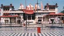
Shri Mahavirji
.jpg)
Shri Mahavirji is one of the miraculous pilgrimages of Jains. This pilgrimage situated at Hindaun Block in Karauli district. Built at the bank of a river, this pilgrimage is a prominent centre of devotion for Jain devotees. Temple is famous for iconic idol of Lord Mahavira, the principal deity of the pilgrimage temple. Jaipur rulers provided grants for the management of this temple.
Shri Mahavirji is vast & magnificent ornamented with so many pinnacles. This temple is surrounded by Dharmashalas. Exterior & interior walls of the temple are richly decorated with beautiful carvings and golden paintings to improve the attraction, impression and glory of temple. Shantinath Jinalaya is also present near this temple, the main attraction of the temple is an imposing 32 ft high image of Lord Shantinath, the 16th Jain tirthankar.
Kaila Devi Temple
Kaila Devi (Goddess) temple is located on the banks of the Kalisil river in Karauli district. The temple is devoted to the tutelary deity, goddess Kaila, of the erstwhile princely rulers of the Karauli state. It is marble structures with a large courtyard of a checkered floor.In one place are a number of red flags planted by devotees. The place is also famous for its fair held during the dark half of Chaitra (March–April), which lasts for a fortnight.
In the sanctum sanctorum, there are two idols. The idol of Kaila Devi is slightly reclined as the neck of the goddess is bend. The idols are very old and they are made of the locally available stone. The temple is a fine example of medieval architecture. The shikhar is very high, like a pyramid. The Jagmohan or the prayer hall is also the same. The ornamental work, engraving and encarving have been done on walls and pillars. The temple stands on a rocky elevation.
Demographics
As of 2011 India census,[7] Karauli had a population of 82,960. Males constitute 53% of the population and females 47%. Karauli has an average literacy rate of 53%, lower than the national average of 59.5%. Male literacy is 65%, and female literacy is 41%. In Karauli, 19% of the population is under 6 years of age.
References
- ↑ "Maps, Weather, and Airports for Karauli, India".
- ↑ An Ethnographical Hand-book for the N.-W. Provinces and Oudh.
- ↑ A History of the Sikhs from the Origin of the Nation to the Battles of the ...
- ↑ Cunningham, Joseph Davey; Garrett, H. L. O. A History of the Sikhs from the Origin of the Nation to the Battles of the Sutlej. Asian Educational Services. p. 7. ISBN 9788120609501. Retrieved 24 April 2016.
- 1 2 Cunningham, Joseph Davey; Garrett, H. L. O. A History of the Sikhs from the Origin of the Nation to the Battles of the Sutlej. Asian Educational Services. p. 7. ISBN 9788120609501. Retrieved 24 April 2016. Quote:"The little chiefship of Karauli.........The raja is admitted by the genealogists to be of the Yadu or lunar race, but people sometimes say that his being an Ahir or cowherd forms his only relation to krishna, the pastoral Apollo of the Indians."
- 1 2

- ↑ "Karauli District Population Census 2011, Rajasthan literacy sex ratio and density".
External links
| Wikivoyage has a travel guide for Karauli. |
- Karauli founded by Maharaja Arjun Dev Pal
- Most of the population migrate from Karauli
- Karauli District website
- Genealogy of the ruling chiefs of Karauli
| Outline |  | ||||||||||||||
|---|---|---|---|---|---|---|---|---|---|---|---|---|---|---|---|
| Governance | |||||||||||||||
| Divisions and districts |
| ||||||||||||||
| Major cities | |||||||||||||||
| Related templates |
| ||||||||||||||