Dumka
| Dumka | |
|---|---|
| Town | |
 Dumka Location in Jharkhand, India  Dumka Dumka (India) | |
| Coordinates: 24°16′N 87°15′E / 24.27°N 87.25°ECoordinates: 24°16′N 87°15′E / 24.27°N 87.25°E | |
| Country |
|
| State | Jharkhand |
| District | Dumka |
| Region | Rarh region |
| Government | |
| • Type | Municipality |
| Area | |
| • Total | 4,404.02 km2 (1,700.40 sq mi) |
| Elevation | 137 m (449 ft) |
| Population (2017) | |
| • Total | 47,584 |
| • Density | 300/km2 (800/sq mi) |
| Languages | |
| • Official | Hindi |
| • Other important | Santali, Bengali, Ho |
| Time zone | UTC+5:30 (IST) |
| PIN | 814101 |
| Telephone code | 06434 |
| Vehicle registration | JH-04 |
| Sex ratio | 974 ♂/♀ |
| Website |
dumka |
Dumka, headquarters of the Dumka district and Santhal Pargana region, is a City in the state of Jharkhand, India. It was made the headquarters of the Santhal Pargana region, which was carved out of the Bhagalpur and Birbhum district after the Santal Hool of 1855. Dumka was carved out of the southern part of Bihar along with 18 other Districts on 15 November 2000 to form Jharkhand as 28th State of India. Dumka is a peaceful and green city is also sub-capital of Jharkhand. The nearest important cities are Rampurhat and Deoghar.
Etymology
There are two theories on how Dumka got its name. The first one suggests that Dumka's name derives from the Santali word sumk for "shunted" or "small," because during the British Raj, it was a small town compared to Rampurhat and Bhagalpur .
The other is that Dumka derives its name from the Persian word damin-i-koh, which means 'skirts (an edge, border or extreme part) of the hills'. The Mughals assigned this name to the town and its vicinity on account of the presence of hillocks and undulating terrain.
History
- Stone-age: On the basis of tools unearthed the original inhabitants appear to be the Mon-khmers and the Mundas.
- Early History: The earlier inhabitants of the present-day district of whom there is same record, it appears, were the Paharias (for example, the Maler and Sauria Paharias). The Greek traveler Megasthenes identified these people as Mallis. He referred to the Sauria Paharias as savars of Odisha.
- Medieval History: Due to inaccessibility of the area caused by the cliffs of the Rajmahal Hills, it was a place of strategic economic importance, with a fort at Teliagarhi.
- After the 1539 victory of Sher Shah Suri at Chousa, the area fell into the hands of the Afghans, but it was soon lost to the Mughals under Akbar when Hussain Quli Khan was made viceroy of Bengal.
- British Period (Raj): The English representative, Dr. Gabriel Bokgliton, procured a farman from Shah Jahan.
- 1742-1751: The area of Dumka close to Rajmahal witnessed frequent inroads by the Marathas under Raghoji Bhosle and Peshwa Balaji Rao.
- 1745: Raghoji Bhosle entered Rajmahal via the hills and jungles of Santal Pargana. The early stay of the English was spent in subduing the Paharias.
- 1769: Dumka remained a Ghatwali police post under Birbhum District of Bengal.
- 1775: Dumka was transferred to Bhagalpur Division.
- 1865: Dumka was made an independent district after being carved out of Bhagalpur.
- 1872: Dumka was made headquarters of the whole district of Santal Pargana.
- 1889: Paul Olaf Bodding started his service in India (Dumka/Benagaria) after Lars Olsen Skrefsrud, and Bodding created the first alphabet for the Santhals. The NELC-church was created as a Lutheran Church in this area - before the Catholics had established a mission in this area at all.
- 1902: The first municipality was established.
1920: Motor cars and buses were introduced.
- 1952: The Apostolic Prefecture of Malda was erected. In 1962, it was promoted to the Roman Catholic Diocese of Dumka.
- 1983: Dumka was made the divisional headquarters of Santhal Pargana.
- 2000: Dumka became the sub-capital of Jharkhand.
- 2011: Dumka is connected with the newly built Jasidih - Dumka railway line.
- 2012: Intercity express to Ranchi started via Jasidih.
- 2017: Jharkhand opens pilot training center in Dumka
Population
Demographics
As of 2011 India census,[1] Dumka is a Nagar Parishad city in district of Dumka, Jharkhand. The Dumka city is divided into 23 wards for which elections are held every 5 years. The Dumka Nagar Parishad has population of 47,584 of which 25,364 are males while 22,220 are females as per report released by Census India 2011.
Population of Children with age of 0-6 is 5371 which is 11.29 % of total population of Dumka (Nagar Parishad). In Dumka Nagar Parishad, Female Sex Ratio is of 876 against state average of 948. Moreover, Child Sex Ratio in Dumka is around 891 compared to Jharkhand state average of 948. Literacy rate of Dumka city is 89.92 % higher than state average of 66.41 %. In Dumka, Male literacy is around 93.46 % while female literacy rate is 85.87 %.
Religion, languages and culture
Dumka District contains many popular Hindu temples, such as Basukinath, Sirshanath, Maluti Mandir, Shiv Pahar and Dharamsthana. Crowds visit these places during the month of Sawan.
Chootonath is also very famous place of local KRAM KAND and MUNDAN.
The Catholic minority is served by its own Roman Catholic Diocese of Dumka.
Besides the national official language Hindi, Santali, Bengali are important.
Geography
Dumka is located at 24°16′N 87°15′E / 24.27°N 87.25°E.[2] It has an average elevation of 137 metres (449 feet). The Dumka district has an area of 3716.02 km2 and consists of only one subdivision, namely, Dumka. Under the Dumka subdivision, there are 10 blocks, namely, Dumka, Gopikander, Jama, Jarmundi, Kathikund, Maslia, Ramgarh, Ranishwar, Ranibahal, Shikaripara and Saraiyahat.
Places adjacent to Dumka | |
|---|---|
Physiography
Dumka has a predominantly undulating terrain with hard rocks under the ground. The entire district has a topography with high ridges and valleys bounded by mountains and rivers. The soil fertility is poor due to extensive erosion, acidity and low retaining capacity.
Climate
Dumka has a humid subtropical climate (Köppen climate classification Cwa), with warm, wet summers and mild winters.
| Climate data for Dumka | |||||||||||||
|---|---|---|---|---|---|---|---|---|---|---|---|---|---|
| Month | Jan | Feb | Mar | Apr | May | Jun | Jul | Aug | Sep | Oct | Nov | Dec | Year |
| Record high °C (°F) | 33.3 (91.9) |
35.6 (96.1) |
42.8 (109) |
46.3 (115.3) |
48.3 (118.9) |
45.2 (113.4) |
41.5 (106.7) |
38.6 (101.5) |
38.1 (100.6) |
37.6 (99.7) |
35.8 (96.4) |
31.2 (88.2) |
48.3 (118.9) |
| Average high °C (°F) | 25.9 (78.6) |
28.9 (84) |
34.3 (93.7) |
38.4 (101.1) |
37.5 (99.5) |
35.5 (95.9) |
32.7 (90.9) |
32.5 (90.5) |
32.9 (91.2) |
33.0 (91.4) |
30.5 (86.9) |
27.0 (80.6) |
32.4 (90.4) |
| Average low °C (°F) | 10.2 (50.4) |
13.2 (55.8) |
17.4 (63.3) |
22.3 (72.1) |
23.9 (75) |
24.7 (76.5) |
24.1 (75.4) |
23.7 (74.7) |
23.6 (74.5) |
21.0 (69.8) |
16.0 (60.8) |
11.1 (52) |
19.3 (66.7) |
| Record low °C (°F) | 1.7 (35.1) |
1.8 (35.2) |
5.8 (42.4) |
13.8 (56.8) |
14.5 (58.1) |
17.8 (64) |
13.4 (56.1) |
16.8 (62.2) |
13.8 (56.8) |
11.8 (53.2) |
4.8 (40.6) |
2.8 (37) |
1.7 (35.1) |
| Average precipitation mm (inches) | 9.0 (0.354) |
15.0 (0.591) |
21.0 (0.827) |
35.0 (1.378) |
72.0 (2.835) |
198.0 (7.795) |
343.0 (13.504) |
293.0 (11.535) |
273.0 (10.748) |
116.0 (4.567) |
9.0 (0.354) |
7.0 (0.276) |
1,391 (54.764) |
| Average rainy days | 1.5 | 2.3 | 2.2 | 2.8 | 6.3 | 11.3 | 18.9 | 16.9 | 14.1 | 5.7 | 1.1 | 0.8 | 83.9 |
| Average relative humidity (%) | 60 | 53 | 47 | 50 | 60 | 73 | 83 | 83 | 81 | 74 | 65 | 62 | 66 |
| Source: NOAA (1971-1990)[3] | |||||||||||||
Politics
The first Chief Minister of Jharkhand, Babulal Marandi, hailed from Dumka constituency. In 2000, when Jharkhand was carved out of Bihar, NDA came to power in Jharkhand with Marandi as the Chief Minister. However, he had to resign and make way for Arjun Munda (BJP) for the post in 2002 following pressure exerted by coalition allies primarily JD(U). Recently, he formed his own party with Stephan Marandi, another political leader of the state.
Shibu Soren is another familiar and famous politician associated with Dumka. His political career has been mired in controversies, starting since Indira Gandhi's prime ministership. Recently, he was sent to Dumka jail after being convicted of murdering his private secretary Shashinath Jha. But, the Delhi High Court acquitted him of the murder charge of his private secretary due to lack of evidence. A number of cases are still pending before the Jamtara Session Court and some of the other courts of the Jharkhand. He is currently holding the place of MP from Dumka constituency, while his son Hemant Soren was representing Dumka in the Legislative Assembly and is deputy CM of the state.
In 2014, state election BJP coalation got majority in Assembly and Raghubar Das become the Chief Minister of Jharkhand, another familiar and famous politician associated with Jamsedhpur.
Education
Zila School, National School, Govt. Girls School and Dumka Central School provide education till +2 level. Other reputable schools which provide education through secondary level are St. Joseph's School (Bakshi Bandh Road), N.E.L.C. Don Bosco School, Decent Children School, Phasidangal, Dumka - Jharkhand with (cbse curriculum from Nur-10th)...,S.S. Vidya-Vihar, Sido Kanhu High School, St. Teresa High school (for girls) and Holy Child, and St. Joseph's High School Guhiajori(https://www.facebook.com/st.JosephsSchoolGuhiajori) , Bal Bharti . St. Joseph's high school, holy child and Don Bosco are ICSE schools in dumka. Now a day dumka has become a education hub .. there are many talented teachers in every field .. be it intermediate or competitive examination such as Rajesh sir for maths(+2) rantosh sir for competition(ssc) and many more ...
Other schools of similar repute include Ananda Marga School (in Kurwa), Modern Sainik School, Green Mount Academy and New Life Academy (in Kathikund block). Santhal Pargana College and A. N. College ( Aditya Narayan College) run under the Sido Kanhu Murmu University. S. P. College offers undergraduate, graduate and postgraduate courses in various disciplines of science, arts and commerce and also have 7 big Hostel for college students . Recently the B.Ed. course was also introduced. An IGNOU study center provides for distance learning education in various certificate, diploma, graduation and postgraduate courses. Another well known university is Birsa Agricultural University which provides technical education related to agriculture.
St. Xavier's College, Maharo Dumka run under the Sido Kanhu Murmu University one of the best undergraduate in Dumka Town. St. Xavier's College, Maharo Dumka offers B.A,B.Sc,B.Com.BBA and BCA programms.
Recently MSME established a Tools Room near Dumka-Deoghar road, which is a small scale Industry as well as Engineering Institution which deals with the Tools and Die Manufacturing Branch Equivalent to Mechanical Engineering and Approved by AICTE, SBTE.
GTRTC (Government Tool Room and Training Centre, Dumka) has been established in 2007 by the Department of Industries, Government of Jharkahnd with the assistance of Ministry of MSME, Government of India and registered under society act 1860. The centre has training and production wing equipped with latest range of CNC and conventional machines having the industrial controls procured from global market including CAD/CAM, ultra modern class rooms with latest teaching aids.
Government Tool Room and Training Centre, Dumka offers various training programmes to meet the wide spectrum of technical manpower required in the manufacturing sector. The training programmes are designed with optimum blend of theory and practice giving the trainees exposure on the actual jobs and hands on working experience.
Now Dumka is blessed with a Government Engineering College, the first of its kind ever to be established in the district. The same was being inaugurated on 25 May 2014, by chief minister Hemant Soren who assured of its carving a niche in arena of technical education.A whooping amount of ₹ 41 crore was spent by state Science and Technology department towards realism of this dream.Techno India group is entitled to run the institute on public-private partnership. The very first batch of 2014-2015 session will have a total of 5 branches. The seats allocated for the prescribed branches are:-
| BRANCHES | SEATS |
|---|---|
| Computer Science & Engineering | 60 |
| Mechanical Engineering | 60 |
| Electrical Engineering | 60 |
| Electronics & Communication Engineering | 60 |
| Civil Engineering | 60 |
Apart from engineering special heed is also given to establish Medical college in the district.Land acquisition for the same is the only problem to be addressed in order to establish one.Dumka also has a polytechnic institute and an ITI (Industrial Training Institute).This clearly depicts the intention, towards establishing Dumka as a tech center apart from the conventional mineral center.
Tourist places
Maluti temple village
Maluti is an ancient temple village of Dumka District under Shikaripara police station. it is located near the border of West Bengal and Jharkhand State. Lots of Shiva, Bishnu, Durga Terracotta temples are there.
Maluti temple gallery
 Maluti teracotta temple
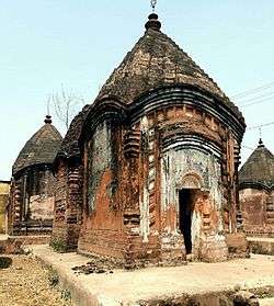 Maluti Temple
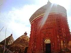 Malooti mandir
 Malooti mandir
 Malooti mandir
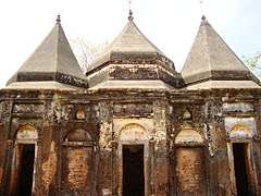 Malooti mandir
 Malooti mandir
 Malooti mandir
Masanjore Dam
| Wikivoyage has a travel guide for Massanjore. |

Masanjore is a famous picnic spot situated 30 km to the Dumka town in Dumka District of Jharkhand. This small village is about 30 km south of Dumka. The picturesque Masanjore dam on the Mayurakshi River is a major draw. From the counterpart rupee fund created through supplies of wheat and other materials from Canada for use in India, Canada Govt. devoted those funds to further development of the Mayurakshi project And Masanjore dam was commissioned in 1955. That's why the Dam is still mentioned as Canada Dam. The dam is bounded by hills and forests, a perfect place for outing. Mayurakshi Bhawan Bungalow and Inspection Bungalow, offer excellent and comfortable accommodation in the village. By road, Masanjore is connected with Vakreshwara (59 km), Sainthia (50 km), Tarapith (70 km), Rampurhat (62 km) and Deoghar (98 km).
Kurwa park (Shrishti)
It is a small picnic spot about 5 km to the east of Dumka. It has a beautiful park, facilities for boating and a small hill.
Chutonath
It is situated 20 km from the district headquarters. It is a beautiful place and picnic spot having natural beauty surrounded by hillocks and river.Chutonath is a religious place of Hindu god Lord chutonath. This festival is celebrated mainly in the month of April. This area has become an attractive tourist place.
Dharmasthan
It is temple situated in Tin bazaar at the heart of Dumka Town, it is very famous for Goddess Kali, during the Durga puja 7 days special puja is organised here.
There are four malls in Dumka 1. V-Mart 2. M-Bazar 3. 1-India Family Mart 4. Bazaar India
Transport
Rail
| Jasidih–Dumka–Rampurhat line | ||||||||||||||||||||||||||||||||||||||||||||||||||||||||||||||||||||||||||||||||||||||||||||||||||||||||||||||||||||||||||||||||||||||||||||||||||||||||||||||||||||||||||||||||||||||||||||||||||||||||||||||||||||||||||||||||||||||||||||||||||||||||||||||||||||||||||||||||||||||||||||||||||||||||||||||||||||||||||||||||||||||||||||||||||||||||||||||||||||||||||||||||||||||||||||||||||||||||||||||||
|---|---|---|---|---|---|---|---|---|---|---|---|---|---|---|---|---|---|---|---|---|---|---|---|---|---|---|---|---|---|---|---|---|---|---|---|---|---|---|---|---|---|---|---|---|---|---|---|---|---|---|---|---|---|---|---|---|---|---|---|---|---|---|---|---|---|---|---|---|---|---|---|---|---|---|---|---|---|---|---|---|---|---|---|---|---|---|---|---|---|---|---|---|---|---|---|---|---|---|---|---|---|---|---|---|---|---|---|---|---|---|---|---|---|---|---|---|---|---|---|---|---|---|---|---|---|---|---|---|---|---|---|---|---|---|---|---|---|---|---|---|---|---|---|---|---|---|---|---|---|---|---|---|---|---|---|---|---|---|---|---|---|---|---|---|---|---|---|---|---|---|---|---|---|---|---|---|---|---|---|---|---|---|---|---|---|---|---|---|---|---|---|---|---|---|---|---|---|---|---|---|---|---|---|---|---|---|---|---|---|---|---|---|---|---|---|---|---|---|---|---|---|---|---|---|---|---|---|---|---|---|---|---|---|---|---|---|---|---|---|---|---|---|---|---|---|---|---|---|---|---|---|---|---|---|---|---|---|---|---|---|---|---|---|---|---|---|---|---|---|---|---|---|---|---|---|---|---|---|---|---|---|---|---|---|---|---|---|---|---|---|---|---|---|---|---|---|---|---|---|---|---|---|---|---|---|---|---|---|---|---|---|---|---|---|---|---|---|---|---|---|---|---|---|---|---|---|---|---|---|---|---|---|---|---|---|---|---|---|---|---|---|---|---|---|---|---|---|---|---|---|---|---|---|---|---|---|---|---|---|---|---|---|---|---|---|---|---|---|---|---|---|---|---|---|---|---|---|---|---|---|---|---|---|---|---|---|---|---|---|---|---|---|---|---|---|---|---|---|---|---|
| ||||||||||||||||||||||||||||||||||||||||||||||||||||||||||||||||||||||||||||||||||||||||||||||||||||||||||||||||||||||||||||||||||||||||||||||||||||||||||||||||||||||||||||||||||||||||||||||||||||||||||||||||||||||||||||||||||||||||||||||||||||||||||||||||||||||||||||||||||||||||||||||||||||||||||||||||||||||||||||||||||||||||||||||||||||||||||||||||||||||||||||||||||||||||||||||||||||||||||||||||
| ||||||||||||||||||||||||||||||||||||||||||||||||||||||||||||||||||||||||||||||||||||||||||||||||||||||||||||||||||||||||||||||||||||||||||||||||||||||||||||||||||||||||||||||||||||||||||||||||||||||||||||||||||||||||||||||||||||||||||||||||||||||||||||||||||||||||||||||||||||||||||||||||||||||||||||||||||||||||||||||||||||||||||||||||||||||||||||||||||||||||||||||||||||||||||||||||||||||||||||||||
However, in July 2011, Dumka was connected to Jasidih with the newly built Jasidih - Dumka railway line. Since then, the city has seen a growing number of three-wheelers on the road. in June 2015, Dumka Rampurhat Train service is also started. There is also ongoing work on a new railway line, which will connect Dumka to Bhagalpur (Bihar in coming years. 18619/Ranchi - Dumka Intercity Express terminates here.
Road
Dumka is connected by road to the neighboring cities such as Deoghar, Bhagalpur, Dhanbad, Rampurhat. Buses are the preferred mode of transport and are run by both government agencies and private operators. Dumka has good connectivity to neighboring districts with buses. There is a luxury night bus service between Dumka - Ranchi and Kolkata. The road network of Dumka is very well maintained.
See also
References
- ↑ "Dumka Population Census 2011". Census Commission of India. Retrieved 2017-07-20.
- ↑ Falling Rain Genomics, Inc - Dumka
- ↑ "Dumka Climate Normals 1971-1990". National Oceanic and Atmospheric Administration. Retrieved 22 December 2012.
Further reading
- Verma, K. K., Alvi, N. M., Lal, B. B., & India. (1981). Special survey reports on selected towns: Series 4. Delhi: Controller of Publications.