Grand Trunk Road
| Grand Trunk Road | |
|---|---|
| GT Road | |
| Route information | |
| Length | 2,700 km[1] (1,700 mi) |
| Status | Currently functional |
| Existed | before 322 BCE – present |
| History | Maurya Empire |
| Time period | c. 322 and 187 BCE |
| Cultural significance | South Asian history |
| Known for | Maurya Empire, Kos Minar, Dhaba, Sher Shah Suri |
| Major junctions | |
| East end | Chittagong, Bangladesh |
| West end | Kabul, Afghanistan |
| Location | |
| Major cities | Chittagong, Dhaka, Rajshahi, Purnea, Patna, Varanasi, Allahabad, Kanpur,Aligarh,Agra, Mathura, Delhi, Sonipat, Panipat, Kurukshetra, Ambala, Ludhiana, Amritsar, Lahore, Gujranwala, Rawalpindi, Peshawar, Jalalabad, Kabul |
.jpg)
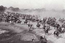
The Grand Trunk Road is one of Asia's oldest and longest major roads.[2] For more than two millennia, it has linked South Asia with Central Asia. It runs from Chittagong, Bangladesh[3][4] west to Howrah, West Bengal in India, then across Northern India through Delhi, passing from Amritsar. From there, the road continues towards Lahore and Peshawar in Pakistan, finally terminating in Kabul, Afghanistan.[5]
The route spanning the Grand Trunk (GT) road existed during the reign of Chandragupta Maurya, extending from the mouth of the Ganges to the north-western frontier of the Empire.[6] The predecessor of the modern road was rebuilt by Sher Shah Suri, who renovated and extended the ancient Mauryan route in the 16th century.[7] The road was considerably upgraded in the British period between 1833 and 1860.[8]
It coincides with current N1 (Chittagong to Dhaka), N4 & N405 (Dhaka to Sirajganj), N507 (Sirajganj to Natore) and N6 (Natore to Rajshai towards Purnea in India) in Bangladesh; NH 12 (Rajshahi to Purnea), NH 27 (Purnea to Patna), NH 19 (Patna to Agra), NH 44 (Agra to Jalandhar via New Delhi, Sonipat, Ambala and Ludhiana) and NH 3 (Jalandhar to Attari, Amritsar towards Lahore in Pakistan) in India; N-5 (Lahore, Gujranwala, Gujrat, Jhelum, Rawalpindi, Peshawar and Khyber Pass towards Jalalabad in Afghanistan) in Pakistan and AH1 (Torkham-Jalalabad to Kabul) in Afghanistan.
History
Research indicates that the Grand Trunk road predated even Buddha's birth and was called Uttara Path, meaning, road to the North. Salman Rashid attributes the Road's construction to Chandragupta Maurya.[9] During the time of the Maurya Empire in the 3rd century BCE, overland trade between India and several parts of Western Asia and the Hellenistic world went through the cities of the north-west, primarily Takshashila (in present-day in Pakistan). Takshashila was well connected by roads with other parts of the Maurya empire. The Mauryas had maintained this very ancient highway from Takshashila to Pataliputra (present-day Patna in India). Chandragupta Maurya had a whole army of officials overseeing the maintenance of this road as told by the Greek diplomat Megasthenes who spent fifteen years at the Mauryan court. Constructed in eight stages, this road is said to have connected the cities of Purushapura, Takshashila, Hastinapura, Kanyakubja, Prayag, Pataliputra and Tamralipta, a distance of around 2,600 kilometres (1,600 mi).[6]
.jpg)
Sher Shah however remains the only mentioned person as the builder of what is now the complete stretch of GT Road, which was referred to as Shah Rah e Azam (Urdu: شاہراہ اعظم or The Great Road). During his reign, Caravanserais were built and trees were planted along the entire stretch on both sides of the road to provide shade to travelers. Wells were also dug, especially along the Taxila section. The Mughuls later extended the road further east to Chittagong and west to Kabul and referred to the road as Sarak e Azam (Urdu: سڑک اعظم, also meaning The Great Road).[10]
In the 1830's the East India Company started a programme of metalled road construction, for both commercial and administrative purposes. The Grand trunk road, from Calcutta, through Delhi, to Peshawar (present-day Pakistan) was rebuilt at a cost of £1000 / mile, and a Public Works Department, and the Indian Institute of Technology Roorkee founded, to train and employ local surveyors, engineers, and overseers, to perform the work, and in future maintain it and other roads[11][12].
Over the centuries, the road acted as one of the major trade routes in the region and facilitated both travel and postal communication. The Grand Trunk Road is still used for transportation in present-day India, where parts of the road have been widened and included in the national highway system, retaining the old name.[13]
GT Road is mentioned in a number of literary works including those of Foster and Rudyard Kipling. Kipling described the road as: "Look! Look again! and chumars, bankers and tinkers, barbers and bunnias, pilgrims – and potters – all the world going and coming. It is to me as a river from which I am withdrawn like a log after a flood. And truly the Grand Trunk Road is a wonderful spectacle. It runs straight, bearing without crowding India's traffic for fifteen hundred miles – such a river of life as nowhere else exists in the world."[14]
Gallery
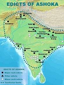 Distribution of the Edicts and Pillars of Ashoka along the GT road
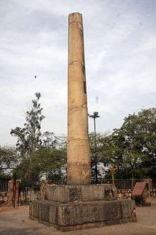 Ashokan pillar currently at Feroz Shah Kotla in Delhi was moved from Topra Kalan in Yamunanagar district
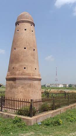 Mughal era Kos Minar along GT road at Taraori in Karnal district
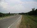
.jpg) Jalalabad–Kabul Road, Afghanistan, is western-most, and most dangerous, stretch of the GT Road
Jalalabad–Kabul Road, Afghanistan, is western-most, and most dangerous, stretch of the GT Road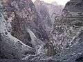 Mountain pass on the Kabul Jalalabad Highway
 GT Road above the River Jhelum in Pakistan.
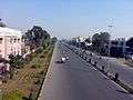 G.T. Road in Lahore
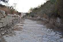 Original GT Road passing through Margalla Hills to Kala Chitta Range
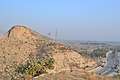 Newly realigned G T Road passing by the westernmost point of Margalla Hills near Islamabad to Kala Chitta Range
See also
Ancient roads
- Silk route – ancient Sino-India-Europe route
- Via Maris (International Trunk Road) – modern name of main ancient international route between Egypt and Mesopotamia
Modern roads in Asia
- AH1, or Asian Highway 1 – the longest route of the Asian Highway Network, running from Japan to Turkey
- Asian Highway Network (AH) aka the Great Asian Highway - project to improve the highway systems in Asia
- Afghanistan
- Highway 1 (Afghanistan) – 2,200 km (1,400 mi) circular road network inside Afghanistan
- Pakistan
- National Highways of Pakistan, all government highways
- Motorways of Pakistan – network of major expressways
- India
- National Highways Authority of India
- National Highway (India) – network of government-managed highways
- Indian Expressways – the highest class of roads in the Indian road network
- Golden Quadrilateral – highway network connecting major centres of northern, western, southern and eastern India
- National Highways Development Project – a project to upgrade and widen major highways in India
Literature
- Farooque, Abdul Khair Muhammad (1977), Roads and Communications in Mughal India. Delhi: Idarah-i Adabiyat-i Delli.
- Weller, Anthony (1997), Days and Nights on the Grand Trunk Road: Calcutta to Khyber. Marlowe & Company.
- Kipling, Rudyard (1901), Kim. Considered one of Kipling's finest works, it is set mostly along the Grand Trunk Road. Free e-texts are available, for instance here.
References
- ↑ Bergsma, Harold (2011). India: Essays and Insights by a Gora. Lulu. p. 137. ISBN 978-8183320610. Retrieved 19 July 2016.
- ↑ Bhandari, Shirin (2016-01-05). "Dinner on the Grand Trunk Road". Roads & Kingdoms. Retrieved 2016-07-19.
- ↑ Steel, Tim (1 January 2015). "A road to empires". Dhaka Tribune. Retrieved 2016-07-19.
- ↑ Jhimli Mukherjee Pandey (15 September 2015). "Cuisine along G T Road". Calcutta: Times of India. Retrieved 2016-07-19.
- ↑ Khanna, Parag. "How to Redraw the World Map". The New York Times. ISSN 0362-4331. Retrieved 2016-07-19.
- 1 2 K. M. Sarkar (1927). The Grand Trunk Road in the Punjab: 1849-1886. Atlantic Publishers & Distri. pp. 2–. GGKEY:GQWKH1K79D6.
- ↑ Chaudhry, Amrita (27 May 2012). "Cracks on a historical highway". The Indian Express. Archived from the original on 22 May 2013. quote: What Chandragupta had begun, his grandson Ashoka perfected. Trees were planted, ... Serais built. p. 2
- ↑ David Arnold (historian); Science, technology, and medicine in colonial India (New Cambr hist India v.III.5) Cambridge University Press, 2000, 234 pages p. 106
- ↑ Salopek, Paul (April 4, 2018). "On Foot in Pakistan, Dodging a World on the Move". National Geographic Society.
Who built the Grand Trunk Road? The Pakistani writer Salman Rashid awards this laurel to Chandragupta, the remarkable founder of the Mauryan Empire. (321 to 185 B.C.)
- ↑ Bhattacharya, Avijeet (2017-10-11). Journeys on the Silk Road Through Ages—Romance, Legend, Reality. ISBN 9789386407818.
- ↑ St. John, Ian (2011). The Making of the Raj: India under the East India Company. ABC-CLIO. pp. 83–84. ISBN 9780313097362. Retrieved 15 May 2018.
- ↑ Gupta, Das (2011). Science and Modern India: An Institutional History, c.1784-1947: Project of History of Science, Philosophy and Culture in Indian Civilization, Volume XV, Part 4. Pearson Education India. pp. 454–456. ISBN 9788131753750.
- ↑ Singh, Raghubir (1995). The Grand Trunk Road: A Passage Through India (First ed.). Aperture Books.
- ↑ A description of the road by Kipling, found both in his letters and in the novel Kim.
Further reading
- Usha Masson Luther; Moonis Raza (1990). Historical routes of north west Indian Subcontinent, Lahore to Delhi, 1550s–1850s A.D. Sagar Publications.
- Arden, Harvey (May 1990). "Along the Grand Trunk Road". National Geographic. 177 (5): 118–38.
- Mozammel, Md Muktadir Arif (2012). "Grand Trunk Road". In Islam, Sirajul; Jamal, Ahmed A. Banglapedia: National Encyclopedia of Bangladesh (Second ed.). Asiatic Society of Bangladesh.
- Tayler, Jeffrey (November 1999). "India's Grand Trunk Road". The Atlantic Monthly. 284 (5): 42–48.
External links
| Wikivoyage has a travel guide for Grand Trunk Road. |
- National Highway Authority of India
- National Highway Authority of Pakistan
- NPR: Along the Grand Trunk Road
| Wikimedia Commons has media related to Grand Trunk Road. |