Gopalganj district, India
| Gopalganj district | |
|---|---|
| District of Bihar | |
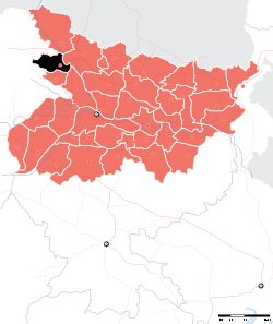 Location of Gopalganj district in Bihar | |
| Country | India |
| State | Bihar |
| Administrative division | Saran |
| Headquarters | [[Gopalganj]] |
| Government | |
| • Lok Sabha constituencies | Gopalganj |
| • Assembly seats | Baikunthpur, Barauli, Gopalganj, Kuchaikote, Bhore, Hathua |
| Population (2011) | |
| • Total | 2,558,037 |
| Demographics | |
| • Literacy | 67.04 per cent |
| • Sex ratio | 1021 |
| Major highways | NH-28 |
| Website | Official website |
Gopalganj is one of the administrative districts in the Indian state of Bihar. The district headquarters is the town of Gopalganj, and the district is part of Saran Division.[1] Major languages spoken are Bhojpuri, and Hindi.
Geography
Gopalganj district, India occupies an area of 2,033 square kilometres (785 sq mi),[2] comparatively equivalent to Spain's Tenerife Island.[3]
Economy
In 2006 the Ministry of Panchayati Raj named Gopalganj one of the country's 250 most backward districts (out of a total of 640).[4] It is one of the 38 districts in Bihar currently receiving funds from the Backward Regions Grant Fund Programme (BRGF).[4]
Demographics
According to the 2011 census Gopalganj district, India has a population of 2,558,037,[5] roughly equal to the nation of Kuwait[6] or the US state of Nevada.[7] This gives it a ranking of 163rd in India (out of a total of 640).[5] The district has a population density of 1,258 inhabitants per square kilometre (3,260/sq mi) .[5] Its population growth rate over the decade 2001-2011 was 18.83%.[5] Gopalganj has a sex ratio of 1015 females for every 1000 males,[5] and a literacy rate of 67.04%.[5]
Based on the 2010 census:
- Population: 2,558,037 (2.62% of the state)[8]
- Density of population: 1258
- Men: 1,269,677 (49.89%)
- Women: 1,288,360 (50.12%)
- Urban population: 130,536 (6.07%)
- Rural population: 2,018,807 (93.93%)
- % of Scheduled castes: 12.43%
- % of Scheduled tribes: 0.29%
Education
Initially, Gopalganj had little to offer in terms of good quality education to its residents. Presently Schools and colleges in the city are either run by the government or by private trusts and individuals. The schools are each affiliated with either the Central Board for Secondary Education (CBSE), or the Bihar School Examination Board.[9] English is the medium of instruction in most private schools; though government run schools offer both English and Hindi. The Sainik School prepares boys for entry into the National Defence Academy. After completing their secondary education, which involves ten years of schooling, students typically enroll at Higher Secondary School in one of the three streams—Arts, Commerce or Science.
Administrative Division
Gopalganj is divided into 2 sub-divisions, 14 Blocks, 4 municipalities and 234 gram-panchayat (village councils). There are total 1566 villages in Gopalganj District.[10]
| Subdivision | CD Block | Hindi name | Area (KM2) | Population (2011) |
|---|---|---|---|---|
| 2 | 14 | १४ | 2,033 | 2,562,012 |
| Gopalganj | Baikunthpur | बैकुंठपुर | 204.11 | 217,165 |
| Gopalganj | Barauli | बरौली | 184.38 | 263,876 |
| Gopalganj | Gopalganj | गोपालगंज | 195.47 | 219,527 |
| Gopalganj | Kuchaikote | कुचायकोट | 251.43 | 332,041 |
| Gopalganj | Manjha | मांझा | 141.47 | 199,452 |
| Gopalganj | Thawe | थावे | 69.99 | 116,106 |
| Gopalganj | Sidhwaliya | सिधवलिया | 120.13 | 141,563 |
| Hathua | Bhorey | भोरे | 147.73 | 178,199 |
| Hathua | Hathua | हथुआ | 146.65 | 221,804 |
| Hathua | Kateya | कटेया | 126.17 | 130,830 |
| Hathua | Panchdewari | पंचदेवरी | 92.82 | 99,933 |
| Hathua | Phulwariya | फुलवरिया | 95.56 | 130,801 |
| Hathua | Uchkagaon | ऊँचकागांव | 113.29 | 177,677 |
| Hathua | Vijayipur | विजयीपुर | 130.40 | 133,038 |
Urban councils
There are 4 urban area in Gopalganj district. 3 Nagar Panchayat and 1 Nagar Parishad. Although Hathua is also an urban area categorized as Census town but not counted as municipality.
| City council | Council's type | Hindi name | part of (Block) | Area (KM²) | Population (2011) |
|---|---|---|---|---|---|
| Gopalganj | Nagar Parishad | गोपालगंज | Gopalganj | 11.11 | 67,339 |
| Kataiya | Nagar Panchayat | कटैया | Kataiya | 12.06 | 20,193 |
| Mirganj | Nagar Panchayat | मीरगंज | Unchkagaon | 5.48 | 26,240 |
| Barauli | Nagar Panchayat | बरौली | Barauli | 22.21 | 41877 |
| Hathua | Census town | हथुआ | Hathua | 1.06 | 7,156 |
Village councils
There are 234 Village councils in Gopalganj district grouped into 14 blocks.
Vidhan Sabha Constituency
- Baikunthpur
- Barauli
- Gopalganj
- Kuchaikote
- Bhore
- Hathua
Transport
- Road
NH 28 passes through Gopalganj one can find the multiple buses for commuting in state and other state
- Rail
Siwan Junction railway station is the main railway station for Gopalganj ,Thawe station also serves local passenger, other Small Railway Stations are
- Hathua Bazaar
- Sasamusa
- Sipaya(Near kuchaikote and Khutwania)
- Tamkuhi Road
- Air
Jay Prakash Narayan Airport Patna and Mahayogi Gorakhnath Airport Gorakhpur is the nearest commercial airport
People from the Gopalganj district
- Abdul Ghafoor, former Chief Minister of Bihar, 1973 to 1975
- Laloo Prasad Yadav, former Chief Minister of Bihar and former Rail Minister of India
- Rabri Devi, thrice Chief Minister of Bihar, wife of Laloo Prasad Yadav
- Ram Dulari Sinha of the Indian National Congress, former Union-Minister of state, and Former Governor of Kerala, and freedom fighter
- UK Sinha, Chairman of the Securities and Exchange Board of India
- Anurag Kumar, Director, IISc.
- Pankaj Tripathi, Actor, Bollywood.
- Avinash Tiwari, Actor, Bollywood. Upcoming movie "LAILA MAJNU" by Imtiaz Ali, 24 Aug18.
- Deepak Ram, HR-Officer, KSA
- Priyanka Singh, Singer, Bollywood, Runner of "Sur-Sangram" Mahua
See also
References
- ↑ "Welcome GOPALGANJ". Gopalganj.bih.nic.in. 2011-07-21. Archived from the original on 2011-07-21.
- ↑ Srivastava, Dayawanti et al. (ed.) (2010). "States and Union Territories: Bihar: Government". India 2010: A Reference Annual (54th ed.). New Delhi, India: Additional Director General, Publications Division, Ministry of Information and Broadcasting (India), Government of India. pp. 1118–1119. ISBN 978-81-230-1617-7.
- ↑ "Island Directory Tables: Islands by Land Area". United Nations Environment Program. 1998-02-18. Retrieved 2011-10-11.
Tenerife2,034km2
- 1 2 Ministry of Panchayati Raj (September 8, 2009). "A Note on the Backward Regions Grant Fund Programme" (PDF). National Institute of Rural Development. Archived from the original (PDF) on April 5, 2012. Retrieved September 27, 2011.
- 1 2 3 4 5 6 "District Census 2011". Census2011.co.in. 2011. Retrieved 2011-09-30.
- ↑ US Directorate of Intelligence. "Country Comparison:Population". Retrieved 2011-10-01.
Kuwait 2,595,62
- ↑ "2010 Resident Population Data". U. S. Census Bureau. Archived from the original on 2011-07-21. Retrieved 2011-09-30.
Nevada 2,700,551
- ↑ "Gopalganj District At a Glance". Gopalganj.bih.nic.in. 2011-07-21. Archived from the original on 2011-07-21. Retrieved 2012-08-24.
- ↑ "Bihar School Examination Board". Biharboard.bih.nic.in. 2010-12-03. Retrieved 2012-08-24.
- ↑ "archive".
Places adjacent to Gopalganj district, India | |
|---|---|
| State symbols | |
|---|---|
| History |
|
| Administration | |
| Overviews | |
| Divisions and districts | |
| Cities | |
| Municipal Corporation |
|
| Poltics | |
| Culture | |