Singhbhum district
| Singhbhum District | |||||
| District of the Bengal Presidency | |||||
| |||||
 | |||||
 | |||||
| Capital | Chaibasa | ||||
| History | |||||
| • | The Raja of Singhbhum becomes a feudatory of the British | 1820 | |||
| • | Post-independence Singhbhum District | 1947 | |||
| Area | |||||
| • | 1901 | 10,078 km2 (3,891 sq mi) | |||
| Population | |||||
| • | 1901 | 613,579 | |||
| Density | 60.9 /km2 (157.7 /sq mi) | ||||
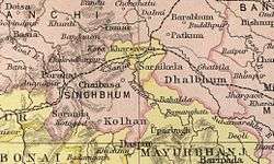
Singhbhum was a district of India during the British Raj, part of the Chota Nagpur Division of the Bengal Presidency.[1] It was located in the present-day Indian state of Jharkhand. Chaibasa was the district headquarters. Located in the southern limit of the Chhota Nagpur Plateau, Singhbhum included the Kolhan estate located in its southeastern part.[2] The district has been divided into three smaller districts, being East Singhbhum, West Singhbhum and Saraikela Kharsawan all are present in Jharkhand state of India.
Geography
It bounded with Ranchi District in the north, with the Saraikela and Kharsawan princely states in the east, with Mayurbhanj and Keonjhar in the south as well as with Bonai and Gangpur in the southwest.[2] Singhbhum District had an area of 10,078 square kilometres (3,891 sq mi) and a population of 613,579 in 1901.[3]
History
The Singhbhum area was never invaded by either the Marathas or the Mughals. The first relationships between the Raja of Singhbhum and the British were established in 1767 when he approached the Resident at Midnapore requesting protection. In 1820 the Raja became a feudatory of the British. The state was under the political control of the Commissioner of the Bengal Presidency until 1912,[2] under the Bihar and Orissa Province until 1936 and then under Chhota Nagpur Division until the end of the British Raj.
Following the independence of India Singhbhum District became part of the Indian Union as a district of Bihar. The district has in recent decades been divided into three smaller districts, being East Singhbhum, West Singhbhum and Saraikela Kharsawan. All the three are currently part of Jharkhand state of India. The major Indian languages spoken in this region are Bengali, Odia, Kurmali and many tribal languages.
Etymology
The literal meaning of Singhbhum or Singhbhumi is Land of lions: Singh in Odia Language means lion and Bhum or Bhumi indicates land. This appears to be apt as more than 50% area of the district is covered by dense forests and mountains, where wild animals once roamed freely. However, the lion is not found in these forests any more.
Singhbhum is known for its iron ore deposits and it provides for the iron ore requirements of the IISCO steel plants located at Hirapur, Kulti and Burnpur.
References
- ↑

- 1 2 3 Imperial Gazetteer of India, v. 23, p. 1.
- ↑ Wilson Hunter, Sir William; Sutherland Cotton, James; Sir Richard Burn, Sir William Stevenson Meyer. Great Britain India Office. The Imperial Gazetteer of India. Oxford: Clarendon Press, 1908