Varanasi district
| Varanasi district | |
|---|---|
| District of Uttar Pradesh | |
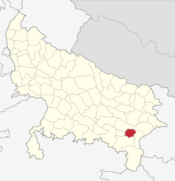 Location of Varanasi district in Uttar Pradesh | |
| Country | India |
| State | Uttar Pradesh |
| Administrative division | Varanasi |
| Headquarters | Varanasi |
| Government | |
| • Lok Sabha constituencies | Varanasi |
| Area | |
| • Total | 1,535 km2 (593 sq mi) |
| Population (2011) | |
| • Total | 3,676,841[1] |
| Website | Official website |
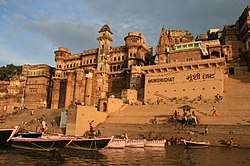
Varanasi district is a district in the north Indian state of Uttar Pradesh with Varanasi city as the district headquarters.It is also called as kashi, according to Hindu mythology it is believed that Lord Shiva along with Parvathy as Vishwanatha and Vishalaakshi resides there to bless devotees. Ganga river flows through the district which is considered as sacred and pure river, which has the capacity to wash away all the sins made by the humans if they bath in the river. Part of Varanasi division, the district occupies an area of 1,535 square kilometres (593 sq mi) and as of the 2011 Census of India had a population of 3,682,194.
Divisions
The district is made up of three tehsils: Varanasi, Pindra, and Rajatalab[2], and eight Vidhan Sabha (Legislative Assembly) constituencies: Pindra, Ajagara, Shivpur, Rohaniya, Varanasi North, Varanasi South, Varanasi Cantt. and Sevapuri.
Demographics
According to the 2011 census Varanasi district has a population of 3,682,194,[1] roughly equal to the nation of Liberia[3] or the US state of Oklahoma.[4] This gives it a ranking of 75th in India (out of a total of 640).[1] The district has a population density of 2,399 inhabitants per square kilometre (6,210/sq mi) .[1] Its population growth rate over the decade 2001-2011 was 17.32%.[1] Varanasi has a sex ratio of 909 females for every 1000 males,[1] and a literacy rate of 77.05%.[1]
Languages
- Bhojpuri and Hindi are spoken in Varanasi and written in Devanagari scripts.
- Urdu is written in the Nastaliq style of the Persian alphabet.
Colleges
- DAV Post Graduate College Varanasi [5]
- Law School Banaras Hindu University
- Shri Harishchandra pg college
Geography
Places adjacent to Varanasi district | |
|---|---|
References
- 1 2 3 4 5 6 7 "Official Census". Retrieved 2014-03-10.
- ↑ "Rajatalab tehsil inaugurated". The Times of India. The Times of India. Retrieved 23 July 2017.
- ↑ US Directorate of Intelligence. "Country Comparison:Population". Retrieved 2011-10-01.
Liberia 3,786,764 July 2011 est.
- ↑ "2010 Resident Population Data". U. S. Census Bureau. Retrieved 2011-09-30.
Oklahoma 3,751,351
- ↑ http://www.davpgcvns.ac.in/
External links
Coordinates: 25°20′N 83°00′E / 25.333°N 83.000°E