North East Delhi
| North East Delhi | |
|---|---|
| District | |
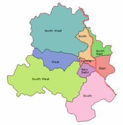 Location of North East Delhi district in Delhi | |
| Country |
|
| State | Delhi |
| Headquarters | Seelampur |
| Government | |
| • Type | Administrative Division |
| • Lok Sabha constituencies | North East Delhi |
| • Vidhan Sabha constituencies | Karawal Nagar, Mustafabad, Seelampur, Gokalpur etc |
| Area | |
| • District | 62 km2 (24 sq mi) |
| Population (2011)[1] | |
| • District | 2,241,624 |
| • Density | 36,155/km2 (93,640/sq mi) |
| • Urban | 2,220,097 |
| • Rural | 21,527 |
| Demographics | |
| • Population Growth | 26.78% |
| • Literacy | 83.09% |
| • Sex Ratio | 886 |
| Languages | |
| • Official | Hindi, English |
| Time zone | UTC+5:30 (IST) |
| Website | Official Website |
North East Delhi is one of the eleven administrative districts of Delhi, India. The District was established in 1997. North East Delhi borders Yamuna River on the west, Ghaziabad District to the north and east, East Delhi to the south, and North Delhi to the west across the Yamuna. This area is densely populated with very slow development as compared to other districts. No development took place here even during commonwealth games makeover of other districts of Delhi. For public transport people are totally dependent upon overloaded sharing Autos. Half of the roads are covered by street hawkers. Exits connecting this place with other districts (Shastri Park and Wazirabad) with other parts are fully choked in peak hours.
Demographics
According to the 2011 census, North East Delhi had a population of 2,241,624, roughly equal to the nation of Latvia, or the United States state of New Mexico.[2][3] This gives it a ranking of 202nd in India (out of a total of 640).[2] The district has a population density of 36,155 inhabitants per square kilometre (93,640/sq mi) .[2] Its population growth rate over the decade 2001-2011 was 26.78%.[2] North East Delhi has a sex ratio of 886 females for every 1000 males,[2] and a literacy rate of 83.09%.[2]
Towns and villages
North East Delhi incorporates the following towns:[4]
- Yamuna Vihar
- Moujpur
- Babar Pur
- Dayal Pur
- Gokal Pur
- Sonia Vihar
- Mandoli
- Saboli
- Nand Nagri
- Sunder Nagri
- Seemapuri
- Dilshad Garden
- Jaffrabad
- Jiwan Pur (Johri Pur)
- Karawal Nagar
- Khajoori Khas
- Mir Pur Turk
- Mustafabad
- Sadat Pur Gujran
- New Usmanpur
- Ziauddin Pur
- Harsh Vihar
Villages in North East Delhi are divided into three administrative villages: Shahdara with no sub-villages, Seema Purl with one sub village, Mandoli, and Seelam Pur with twelve sub-villages:[5]
- Badar Pur Khadar
- Pur Delhi
- Pur Shahdara
- Saba Pur Delhi
- Saba Pur Shahdara
- Baqiabad
- Sadat Pur Musalmanan
- Bihari Pur
- SherPur Gujran
- Garhi Mendu
- Tukhmir Pur
- Khan Pur Dhani
See also
References
- ↑ "North East Delhi District : Census 2011 data". Census Organisation of India. 2011. Retrieved 31 December 2013.
- 1 2 3 4 5 6 "District Census 2011". Census2011.co.in. 2011. Retrieved 30 September 2011.
- ↑ US Directorate of Intelligence. "Country Comparison:Population". Retrieved 1 October 2011.
Latvia 2,204,708 July 2011 est.
- ↑ "2001 Census of India: List of Towns by District: Delhi" (PDF). Registrar General & Census Commissioner, India. p. 1.
- ↑ "2001 Census of India: List of Villages by District and Tehsil: Delhi" (PDF). Registrar General & Census Commissioner, India. pp. 2&ndash, 3.
External links
Places adjacent to North East Delhi | ||||||||||
|---|---|---|---|---|---|---|---|---|---|---|
| ||||||||||
Coordinates: 28°41′37″N 77°18′26″E / 28.6936°N 77.3073°E