Hazaribagh
| Hazaribagh | |
|---|---|
| City | |
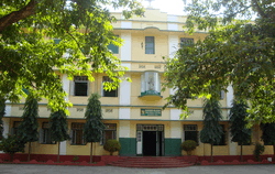 St. Xaviers Hazaribagh | |
 Hazaribagh Location in Jharkhand, India  Hazaribagh Hazaribagh (India) | |
| Coordinates: 23°59′N 85°21′E / 23.98°N 85.35°ECoordinates: 23°59′N 85°21′E / 23.98°N 85.35°E | |
| Country |
|
| State | Jharkhand |
| District | Hazaribagh |
| Elevation | 610 m (2,000 ft) |
| Population (2011) | |
| • Total | 186,139 |
| Languages | |
| • Official | Hindi, Urdu |
| Time zone | UTC+5:30 (IST) |
| PIN | 825301 |
| Vehicle registration | JH-02 |
| Website |
hazaribag |
Hazaribagh (also spelled Hazaribag) is a city and a municipality in Hazaribagh district in the Indian state of Jharkhand. It is the divisional headquarters of North Chotanagpur division. It is famous as a health resort and for Hazaribag Wildlife Sanctuary (17 km from city). It is represented in the Indian Lok Sabha by its Member of Parliament Jayant Sinha.[1]
Etymology
The word 'Hazaribagh' is made of two Persian words: Hazar meaning 'one thousand' and bagh meaning 'garden'. Hence the meaning of Hazaribagh is 'city of a thousand gardens'. According to Sir John Houlton, however, the town takes its name from the small villages of Okni and Hazari – shown on old maps as Ocunhazry. The last syllable in its name probably originated from a mango grove which formed a camping ground for troops and travelers marching along a military road from Kolkata to Varanasi, constructed in 1782 and the following years. The Grand Trunk Road subsequently replaced this military road in the mid-9th century, but the layout differed at places, particularly around Hazaribagh. A dilapidated watch tower meant to guard the military road is still visible on Tower Hill, near Silwar.[2]
Geography
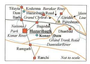
Konar River, a tributary of Damodar River, flows past the town. Hazaribagh has been a thick forest earlier and is still surrounded by forests.
Travelling times
- Air
The nearest airport is Birsa Munda Airport Ranchi, the capital of Jharkhand, (91 km). Ranchi is connected with New Delhi, Mumbai, Kolkata, Patna and Lucknow by regular service of many airlines.
- Rail
A new 80 km long railway line has been constructed from Koderma to Hazaribagh and became operational in February 2015. Two trains run between Koderma and Hazaribagh Town railway station (not to be confused with Hazaribagh Road railway station). The railway line from Hazaribagh to Barkakana Junction has been completed and the trains are running from Hazaribagh to Barkakana.
Hazaribagh is situated on NH 33 and the road distances to major cities are: Ranchi 91 km, Dhanbad 128 km (via GT road), Bokaro 116 km (via Ramgarh), Gaya 130 km, Patna 235 km, Daltonganj 198 km, and Kolkata (via Dhanbad-Asansol-Govindapur-Bardhaman) 434 km. Regular bus service connects Hazaribagh to these places.
History
Before independence hazaribhag used to come under the estate of Ramgarh Raj. The last ruler of Ramgarh raj was Raja Bahadur Kamakya Narain Singh along with his brother Maharajakumar Basant Narain Singh.
In ancient times the district was covered with inaccessible forests inhabited by tribes who remained independent. The entire territory of Chhotanagpur, known as Jharkhand (meaning forest territory) was presumably beyond the pale of outside influence in ancient India. Throughout the Turko-Afghan period (up to 1526), the area remained virtually free from external influence. It was only with the accession of Akbar to the throne of Delhi in 1557 that Muslim influence penetrated Jharkhand, then known to the Mughals as Kokrah. In 1585, Akbar sent a force under the command of Shahbaj Khan to reduce the Raja of Chotanagpur to the position of a tributary. After the death of Akbar in 1605, the area presumably regained its independence. This necessitated an expedition in 1616 by Ibrahim Khan Fateh Jang, the Governor of Bihar and brother of Queen Noorjehan. Ibrahim Khan defeated and captured Durjan Sal, the 46th Raja of Chotanagpur. He was imprisoned for 12 years but was later released and reinstated on the throne after he had shown his ability in distinguishing a real diamond from a fake one.
In 1632, Chotanagpur was given as Jagir (endowment) to the Governor at Patna for an annual payment of Rs.136,000. This was raised to Rs.161,000 in 1636. During the reign of Muhammad Shah (1719–1748), Sarballand Khan, the Governor of then Bihar, marched against the Raja of Chotanagpur and obtained his submission. Another expedition was led by Fakhruddoula, the Governor of Bihar in 1731. He came to terms with the Raja of Chotanagpur. In 1735 Alivardi Khan had some difficulty in enforcing the payment of the annual tribute of Rs.12,000 from the Raja of Ramgarh, as agreed to by the latter according to the terms settled with Fakhruddoula.
This situation continued until the occupation of the country by the British. During the Muslim period, the main estates in the district were Ramgarh, Kunda, Chai and Kharagdiha. Subsequent to the Kol uprising in 1831 that, however, did not seriously affect Hazaribagh, the administrative structure of the territory was changed. The parganas of Ramgarh, Kharagdiha, Kendi and Kunda became parts of the South-West Frontier Agency and were formed into a division named Hazaribagh as the administrative headquarters.
In 1854 the designation of South-West Frontier Agency was changed to Chota Nagpur Division, composed of five districts - Hazaribagh, Ranchi, Palamau, Manbhum, and Singhbhum. The division was administered as a Non-regulation province under a Commissioner reporting to the Lieutenant Governor of Bengal.[3] In 1855-56 there was the great uprising of the Santhals against the British but was brutally suppressed.
During British rule, one had to go by train to Giridih and then travel in a vehicle called push-push to Hazaribagh. It was pushed and pulled by human force over hilly tracts. It was an exciting journey across rivers and through dense forests infested with bandits and wild animals. Rabindranath Tagore travelled in a push-push along the route in 1885. He recorded the experience in an essay, "Chotanagpur families". When the Grand Chord railway line was opened in 1906, Hazaribagh Road railway station became the link with the town. For many years, Lal Motor Company operated the rail-cum-bus service between Hazaribagh town and Hazaribagh Road railway station.
In 1912, a new province of Bihar and Orissa was split from Bengal Province. In 1936, the province was split into separate provinces of Bihar and Orissa, with the Chota Nagpur Division being a part of Bihar. Bihar's boundaries remained mostly unchanged after Indian Independence in 1947.
After the 1991 census, the district of Hazaribagh was divided into three separate districts, Hazaribagh, Chatra and Koderma. The two sub-divisions Chatra and Koderma were upgraded to the status of independent districts.
In 2000, Jharkhand was separated from Bihar to become India's 28th state.
Hazaribagh town
The Town became a cantonment in 1790, the Ramgarh battalion having been raised ten years earlier. It was then part of Ramgarh district. It became a district headquarters in 1834. Hazaribagh was constituted as a municipality in 1869. The military cantonment, south-east of the town, flourished until 1874, when, after an outbreak of enteric fever in 1874, the troops were mostly withdrawn, except for a small detachment to mind the penitentiary. This resulted in a planned city. This part of the town is known as Boddam Bazar, after the officer who laid it out. Many Englishmen settled in Hazaribagh during the British period. They built large bungalow-type houses, often with sloping roofs. They were great hunters and hunting stories abounded in the town by word of mouth. Most of them left after India became independent. Tutu Imam topped the list of hunting legends in the town along with Prof. Rajendra Pandey. A century ago it was common for tigers and leopards to prey upon livestock in the outskirts of the town.
The town had a population of 15,799 in the 1901 census. It was described in as "little more than a cluster of hamlets, with intervening cultivation, which sprang up around the former military bazar."
Hazaribagh Central Jail housed many leaders of the Indian freedom movement, including Dr. [Rajendra Prasad], later the first President of India. The popular leader [Jayaprakash Narayan] was put under arrest in this jail during the [Quit India Movement] of 1942. His escape from this high-security prison [with the help of 53 dhotis (sheets) to cross the wall of the jail] and the support he received from the local people is one of the legends of the Indian Independence movement.
During the early years of World War II, an internment camp ("parole camp") for German civilians was established in the town. In June 1942 it housed 36 women, 5 men and 16 children, of whom 21 females with 13 children were transferred on 25 February 1942 from Diyatalawa. In autumn they were transferred to the family camps at Purandhar or Satara.[4]
Early Bengali settlers
A small but effective Bengali community settled at Hazaribagh in the 19th century when the area was in Bengal Presidency and the British administration was looking for people with English education. The small community contributed considerably towards the development of the place.
Rai Bahadur Jadunath Mukhopadhyaya (Mukherjee), one of the early settlers, was the first Government Pleader of Hazaribagh. His house in Hazaribagh Town played host to many eminent persons including Sanjiv Chattopadhaya (of Palamau fame), Rabindranath Tagore and Subhas Chandra Bose. He established the Hazaribagh Brahmo Samaj, donating his own land through a trust he set up. He also helped set up the Durga Puja mandap, the Keshav Hall/Union Club and Library and the first girls' school in the town, donating his own land and admitting his daughter as its first student; the school is now named after him. Chanchala Niyogi made a significant contribution to keep the school going around 1895. Those were the days when people thought that by educating their daughters they were paving the way for their widowhood. Around 1920, the new school building was built with the initiative of Braja Kumar Niyogi with funds mainly from the estate of Raja of Ramgarh. Ray Bahadur Jadunath Mukherjee left behind a large family. Scholars such as Mahesh Chandra Ghosh and Dhirendranath Choudhury made the town their home. The poet Kamini Roy lived in the town for some years. Manmathanath Dasgupta, a Brahmo missionary spent many years in Hazaribagh working amongst the downtrodden. Sarat Kumar Gupta contributed towards the development of the town in many ways. Doctors such as Mandindra Bhushan Banerjee (Panna Babu), Bikash Kumar Sen, Sambhu Nath Roy and Benoy Chandra Chatterjee were prominent personalities. The noted Bengali author and writer for many Hindi films like Sujata, Subodh Ghosh, was born and brought up in Hazaribagh. Many of his stories are set in the region.
Keshub Chunder Sen, the great Brahmo Leader, accompanied by Trailokyanath Sanyal, visited Hazaribagh in 1874 to recoup his health. He wrote many pieces during his short stay and participated in Bhadrotsav celebrations. After his death in 1884, a public hall on the Main Road was named Keshub Hall in his memory. Amongst the Brahmo missionaries who visited Hazaribagh regularly was Pramathalal Sen.
Rai Bahadur Kalipada Sarkar was a leading advocate. He was the chairman of Municipality, chairman of District Board, President of the Bar Association and also a member of the council. He was also the first Indian to be the chairman of Hazaribagh Municipality.
Another notable Bengali of the first half of the 20th century was Rai Bahadur Surendra Nath Roy, the noted government Pleader and a patron of the arts. Suren babu migrated from village Raghunathpur (Nadia,[5] Bengal), where he was a zamindar (জমিদার) and the title 'Rai Bahadur' was conferred on him by the British in 1902 to practice law in the Civil Court at Hazaribagh. For a time he was President of the Bar Association, and was the co-founder of Annada High School (Bengali School). He also acted as the custodian of the minor Kamakhya Narayan Singh, the erstwhile Raja of Ramgarh Raj.
Economy
Industry
Hazaribagh has the second highest coal reserve in Jharkhand (Dhanbad region has the first), and it is still largely intact. Recently there has been a spurt in the coal mining activities in the region by Central Coalfields Ltd., a subsidiary of Coal India Limited. Work is currently going on for the development of NTPC's 3000 MW. Reliance Power's 3600 MW Super Thermal Power Projects was also proposed but was later pulled out due to the failure of the negotiations between government and company on land distributions. Demotand and Chaano are industrial areas.
Education
The Dublin Mission has educational institutions and a women's hospital. Activities of the mission were started at Hazaribagh in 1899, under the aegis of Trinity College, Dublin, Ireland. St. Columba's College was one of the oldest in Bihar. Hazaribagh now has Vinoba Bhave University within the city limits, named after Saint Vinoba Bhave. It is the second largest university of Jharkhand. It also hosts private university AISECT University, Jharkhand. St. Columba's College, Medical College of Dhanbad and many engineering and local colleges are affiliated to this university. Jajnery Institute of Technology, Hazaribagh is a college for Polytechnic, management and IT.
After independence, Roman Catholics established a girls' school, Mount Carmel school Hazaribagh, in 1949. Parallel to this Reverend Father John Moore, an Australian Jesuit missionary, set up St. Xavier's School in 1952. D.A.V Public School Hazaribagh, started in 1992 and run by D.A.V College Managing Committee (New Delhi). National Public School, Hazaribagh, started in 1977, is now affiliated to CBSE, it is managed by L.K.C. Memorial Education Society. Montfort School, Hazaribagh is situated on Kanhari Hill Road. Mount Litera Zee School and Kidzee, Hazaribagh is located at Katgarah Village, opposite the firing range. Meru Hazaribagh and its city office are situated near the Mission Hospital. It is a network of Zee learn.
Hazaribagh has the police training center for the whole of Jharkhand. The Border Security Force (BSF) also has a large presence. East India's largest training center is here in the forest with hilly terrain. The Central Reserved Police Force is also present in the town near the lake.
B.Ed Colleges
- Daulat Mahto M.T.T. College, Banaso, Bishnugarh, Hazaribagh
- Deo College of Education, Hazaribagh
- Gautam Buddha T.T. College, Hazaribagh
- Maa Vindhyavashini College of Education, Hazaribagh
- S.B.M. T.T. College Hazaribagh
- Sri Ram Krishna Sarda Ashram, Teachers Training College, Ravindrapath, Hazaribagh
- Swami Dharmabandhu College of Education Hazaribagh
General Colleges
- Annada College, Hazaribagh
- Bhadrakali College, Itkhori
- G.M. Evening College, Ichak
- Karnpura College, Barkagaon
- K.B. Women's College
- Markham College of Commerce
- Mother Teresa College (MTC)
- St. Columba's College
- Vananchal College, Tandwa
Inter Colleges
- Geeta science inter mahavidyalaya, Hazaribagh
- Gulmohar Inter College Inter science College, Hazaribagh
- Inter Science college
Hazaribagh , Zabra Road
- Chhotanagpur Inter College. Berokala Hazaribag
Schools
- Carmel school Hazaribagh
- Delhi Public School Hazaribagh
- Vivekananda Central School, Rabindra Path
- St. Xavier's, Hazaribagh
- D. A. V. Public School, Canary Hill Road.
- Angels High School
- Naman vidyalaya
Transportation
- ▪ Roadways
Hazaribag is well connected to the other cities around it via a widespread network of highways, most notably the National Highway 33.There is always Ac buses running to major cities.
- > Bus Services
There is a bus station at Hazaribagh where direct buses for major cities like Ranchi, Kolkata, Dhanbad, Patna, Jamshedpur, Giridih Deogarh, Gaya, Nawada, Koderma, Aurangabad etc are available at all times.
- ▪ Railways
The nearest major junction is the Koderma railway station.
A new train station is operative in Hazaribagh since 2014 with DEMU trains connecting it with Barkakana Junction railway station and Koderma Junction railway station.
- ▪ Airways
Birsa Munda Airport in Ranchi is the nearest airport at a distance of 96 km.
Chief Minister Raghubar Das and Minister of State Civil Aviation Jayant Sinha, has proposed for the transformation of Hazaribag Hawai Adda, Nagwan into new domestic airport.
Demographics
As per the 2011 Census of India, Hazaribagh Urban Agglomeration had a total population of 153,599, of which males were 80,095 and females 73,504.[6] Hazaribagh Urban Agglomeration is composed of Hazaribagh (Nagar Parishad) and Okni (Census Town).[7]
As per the 2011 Census of India, Hazaribagh Nagar Parishad had a total population of 142,489, of which 74,132 were males and 68,357 females. Scheduled Castes numbered 7,987 and Scheduled Tribes numbered 2,708.[8]
As of 2001 India census,[9] Hazaribagh had a population of 127,243. Males constitute 53% of the population and females 47%. Hazaribagh has an average literacy rate of 76%, higher than the national average of 59.5%: male literacy is 81%, and female literacy is 70%. In Hazaribagh, 13% of the population is under 6 years of age.
The population of the town and the area is overwhelmingly Khortha speaking, However due to migration of people from other state people Hindi is also spoken but mainly in town areas. There is a sprinkling of the Santhali-speaking population mainly in the rural areas. The Hindus form the majority of Population. There is a sizable Muslim population. Punjabis form small minorities. Hazaribagh Was upgraded to a municipal corporation in June 2015 by adding the area and population of 19 adjoining villages.
Literacy
As per the 2011 census, the total number of literates in Hazaribagh UA was 122,881 (90.14 percent of the total population) out of whom 66,602 (93.82 percent of males) were males and 56,279 (86.14 percent of females) were females.[6]
As per the 2011 census, the total number of literates in Hazaribagh Nagar Parishad was 112,533, out of whom 60,840 were males and 51,693 were females.[8]
Politics
Krishna Ballabh Sahay (born in Khadhaiya, a village in Tandwa Block), the renowned freedom fighter and subsequently chief minister of Bihar, belonged to Hazaribagh. As revenue minister, he was instrumental in the abolition of zemindaries in Bihar. In 1952 that was the first such legislation in the country. The political rivalry between the Kamakhya Narayan Singh, the Raja of Ramgarh and K.B. Sahay was the talk of the town in the 1950s. Rameshwar Prasad, the son of Krishna Ballabh Sahay, was the MLC and his son Prashant Sahay was a popular lawyer of this town. He always helped poor people and was an animal lover.
In the elections for the first Lok Sabha held in 1951, Nageshwar Prasad Sinha of Congress won the Hazaribagh East seat and Baboo Ram Narayan Singh, an Independent candidate, won the Hazaribagh West seat. In 1957, Lalita Rajya Lakshmi, of the Ramgarh Raj family, won the seat. Basant Narayan Singh, the younger brother of Kamakhya Narayan Singh, won the seat four times, in 1962, 1967, 1977 and 1980. Damodar Pandey of Congress won it in 1984. Yadunath Pandey of BJP won it in 1989. Bhubneshwar Prasad Mehta of CPI won the seat in 1991 and in 2004. Mahabir Lal Viswakarma of BJP won the seat in 1996. Yashwant Sinha of BJP won the seat in 1998 and went on to become Finance Minister and later Foreign Minister in the NDA government. He also won the seat in 2009 Lok Sabha Elections. Bhubneshwar Prasad Mehta of Communist Party of India (CPI) won the seat in 2004 with the help of seat sharing of the UPA.
Jayant Sinha, a senior leader of the Bharatiya Janata Party and the son of former Foreign Minister Yashwant Sinha, won the Lok Sabha elections in 2014, defeating the closest rival Saurabh Narayan Singh of the Indian National Congress by a huge margin of 1,59,128 votes.
Notable residents
- Capt. A. E. J. Collins (18 August 1885 – 11 November 1914) - held the record for the highest score in cricket (628 not out) for 116 years
- Subodh Ghosh - journalist and writer, born at Hazaribagh in 1909; also studied at St. Columbus College
- Tapen Sen - judge in the Calcutta High Court[10][11]
- Yashwant Sinha - Indian politician and a former finance minister of India (1990–1991) and March 1998 – July 2002. Foreign minister (July 2002 – May 2004)
- Bulu Imam - environmental activist, Gandhi International Peace Award Recipient, 2011.
Nearby places
- Koderma produces 60%-65% of the world's mica; it is 60 km away from the city.
- Konar Dam, 51 km from Hazaribagh
- Surajkund hot spring is 72 km from Hazaribagh. The water is boiling and is beneficial for the treatment of skin diseases and rheumatism. It is 2 km from Belkappi, near Barakattha, located halfway between Barhi and Bagodar on Grand Trunk Road.
- Tilaiya Dam across the Barakar River has beautiful hillocks all around and there also nestles one Sainik School nearby.
See also

- Hazaribagh (community development block)
- Hazaribagh District
References
- ↑ "Archived copy". Archived from the original on 21 May 2014. Retrieved 4 February 2016.
- ↑ Houlton, Sir John, Bihar, the Heart of India, Orient Longmans, 1949.
- ↑ "Chota Nagpur Division" in The Imperial Gazetteer of India, 1909, Clarendon Press, Oxford. Vol. 10, Page 328.
- ↑ Auswärtiges Amt; 6. Merkblatt über die Lage der Deutschen in Britisch-Indien; die Internierungslager auf Ceylon und Jamaica; Berlin 1941; (Dez. 1942)
- ↑ Nadia
- 1 2 "Provisional population totals, Census of India 2011" (PDF). Urban Agglomeration – Cities having population 1 lakh and above. Government of India. Retrieved 14 December 2015.
- ↑ "Provisional population totals, Census of India 2011" (PDF). Constituents of Urban Agglomerations haing population above 1 lakh and above, Census 2011. Government of India. Retrieved 14 December 2015.
- 1 2 "2011 Census – Primary Census Abstract Data Tables". Jharkhand – District-wise. Registrar General and Census Commissioner, India. Retrieved 14 December 2015.
- ↑ "Census of India 2001: Data from the 2001 Census, including cities, villages and towns (Provisional)". Census Commission of India. Archived from the original on 2004-06-16. Retrieved 2008-11-01.
- ↑ Justice Tapen Sen
- ↑ http://jharkhandhighcourt.nic.in/Tapen_Sen.html
External links
| Wikimedia Commons has media related to Hazaribagh. |
- Hazaribag district administration
- Tales of Hazaribagh
- Hazaribagh travel guide
- Incredible Jharkhand
- Top IAS coaching centre in hazaribagh
- Official website of the Hazaribagh Taxi Service.