Dhanbad
| Dhanbad | |
|---|---|
| Metropolitan City | |
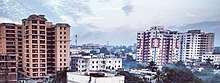
 From top clockwise: Dhanbad Railway Station, Golchakkar, | |
| Nickname(s): 'The Coal Capital of India', 'Koylanchal' | |
 Dhanbad Location of Dhanbad in Jharkhand | |
| Coordinates: 23°48′N 86°27′E / 23.8°N 86.45°ECoordinates: 23°48′N 86°27′E / 23.8°N 86.45°E | |
| Country | India |
| State | Jharkhand |
| District | Dhanbad |
| Government | |
| • Body | Municipal corporation |
| • Mayor | Chandrashekhar Agarwal (BJP)[1][2] |
| Elevation | 222 m (728 ft) |
| Population (2011)[3] | |
| • Metropolitan City | 1,162,472 |
| • Rank | 36th |
| • Metro | 1,196,214 |
| • Metro rank | 42nd |
| Languages | |
| • Official | Hindi, English |
| Time zone | UTC+5:30 (IST) |
| PIN | 826001 |
| Telephone code | +91-326 |
| Vehicle registration | JH-10 |
| Website |
www |
Dhanbad is a city in the Indian state of Jharkhand.[4] It is the second most populated city in Jharkhand.[5] Dhanbad along with its adjacent urban areas ranks 42nd in population amongst other cities in India. Dhanbad shares its land borders with Asansol, West Bengal. Dhanbad has some of the largest coal mines in India[6] and is called Coal Capital of India.[7] Tata Steel, Bharat Coking Coal Limited (BCCL), Eastern Coalfields Limited (ECL) and Indian Iron And Steel Company (IISCO) are some of the companies who operate coal mines in the district.[8][9][10] The engineering institute IIT (ISM), Dhanbad is located in Dhanbad.[11]
Among the rail divisions of Indian Railway, Dhanbad Rail Division is the second-largest in revenue generation after the Mumbai division.[12]
The city has one parliamentary seat and six seats in the Legislative Assembly.
Etymology
The most popular theory of origin of the name Dhanbad is that it is derived from Dhan (धन) and Abad (आबाद), meaning "prospered with wealth" due to being a mineral rich region. Historically the name of Dhanbad was Dhanbaid which seems to have been derived from the word Dhan (paddy) and baid, i.e., the paddy land."Dhanbad" is a paddy land,rich of minerals and also it has the largest rice growing farm in jharkhand
History
The present district used to be a part of Manbhum region and was occupied by Mundari or Kolarian races in the wilderness of South undivided Bihar. In the seventh century A.D. some information is available from the account of the travels of Hieun Tsang. These accounts narrate existence of a powerful kingdom which comprised the district and adjoining areas, ruled by Sasanka.[13]
Manbhum was one of the districts of the East India during the British Raj. The region has thick forests, with rich mineral resources, and had a mixed demographic profile with people from different religious and social groups, including adivasis, particularly the Santals and the Mundas before the city was established.[14] After India’s independence, the district became a part of Bihar state, and upon re-organization of the Indian states in the mid-1950s, the district became a part of the West Bengal. Present Purulia district was carved out of the district of Manbhum.[14]
In the Settlement Report for Manbhum (1928) it was stated that no rock inscriptions, copper plates or old coins were discovered and not a single document of copper plate or palm leaf was found, during the Survey and Settlement operations. The oldest authentic documents produced were all on paper and barely even a hundred years old.[15]
Dhanbad city was in Manbhum district from 1928 up to 1956.[15] However, on 24 October 1956, Dhanbad was declared a District on the Recommendation of the States Reorganization Commission vide notification 1911. This was done under the strong commitment and leadership from a renowned journalist Mr. Satish Chandra. In the year 2006, Dhanbad celebrated 50 years of being an independent District and city. From 1956 to 14 November 2000 it was under Bihar. At present it is in Jharkhand, after the creation of state on 15 November 2000.[16]
Govindpur Block in Dhanbad was a historical place before 1908, this was Anumandal office during British Empire.
In 21st Century discovery of rich deposits of coal in the region caused the city to flourish with wealth but also bought notorious coal-mafia and gang wars[17] which continues to this day with areas of city like Wasseypur being most affected by the conflict.[17]
Geography and climate
| Dhanbad | ||||||||||||||||||||||||||||||||||||||||||||||||||||||||||||
|---|---|---|---|---|---|---|---|---|---|---|---|---|---|---|---|---|---|---|---|---|---|---|---|---|---|---|---|---|---|---|---|---|---|---|---|---|---|---|---|---|---|---|---|---|---|---|---|---|---|---|---|---|---|---|---|---|---|---|---|---|
| Climate chart (explanation) | ||||||||||||||||||||||||||||||||||||||||||||||||||||||||||||
| ||||||||||||||||||||||||||||||||||||||||||||||||||||||||||||
| ||||||||||||||||||||||||||||||||||||||||||||||||||||||||||||
Dhanbad has an average elevation of 227 m (745 ft). Its geographical length (extending from north to south) is 15 miles (24 km) and the breadth (stretching across east to West) is 10 miles (16 km). It shares its boundaries with West Bengal in the eastern and southern part, Dumka and Giridih in the North and Bokaro in the west. Dhanbad comes under the Chota Nagpur Plateau.
Dhanbad features climate that is transitional between a humid subtropical climate and a tropical wet and dry climate. Summer starts from last week of March and ends in mid-June. Peak temperature in summer can reach 48 °C. Dhanbad also receives heavy rainfall. In winter, the minimum temperature remains around 10 °C with a maximum of 22 °C. Damodar River is the main river flowing through the district. Katri, Jamunia, Gobai, Khudia and Irji are the other rivers flowing through the district.
| Climate data for Dhanbad | |||||||||||||
|---|---|---|---|---|---|---|---|---|---|---|---|---|---|
| Month | Jan | Feb | Mar | Apr | May | Jun | Jul | Aug | Sep | Oct | Nov | Dec | Year |
| Average high °C (°F) | 25 (77) |
28 (82) |
33 (91) |
38 (100) |
39 (102) |
35 (95) |
31 (88) |
31 (88) |
31 (88) |
31 (88) |
28 (82) |
25 (77) |
31 (88) |
| Average low °C (°F) | 11 (52) |
14 (57) |
18 (64) |
23 (73) |
25 (77) |
25 (77) |
24 (75) |
24 (75) |
23 (73) |
20 (68) |
16 (61) |
11 (52) |
20 (67) |
| Average precipitation mm (inches) | 17 (0.67) |
18 (0.71) |
18 (0.71) |
22 (0.87) |
49 (1.93) |
192 (7.56) |
342 (13.46) |
311 (12.24) |
282 (11.1) |
105 (4.13) |
7 (0.28) |
5 (0.2) |
1,368 (53.86) |
| Source: IMD | |||||||||||||
Demography
As of 2011 census, Dhanbad city had a population of 1,162,472.[3] Males (614,722) constitute 53% of the population and females (547,750) 47%. It has a sex ratio of 891. Dhanbad has an average literacy rate of 79.47%, higher than the national average of 74.04%: male literacy is 86.14% and female literacy is 71.96%.[3] In Dhanbad, 10.57% of the population is under 5 years of age.
Religion
Hinduism is the dominant religion with over 81% adherents. The minority religions are Islam, Sikhism and Christianity.[3]
Civic administration
Dhanbad is the headquarters of the district and also the headquarters of DMC (Dhanbad Municipal Corporation). DMC was formed as per the State Government Notification dated 1/02/06 with merger of areas Jharia NAC, Sindri, NAC, Chhatandih NAC, ]]Katras NAC. Dhanbad city elects one Member of Parliament. Also some part of the district comes under Giridih seat of Lok Sabha. There are six Legislative Assembly seats; they are Sindri, Baghmara, Dhanbad, Jharia, Nirsa, Tundi.
Dhanbad has District court and Labour Court-Industrial tribunal. Along with Mumbai, Dhanbad is the only city having two Labour Court-Industrial tribunals. Mineral Area Development Authority (MADA) looks after the development of the district.
Economy
Dhanbad is the largest city by population and second largest urban agglomeration in Jharkhand after Jamshedpur.[5]
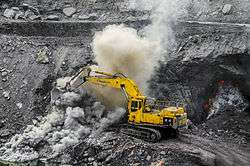
Dhanbad is famous for its coal mines and industrial establishments; the city is surrounded by about 112 coal mines[18] with a total production of 27.5 million tonnes and an annual income of 7000 million rupees through coal business. There are a number of coal washeries present there.
Though managed by a municipal corporation, Dhanbad was listed the least clean of all according to the latest Swachh Sarvekshan of 73 Indian cities in 2016.[19] Indian institute of technology(Indian School of Mines), IIT (ISM) launched Total Waste Solution, or ToWaSo, a waste management start-up.[20] Taking note of the rising pollution in the coal city, the Municipal Corporation of Dhanbad (MCD) is planning to plant trees which can absorb toxic gases from the atmosphere.[21]
Government and PSU organizations
Dhanbad, being the coal capital of India, has several PSUs related to mining and coal.
- Bharat Coking Coal Limited - BCCL is a public sector undertaking (subsidiary of Coal India Ltd.) engaged in mining of coal and allied activities. BCCL meets almost 50% of the total prime coking coal requirement of the integrated steel sector. BCCL was incorporated in January, 1972 to operate coking coal mines operating in the Jharia and Raniganj Coalfields, taken over by the Govt. of India on 16 October 1971 to ensure planned development of the scarce coking coal resources in the country.
- CIMFR, Barwa Road Campus- CMRI, the Central Institute of Mining and Fuel Research (CIMFR) Dhanbad, is a constituent laboratory of Council of Scientific & Industrial Research (CSIR) was aimed to provide R&D inputs for the entire coal-energy chain from mining to Consumption through integration of the core competencies of the two (CFRI and CMRI) premier coal institutions of the country.[22]
- CIMFR, Digwadih Campus, erstwhile CFRI[23]
- CMPF - Coal Mines Provident Fund Organization.[24]
- CCWO - Central Coal Washery organization, unit of BCCL is situated at Saraidhela. which looks after the works of all coal washeries of Bharat Coking Coal Limited.
The Directorate General of Mines Safety is the Indian government regulatory agency for safety in mines and oil-fields is located in the city.[25]
Education
Universities and colleges
- Indian Institute of Technology (Indian School of Mines), Dhanbad, was started by the British in 1926.[11][20]
- Birsa Institute of Technology, Sindri is a government engineering college in Jharkhand.[26]
- SSLNT Women's College is one of the oldest women's science and art college in east India established in 1956.[27][28]
- Patliputra Medical College and Hospital is located in the city as are many other colleges.
- Law College Dhanbad[29] was established in 1976.
- Guru Nanak College[30]
- Raja Shiva Prasad College
Schools
- Carmel School Digwadih
- DAV Public School, Koyla Nagar
- DAV Public School, Mahuda
- Delhi Public School, Dhanbad
- De Nobili School, CMRI
- De Nobili School, Bhuli
- De Nobili School, FRI
- Kendriya Vidyalaya
- Tata D.A.V School, Jamadoba
Jharkhand chief minister Raghubar Das announced the setting up of a university in Dhanbad named after Binod Bihari Mahto. The new university is also expected to serve the higher education needs of students of Bokaro and Giridih.[31] Vinoba Bhave University (VBU) has zeroed in on vacant land inside the premises of RS More College in Govindpur, Dhanbad, for setting up of the proposed Vinod Bihari Mahto Koylanchal University.[32]
Politics
Dhanbad city and district is considered a BJP stronghold with majority of its MPs MLA's being of the party since the 1990s. Chandra Shekhar Agrawal of BJP is the mayor, otherwise known as the first citizen, of Dhanbad Municipal Corporation. He won by the margin of 42,525 votes.[33][34][35]
Raj Sinha of BJP won in the 40-Dhanbad assembly constituency defeating Mannan Malick of Congress in 2014.[36] Pashupati Nath Singh of BJP defeated Mannan Mallik of Congress in 2005, Prasadi Sao of RJD in 2000, and Ramadhar Yadav of JD in 1995. Surendra Prasad Roy of Congress defeated S.K. Shriva of JD in 1990 and Ram Chander Singh of Janata Party in 1985. Yogeshwar Prasad Yogesh of Congress defeated Gopi Kant Bakshi of CPI(M) in 1980 and Kalawati Devi of Janata Party.[37][38]
Dhanbad assembly constituency is part of Dhanbad (Lok Sabha constituency).[39]
Members of Parliament for Dhanbad
| Election | Member | Party | |
|---|---|---|---|
| 1991 | Rita Verma | Bharatiya Janata Party | |
| 1996 | Rita Verma | Bharatiya Janata Party | |
| 1998 | Rita Verma | Bharatiya Janata Party | |
| 1999 | Rita Verma | Bharatiya Janata Party | |
| 2004 | Chandra Shekhar Dubey | Indian National Congress | |
| 2009 | Pashupati Nath Singh | Bharatiya Janata Party | |
| 2014 | Pashupati Nath Singh | Bharatiya Janata Party | |
Transport
Rail
Dhanbad has a very good rail connectivity with the other major parts of the country such as Delhi, Mumbai, Patna, Kolkata, Bhagalpur, Munger, Gaya, Chennai, Ahmedabad, Hyderabad, Kochi, Indore, Bhopal, Gwalior, Jabalpur, Jaipur, Bhubaneswar, Visakhapatnam Jodhpur, Nagpur, Pune, Varanasi, Guwahati etc.

Dhanbad Rail Division comes under East Central Railway zone. Grand Chord rail-line passes through Dhanbad junction, it connects Howrah and New Delhi. CIC rail line starts from Dhanbad and ends at Singrauli in Madhya Pradesh. There is one more rail line passing through the district, it starts at Kharagpur and ends at Gomoh, this rail line comes under South Eastern Railway. Dhanbad is connected with almost all states through rail network. Each and every train through this has a stop at Dhanbad, other than the Sealdah New Delhi & Howrah New Delhi Duronto Exp, which also has a Technical Halt, but not to be used for Commercial Purposes.
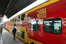
On 1 October 2011, India's first AC double-decker train was flagged off to connect Howrah and Dhanbad. With this India joins the league of Europe and North America that run multi-deck trains. As of October 2011, the train runs daily except Sunday, departing from Howrah at 8:30 am to arrive at Dhanbad at 12:45 pm, and on return trip it departs Dhanbad at 6:30 pm to arrive at Howrah at 10:40 pm. It has a maximum permissible speed of 110 kilometres (68 mi)/hr with stops at Bardhaman, Durgapur, Asansol, Barakar and Kumardhubi on both legs of the route. This new AC design has several features namely stainless steel body, high-speed Eurofima design bogies with air springs and other safety-features.[40][41][42]
Roads
National Highway 2 and National Highway 32 are the major highways passing through Dhanbad.[43] NH 2 is part of Golden Quadrilateral (GQ) highway network; Dhanbad lies in Kolkata-Delhi link of the Golden Quadrilateral network.[44] NH2 is being converted into six lane expressway; NH 32 connects Dhanbad to Bokaro-Jamshedpur.[44]
Private and State buses are available for inter-city traveling.[44]
Air
Dhanbad Airport is used for private small aircraft and helicopters, currently there is no public air-link at the airport. The nearest public airports to Dhanbad are
- Kazi Nazrul Islam Airport, Asansol-Durgapur 85 kilometres (53 mi)
- Birsa Munda Airport, Ranchi 140 kilometres (87 mi)
- Gaya Airport 207 kilometres (129 mi)
- Netaji Subhas Chandra Bose International Airport, Kolkata 269 kilometres (167 mi)
- Lok Nayak Jayaprakash Airport, Patna 271 kilometres (168 mi)
Sports
Cricket is the most popular sport in Dhanbad, followed by Football. Dhanbad is one of the centres where 34th National Games[45] was organised. Cricket Stadiums at present are at Tata Steel Stadium Digwadih, Nehru Stadium Jealgora and Railway Stadium where Ranji Trophy matches are organised. Women's International Cricket were also played at Railway Stadium. Football matches of national level were played at Railway Stadium but now it is converted into Cricket Stadium by the Railway management and Sijua Stadium.
For the preparation of Mission Olympic 2020 and 2024, the Dhanbad District Olympic Games Association is working day and night.
Dhanbad officially became the second town in the state to boast a cricket stadium with floodlights, with the inauguration of floodlights at Tata Digwadih Stadium.[46]
Media
Hindi newspapers are mainly published from the city, among them Hindustan Dainik is the most popular, followed by Prabhat Khabar, Dainik Jagran and Dainik Bhaskar. "Dhanbad Bokaro Live" is published from Dhanbad.
Doordarshan relay station is present in Dhanbad near Koyla Nagar. There are some local news channels in the city such as, Antarkatha which are creative media houses which broadcast on local cable on Dhanbad, Jharia, Bokaro, Chatra, Hazaribag, Kodrma, Ramgarh etc.
FM radio is available as Vividh Bharti Service of All India Radio at 101.8 MHz.
Rivers
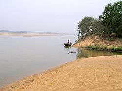
The Damodar is the most important river of the Chota Nagpur Plateau. It rises in Palamu and flows eastward between the plateaus of Ranchi and Hazaribag. It is joined by the Bokaro, the Konar and the Barakar rivers. The Damodar enters Dhanbad district at its confluence with the Jamuria, a stream which marks the western boundary of Dhanbad with Hazaribagh District. Further east, the Damodar is joined by the Katri River which rises in the foot hills below Parasnath and traverses through the Coal-field Area. The Damodar flows for about 77 km. through the district being joined by the Barakar at its eastern border near Chirkunda. The Panchet dam extending to roughly 6 km is built on river Damodar. The hydal station there generates 40,000 K.W. per hour (sicsic).
The Barakar, which forms the northern boundary of the district, traverses about 77 km. In the district. It flows in south westerly direction up to Durgapur and then south till it joins the Damodar near Chirkuda. The Maithon dam is located on this river about 13 km off its confluence with the Damodar. Attached to it is the Maithan Power Station with a generating capacity of 60,000 K.W.H.
Among other small rivers in the district are Gobai, the Ijri, and the Khudia besides the river Katri.
People from Dhanbad
- Anurag Dikshit - born in Dhanbad, ranked 207th-richest person in the world by Forbes in 2006[47]
- Deven Sharma, former global president of Standard & Poor's
- Meenakshi Seshadri, Bollywood actress
- Meiyang Chang, Bollywood actor
- Zeishan Quadri, Bollywood actor, film maker
- Madhurima Tuli, Bollywood and South Indian actress
- Shiv Khera, author and professional speaker
- Randhir Prasad Verma, Indian police officer
- Sambit Patra, National spokesperson, BJP
References
- ↑ "Chandrashekhar is Dhanbad Mayor". Daily Pioneer. 30 May 2015.
- ↑ "BJP split on mayor aspirants". The Telegraph. 1 May 2015.
- 1 2 3 4 5 "Dhanbad City Census 2011 data". Census2011. Retrieved 23 March 2017.
- ↑ "Eleven Indian cities among 100 fastest growing cities in the world". www.merinews.com. Retrieved 17 June 2017.
- 1 2 "Jharkhand Population Sex Ratio in Jharkhand Literacy rate data". www.Census2011.co.in. Retrieved 17 June 2017.
- ↑ "Racketeering in coal: 'Coal crisis' in India presents a highly confusing picture : Cover Story - India Today". India Today. 18 February 2015.
- ↑ "The Sad State of India's Coal Capital". Wall Street Journal. 5 April 2010.
- ↑ "List of Coal Mines:Dhanbad District Of Jharkhand". dhanbad.nic.in.
- ↑ "Coal mines bleed in job mafia wars". The Telegraph. 9 April 2015.
- ↑ "Pollution choking Dhanbad as coal companies flout rules". Times of India. 9 August 2013.
- 1 2 "Mines' school faces big dip in popularity as it readies to don IIT avatar". Times of India. 12 March 2015.
- ↑ "Dhanbad Rail Division OVERVIEW". The Telegraph. Calcutta, India. 4 April 2012. Retrieved 10 October 2013.
- ↑ "DHANBAD DISTRICT OVERVIEW". Archived from the original on 17 March 2011. Retrieved 6 October 2011.
- 1 2 Encyclopædia Britannica, Eleventh Edition, a publication now in the public domain
- 1 2 Dhanbad Introduction/Jharkhand-Dhanbad Sightseeing-Dhanbad Jharkhand Transport-Places of Interest in Dhanbad. Indiatravelite.com. Retrieved on 2012-04-14.
- ↑ BIHAR REORGANISATION ACT,2000
- 1 2 "In real life: Coal mafia gang wars continue in Wasseypur". Hindustan Times. 30 July 2014.
- ↑ LIST OF COAL MINES IN DHANBAD. dhanbad.nic.in
- ↑ "Dhanbad among 10 least clean cities". zeenews.india.com.
- 1 2 "IIT Dhanbad Student Run Organization". iitism.com.
- ↑ "Green belt to fight pollution in Dhanbad". timesofindia.indiatimes.com.
- ↑ "CIMFR". CMRIIndia.nic.in. Archived from the original on 22 September 2014. Retrieved 17 June 2017.
- ↑ "CIMFR, Digwadih Campus". CFRIIndia.nic.in. Retrieved 17 June 2017.
- ↑ "Coal Mines Provident Fund Organisation". www.CMPFO.gov.in. Retrieved 17 June 2017.
- ↑ Directorate General of Mines Safety
- ↑ "13 kids rescued from BIT Sindri hostel mess". Times of India. 15 August 2016. Retrieved 1 June 2017.
- ↑ "SSLNT row over poor Part I results". Times of India. 15 March 2016.
- ↑ "NSUI activist hurls ink at SSLNT head". Times of India. 24 November 2016.
- ↑ "Welcome to Law College Dhanbad". Retrieved 28 July 2015.
- ↑ http://dhanbad.nic.in/Education/colleges.html
- ↑ "CM Das moots varsity tribute". TelegraphIndia.com.
- ↑ "Dhanbad land for new varsity". TelegraphIndia.com.
- ↑ "Mr Builder & Mr Popular A pledge for clean city, clean image". TelegraphIndia.com. Retrieved 17 June 2017.
- ↑ Pioneer, The. "Chandrashekhar is Dhanbad Mayor". DailyPioneer.com. Retrieved 17 June 2017.
- ↑ "Chandra Shekhar Agrawal". www.Facebook.com. Retrieved 17 June 2017.
- ↑ "Jharkhand State Election Results 2009". Travel India Guide. Retrieved 9 April 2010.
- ↑ "State Elections 2006 – Partywise Comparison for 40-Dhanbad assembly constituency of Jharkhand". Election Commission of India. Retrieved 9 April 2010.
- ↑ "State Elections 2006 – Partywise Comparison for 40-Dhanbad assembly constituency of Jharkhand". Election Commission of India. Retrieved 2010-04-09.
- ↑ "Dhanbad Loksabha Constituency (Jharkhand)". India Study Channel.com. Retrieved 2010-04-09.
- ↑ "Double-decker train to run from howrah". Deccan Chronicle. 1 October 2011. Retrieved 2 October 2011.
- ↑ Kanwar, Disha (2 October 2011). "First AC double-decker train flagged off from Bengal". Business Standard. Retrieved 2 October 2011.
- ↑ "India's first AC double-decker train flagged off". Videos News. The Times of India. Retrieved 2 October 2011.
- ↑ National Highways and their Length Archived 27 January 2018 at the Wayback Machine. National Highway Authority of India (NHAI)
- 1 2 3 The Public Website of Dhanbad (Black Diamond City of India). dhanbad.jharkhand.org.in. Retrieved on 2015-08-15.
- ↑ COMPUTER Ed. "Official website for the 34th National Games 2009, Jharkhand - Ranchi - Jamshedpur - Dhanbad - India". Archived from the original on 24 September 2010. Retrieved 28 July 2015.
- ↑ "Glowing Dhanbad stadium". telegraphindia.com.
- ↑ "Anurag Dikshit, The World's Richest People - Forbes.com". www.Forbes.com. Retrieved 17 June 2017.
External links
| Wikimedia Commons has media related to Dhanbad. |
| Wikivoyage has a travel guide for Dhanbad. |