Bhadohi district
| Bhadohi district | |
|---|---|
| District of Uttar Pradesh | |
 Location of Bhadohi district in Uttar Pradesh | |
| Country | India |
| State | Uttar Pradesh |
| Administrative division | Mirzapur |
| Headquarters | Gyanpur |
| Tehsils | 3 |
| Government | |
| • Lok Sabha constituencies | Bhadohi |
| Area | |
| • Total | 1,055.99 km2 (407.72 sq mi) |
| Population (2011) | |
| • Total | 1,554,203 |
| • Density | 1,500/km2 (3,800/sq mi) |
| Demographics | |
| • Literacy | 89.14 per cent |
| Major highways | NH 2 |
| Website | Official website |
Bhadohi district or Sant Ravidas Nagar district is a district of Uttar Pradesh state in northern India. It is the smallest district by area in Uttar Pradesh.[1] The city of Gyanpur is the district headquarters.
History
Ancient period
According to the epic Mahābhārata, the Pandavas escaped from Lakshyagrah through a tunnel and took shelter here at a place called Semradhnath. It is also said that Mata Sita, wife of lord Rama, lived here in the ashram of Maharshi Balmiki when she was abandoned by Lord Rama. Here, Lav and Kush were born and Mata Sita immersed herself in the lap of goddess Earth.
The region is also linked with Sant Ravidas, after whom the district had been given the name Sant Ravidas Nagar. [1]
Medieval period
Bhadohi supposedly gets its name from Bhar Raj of the region which had Bhadohi as its capital, whose traces can be found in the names of ruined mounds and old tanks named after the Bhar rulers, a tributary of Kannauj kingdom, which in the early medieval period was included in the Kingdom of Jaunpur.
During the reign of Mughal Emperor Akbar, Bhadohi was made a dastur and included in the sarkar of Allahabad.
By the fifteenth century the Bhar were overpowered by Monas Rajputs with Sagar Rai as the first head of the clan, and his grandson, Jodh Rai received it as a zamindari sanad (deed) from Mughal Emperor Shah-e-Jahan.
However around 1750 AD due to non-payment of land revenue arrears, Raja Pratap Singh of Pratapgarh, in lieu of his paying the arrears gave the entire pargana to Balwant Singh of Benaras, subsequently he received it directly under a sanad from Nawab Shuja-ud-Daula of Awadh under British influence in 1770 AD.
In 1911, Bhadohi came under first Maharaja of the newly created princely state of Benares ruled by Maharaja Prabhu Narayan Singh and it remained with Benaras till 1947.[2][3][4]
Modern period
Bhadohi was created on 30 June 1994 as the 65th district of the State. It was part of Varanasi district prior to its creation.
The Mayawati government changed this district's name from Bhadohi to Sant Ravidas Nagar (S.R.N.). The Akhilesh Yadav government resolved on 6 December 2014 to change the name back to Bhadohi.[5]
Geography
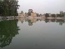
This district is situated in the plains of the Ganges River, which forms the southwestern border of the district. Ganges, Varuna and Morva are the main rivers. The district is surrounded by Jaunpur district to the north, Varanasi district to the east, Mirzapur district to the south, and Allahabad district to the west. The district has an area of 1055.99 km². Rampur is a famous ghat in Bhadohi, and there are some famous temples in Bhadohi: Sita Samahit Sthal (Sitamarhi), Semradhnath Bhole Shankar Mandir, Baba Harihar Nath (Gyanpur), Baba Doodhnath (Gyanpur), Chakwa Mahaveer, Shiv Mandir (Sundarpur), Ghopaila Devi Mandir (Gyanpur), Shani Dham, Tilngeswarnath, Tilanga Shivjatpur and Bhadrakaali temples, and Baba Gangeshwarnath Dham situated in Itahara Uparwar Village.
Divisions
This district is divided into three tehsils, Aurai Tehsil, Bhadohi and Gyanpur, and six blocks,[6] Bhadohi, Suriyawan, Gyanpur, Deegh, Abholi[7] and Aurai.[8]
There are 1075 populated and 149 non-populated villages along with 79 nyay-panchayat and 489 gram panchayats in the district. The district has nine police stations.
Demographics
According to the 2011 census Sant Ravidas Nagar district (as it was then named) had a population of 1,554,203,[10] roughly equal to the nation of Gabon[11] or the US state of Hawaii.[12] This gives it a ranking of 320th in India (out of a total of 640).[10] The district has a population density of 1,531 inhabitants per square kilometre (3,970/sq mi) .[10] Its population growth rate over the decade 2001-2011 was 14.81%.[10] Bhadohi has a sex ratio of 950 females for every 1000 males,[10] and a literacy rate of 89.14%.[10]
Economy
Bhadohi carpets
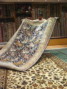
Carpet weaving in Bhadohi-Mirzapur region dates back to the 16th century, during the reign of Mughal Emperor, Akbar[1] and is believed to have established when centuries ago, some Iranian master weavers stopped at Madhosingh village, near Khamaria, in Bhadohi while travelling in India, and subsequently set up looms here.[13]
The present day Bhadohi district is biggest carpet manufacturing centres in India, most known for its hand-knotted carpet. While the Mirzapur-Bhadohi region has the largest number of weavers involved in handmade carpet weaving cluster, engaging around 3.2 million people in the industry, Bhadohi alone employs 2.2 million rural artisans in its 100 percent export-oriented industry.[1] Bhadohi based organisations account for about 75% of the Rs 44 billion of total carpet exports from India, The annual turnover of carpet exports from Bhadohi was Rs 25 billion (approx) in 2010.
In 2010, the carpets of the region received the Geographical Indication (GI) tag, which means carpets manufactured in nine districts of the region, Bhadohi, Mirzapur, Varanasi, Ghazipur, Sonebhadra, Kaushambi, Allahabad, Jaunpur and Chandauli would be tagged with 'handmade carpet of Bhadohi'. Most of the production is aimed at foreign countries.[13]
Well-known carpet types from Bhadohi include cotton Dhurries, Chhapra Mir carpets, Abusan, Persian, Loribaft, Indo Gabbeh but also Nepalese carpets and more recent shaggy type carpets. They are manufactured in various qualities.
References
- 1 2 3 4 "District Census Handbook (Archived version)" (PDF). Directorate of Census Operations (Uttar Pradesh). Archived from RAVIDAS NAGAR (BHADOHI).pdf the original Check
|url=value (help) (PDF) on 14 November 2016. Retrieved 13 August 2017. - ↑ Encyclopaedia of Human Geography (Set of 3 Vols.). Anmol Publications. 2005. p. 107. ISBN 81-261-2444-X.
- ↑ Bayly, Christopher Alan (1988). Rulers, Townsmen and Bazaars: North Indian Society in the Age of British Expansion, 1770–1870. CUP Archive. p. 103. ISBN 0-521-31054-7.
- ↑ "Historical Background of Bhadohi Carpet Industry" (PDF). Shodhganga.
- ↑ "Sant Ravidas Nagar district to be renamed as Bhadohi". India TV. 7 December 2014. Retrieved 16 January 2017.
- ↑ Suraj, Mishra. "wikivillage.in".
- ↑ Abholi, Wikivillage.in
- ↑ Aurai, Wikivillage.in
- ↑ "Sant Ravidas Nagar District Religion Data - Census 2011". www.census2011.co.in. Retrieved 19 March 2018.
- 1 2 3 4 5 6 "District Census 2011". Census2011.co.in. 2011. Retrieved 2011-09-30.
- ↑ US Directorate of Intelligence. "Country Comparison:Population". Retrieved 2011-10-01.
Gabon 1,576,665
- ↑ "2010 Resident Population Data". U. S. Census Bureau. Retrieved 2011-09-30.
Hawaii 1,360,301
- 1 2 "Famed Bhadohi carpet gets GI tag". The Times of India. 9 September 2010.
External links
- Official website
- YouTube: Sita Samahit Sthal, notable temple
Places adjacent to Bhadohi district | ||||||||||
|---|---|---|---|---|---|---|---|---|---|---|
| ||||||||||
Coordinates: 25°20′24″N 82°28′12″E / 25.34000°N 82.47000°E