Sikar
| Sikar | |
|---|---|
| City | |
 Sikar Location in Rajasthan, India  Sikar Sikar (India) | |
| Coordinates: 27°37′N 75°09′E / 27.62°N 75.15°ECoordinates: 27°37′N 75°09′E / 27.62°N 75.15°E | |
| Country | India |
| State | Rajasthan |
| District | Sikar |
| Government | |
| • Type | Federal Republic |
| • Body | Government of Rajasthan |
| Area | |
| • Total | 22.57 km2 (8.71 sq mi) |
| Elevation | 427 m (1,401 ft) |
| Population (2011) | |
| • Total | 237,579 |
| • Density | 11,000/km2 (27,000/sq mi) |
| Languages | |
| • Official | Hindi |
| • Regional | Rajasthani or Shekhawati |
| Time zone | UTC+5:30 (IST) |
| PIN | 332001 |
| Telephone code | 91-1572 |
| Vehicle registration | RJ-23 |
| Literacy | 77.25%(2nd) |
| Distance from Delhi | 280 kilometres (170 mi) (land) |
| Distance from Jaipur | 114 kilometres (71 mi) (land) |
| Climate | Köppen climate classification (Köppen) |
| Avg. annual temperature | 16-20 °C |
| Avg. summer temperature | 45-46 °C |
| Avg. winter temperature | 0-1 °C |
| Website |
www |
Sikar is a city located midway between Agra and Bikaner on the National Highway 11 in the state of Rajasthan in India. It is the administrative headquarters of the Sikar District. Sikar is a historical city and contains many old havelis (large houses with Mughal-era architecture). It is located 114 km from Jaipur, 320 km from Jodhpur 215 km from Bikaner, and 280 km from Delhi.
History
Sikar is a historical city located in Rajasthan state in India. It is famous for its art and culture. Sikar had been the biggest Thikana (Estate) of the Jaipur state. Previously, Sikar was the first Sikarwar ruler of Rajput, the capital town of Thikana Sikar rule by Shekhawat. Sikar is surrounded by the fortified walls consisting of seven “Pols” (gates). These historical gates are named as the Bawari gate, Fatehpuri Gate, Nani Gate, Surajpole Gate, Dujod Gate Old, Dujod Gate New and Chandpole Gate. The primitive name of Sikar was “Beer BhanKa Bass”[1]
Geography and Climate
Geography
Sikar is the district headquarters of Rajasthan's Sikar district, which is situated in the eastern part of Rajasthan. It is located at27°37′N 75°09′E / 27.62°N 75.15°E.[2] It has an average elevation of 427 meters (1401 feet).
Climate
Sikar has a hot, semi-arid climate (Köppen climate classification BSh) and rain occur in the monsoon months, between June and September. The summer months of April to July have an average daily temperature of around 30 °C (86 °F). The maximum temperature during the May & June can reach close to 50 °C (122 °F) with little to no humidity. During the monsoon, there are frequent, heavy rains and thunderstorms, but flooding is not persistent. The winter months of November to February are also harsh, with average temperature ranging from 5–15 °C (41–59 °F) even with little or no humidity. There are, however, several cold fronts that lead to temperatures below freezing −3–0 °C (27–32 °F).
| Sikar | ||||||||||||||||||||||||||||||||||||||||||||||||||||||||||||
|---|---|---|---|---|---|---|---|---|---|---|---|---|---|---|---|---|---|---|---|---|---|---|---|---|---|---|---|---|---|---|---|---|---|---|---|---|---|---|---|---|---|---|---|---|---|---|---|---|---|---|---|---|---|---|---|---|---|---|---|---|
| Climate chart (explanation) | ||||||||||||||||||||||||||||||||||||||||||||||||||||||||||||
| ||||||||||||||||||||||||||||||||||||||||||||||||||||||||||||
| ||||||||||||||||||||||||||||||||||||||||||||||||||||||||||||
Demographics
Sikar City has a population of about 237,579[3] people according to the census of 2011. As per provisional reports of Census India, the population of Sikar in 2011 is 237,579; of which there are approximately 123,156 males and 114,423 females. The sex ratio of Sikar City is 929 females per 1000 males. Regarding education, total literates in Sikar city are 158,413 of which 91,403 are males while 67,010 are females. The average literacy rate of Sikar City is 77.13, male and female literacy status is 86.29 and 67.37 respectively. The total population of children (0-6) in Sikar City is about 32,189, consisting of 17,236 boys and 14,953 girls. The child sex ratio of girls is 868 per 1000 boys.
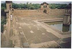
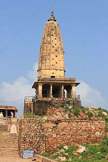
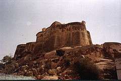
Places of Interest
- Rajkumar Hardyal Singh Government Museum Sikar
- Sikar Fort
- Sai Dham (Mundwara)
- Sri Digamber Jain Bada Mandir, Bawari Gate
- Madho Niwas Kothi
- Radha Damodar Mandir
- Bolta Balaji mandir
- Rani Mahal
- Devi Pura Balaji
- Santoshi Mata Mandir
- Maroo Park
- Nehru Park
- Ganesh Mandir, Fatehpuri Gate
- Temple of Gopinathji, Subhash Chowk
- Temple of Raghunathji, Bawari Gate
- Diwan Ji Ki Nashiya, Jatiya Bazar
- Diwan Ji ki Haveli
- Shobhagyavati mandir
- Shri Ram Hanuman mandir (Radha kishan pura Sikar)
- Mata Mansa Devi Temple, Hasampur
- Shakambhari Mata Mandir
- Shyam Mandir Khatu
- Samolai balaji Temple
- Deeppura Rajaji Fort
- Maa Durga Mandir Bhairupura Jagir
Administration
Sikar city is governed by a Municipal Corporation, which comes under the Sikar Urban Agglomeration. Sikar city is divided into 45 wards. Although Sikar city has a population of 237,579, its urban/metropolitan population is 244,563. The Sikar metropolitan area includes Chandrapura (Rural), Radhakrishnpura, Samarthpura, Shivsinghpura and Sikar city. The current Member of Parliament from Sikar is Swami Sumedhanand Sarsawati elected in May 2014.
Modes of Transportation
Rail
Sikar Junction railway station comes within the territory of the North Western Railway. Sikar City is connected through a broad gauge line to Jhunjhunu, Rewari, Delhi, and Churu. Sikar - Jaipur track is under construction. A section of 30 km has been completed up to Palsana. 80 km will be completed by March 2019.
Railway Minister Suresh Prabhu on September the 1st, 2015 (Tuesday) flagged off two trains to mark the completion of Rs. 260 crore gauge conversion of the 122 km Loharu-Sikar railway line in Rajasthan. Both trains were flagged off by Prabhu through remote control by an organizing video conferencing between Rail Bhawan, in New Delhi and Sikar. Prabhu pointed out that sufficient funds have been provided in 2015-16 to complete this project, i.e., Jaipur-Ringas-Churu by March, 2017.[4]
The bi-weekly rail service between Sikar and Delhi started on September 2, 2015, as Sikar - Delhi Sarai Rohilla Express was inaugurated by Suresh Prabhu.
Road
Sikar is well connected by roads from all the major cities of Rajasthan and nearby states. A four-lane national highway NH-11 passes through the centre of the city. NH-11 connects Sikar with Jaipur and Bikaner. The western freight corridor will also pass through Sikar, as a main project of the central government. Kotputali Kuchaman Mega Highway also passes through Sikar.
Air
The nearest airport to Sikar City is Jaipur International Airport, which operates daily flights to Delhi, Mumbai, Hyderabad, Bangalore, Pune, Indore, Ahmedabad, Chennai, Guwahati, Kolkata, Udaipur, Dubai, Sharjah, Muscat. A new airport is proposed at Shahpura (a town in Jaipur district) that is very close to Sikar. A small air strip at Tarpura village is also available for the landing of small private planes against payment.
Education
Sikar has become a major education hub of Rajasthan. Along with numerous government colleges providing art, science, and commerce education, a number of private educational institutes have also opened up. Shri Kalyan Government College is the largest college of Sikar. Sikar University was opened in 2013 by the Rajasthan government. Sikar has many private engineering colleges as well. Arawali Veterinary College, the only recognized veterinary college in the private sector is also located in Sikar on NH-11, Sikar-Jaipur Highway.
See also
References
- ↑ Sikar-Rajasthan. "History|Sikar Rajasthan,Sikar-Rajasthan". sikar.rajasthan.gov.in. Retrieved 2018-07-13.
- ↑ "Falling Rain Genomics, Inc a – Sikar". Fallingrain.com. Retrieved 2011-12-29.
- ↑ "Census 2011 data – Sikar city". census2011.co.in. Retrieved 2011-12-29.
- ↑ "Railway Minister flags off new Train on newly build Loharu-Sikar broad gauge line", Rail News (Sept. 1 2015)
5.http://members.iinet.net.au/~royalty/ips/p/pahargarh.html 6.http://members.iinet.net.au/~royalty/ips/s/sikar.html
7. http://fistfullofmemories.blogspot.com/2014/08/the-sikarwar-rajputs-of-india.html
External links
| States | ||
|---|---|---|
| Union Territories | ||
| Related topics | ||
| Outline |  | ||||||||||||||
|---|---|---|---|---|---|---|---|---|---|---|---|---|---|---|---|
| Governance | |||||||||||||||
| Divisions and districts |
| ||||||||||||||
| Major cities | |||||||||||||||
| Related templates |
| ||||||||||||||