Kanpur division
| Kanpur division, Uttar Pradesh | |
|---|---|
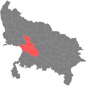 | |
| Districts | 1. Kanpur Dehat, 2. Kanpur Nagar, 3. Auraiya, 4. Kannauj, 5. Farrukhabad, 6. Etawah |
| Area | 14,810 km2 (5,720 sq mi) |
| Population | 12,873,369 (2011)[1] |
Kanpur division is an administrative geographical unit of Uttar Pradesh state of India. Kanpur is the administrative headquarters of the division. Currently (2005), the division consists of districts of:
History of administrative districts in Kanpur Division
Kanpur division was earlier part of the Allahabad division. In the year, 2000, the Mayawati government did a major reshuffle of the Allahabad division, and a separate Kanpur division was created.
The Kanpur district itself was bifurcated into Kanpur Dehat and Kanpur Nagar. Kanpur Dehat was renamed as Ramabai Nagar, after the name of Ramabai (1896-1935), the wife of Bhimrao Ramji Ambedkar. It is famous that the secret of success in life of B.R. Ambedkar was his wife Ramabai. In 2012 the name was changed back to Kanpur Dehat.
| Rank | Metropolitan Area | Area (km sq.) | 2011 (Provisional figures) | Coverage |
|---|---|---|---|---|
| 1 | Kanpur | 450 | 2,920,067 | Includes Kanpur Cantonment and Chakeri |
| 2 | Farrukhabad | 40 | 275,754 | Includes Fatehgarh |
| 3 | Etawah | 35 | 256,790 | |
| 4 | Auraiya | 25 | 64,598 | |
| 5 | Kannauj | 20 | 71,530 | |
| 6 | Ghatampur | 12 | 35,496 | |
| 7 | Chhibramau | 10 | 50,279 | |
| 7 | Bharthana | 10 | 38,781 |
Cities by GDP
Coordinates: 26°28′12″N 80°19′48″E / 26.47000°N 80.33000°E
References