Jind
| Jind | |
|---|---|
| City | |
 Jind  Jind | |
| Coordinates: 29°19′N 76°19′E / 29.317°N 76.317°ECoordinates: 29°19′N 76°19′E / 29.317°N 76.317°E | |
| Country | India |
| State | Haryana |
| District | Jind |
| Municipality | Jind |
| Division | Hisar |
| Named for | Jayanti Devi |
| Talukas | Jind Sadar |
| Government | |
| • Body | Municipal Committee, Jind |
| • Member of Legislative Assembly | Hari Chand Middha |
| Elevation | 227 m (745 ft) |
| Population (2011) | |
| • Total | 167,592 |
| • Density | 440/km2 (1,100/sq mi) |
| Languages | |
| • Official | Hindi, Haryanvi, Punjabi |
| • Regional | Haryanvi (Western Hindi) |
| Time zone | UTC+5:30 (IST) |
| PIN | 126102 |
| Railway station code | JIND |
| Telephone code | 91-1681 |
| ISO 3166 code | IN-HR |
| Vehicle registration | HR-31, HR-56 (Commercial) |
| Nearest capitals | New Delhi, Chandigarh |
| Sex ratio | 877 ♂/♀ |
| Literacy | 100% |
| Lok Sabha constituency | Sonipat |
| Vidhan Sabha constituency | Jind City |
| Planning agency | HUDA(Haryana Urban Development Authority) |
| Civic agency | Municipal Committee, Jind |
| Climate | Cw (Köppen) |
| Precipitation | 550 millimetres (22 in) |
| Website |
www |
Jind is a city in the Indian state of Haryana. It is the heart of Haryana. It is one of the oldest districts of Haryana. Rani Talab is the major tourist place Pandu-Pindara and Ramrai are the main devotional places attracting devotees for Amavasya bath. The fort of Jind was built by King Ganpat Singh in 1775 AD. CBI judge Jagjeet Singh Lohan belong to Jind
Origin and etymology
as some historian states, jind riyasat is being surfaced by the sikh maharaja ranjeet singh on the name of his youngest queen and mother of the prince duleep singh "maharani jind kaur", as still we found the archeological proof to support the claim, jind is very near to the patiala riyasat so the city itself get its name by maharani jind kaur.
mythological Jind name came up from Jaintapuri. It is also said that this town had been founded at the time of the Mahabharata. According to an old saying, the Pandavas built the Jayanti Devi Temple in honour of Jainti Devi (the goddess of victory), offered prayers for success, and then launched the battle with the Kauravas. The town grew up around the temple and was named Jaintapuri (Abode of Jainti Devi) which later on came to be known as Jind.
History
Raja Gajpat Singh, a great grandson of Phul, the founder of the Phulkian Misl, established an independent Sikh kingdom by seizing with Sikh armed forces a large tract of country which included the territory occupied by the present district of Jind from the Afghan invader and governor Zain Khan in 1763 and made Jind city, the capital of the state in 1776. He made a fort here in 1775. Later, Sangrur was chosen as capital of Jind State by Raja Sangat Singh (reigned 1822 to 1834). After independence, Jind State was merged with the Indian union and the territory of the present district became part of Sangrur district of Patiala and East Punjab States Union on 15 July 1948. At the time of its creation of Haryana state on 1 November 1966, Sangrur district was bifurcated and its Jind and Narwana tehsils were merged to form Jind district, one of the seven districts of the newly formed state. Jind tehsil was bifurcated to two tehsils: Jind and Safidon in 1967.
Geography
Jind is located at 29°19′N 76°19′E / 29.32°N 76.32°E.[1] It has an average elevation of 227 metres (744 feet). In the East The Sonipat District is located. In South Rohtak And Bhiwani And in West Hisar and in north west Narwana is located.
Demographics
As of 2011 India census,[2] Jind city had a population of 166,225. Males constituted 53.3% and females 46.7% of the population respectively. Sex ratio is measured at 877 compared to national average 940. The sex ratio for the 0 to 6 year age-group is worse at 831 compared to national average 918. Jind had an average literacy rate of 74%, higher than the national average of 64.3%. Male literacy was 80%, and female literacy was 67% . In Jind, children under six years of age numbered 18,825 and were 11.3% of the population in 2011.[2][3] Haryanavi, Hindi and Punjabi are the languages spoken by most of the people.
Industry
With the emergence of Haryana as a separate State in 1966, the process of industrialization in the district began. Several small-scale industrial units for the manufacture of radio and electrical good, fabrication of cement jallis, soap and candles, etc., were set up in urban areas. Some more important units manufacturing agricultural implements, chemicals, thermometers, surgical cotton, foundries, screws, plastic products, paper-board, coke briquettes, etc. The biggest Industry is saint gobain gyproc india ltd, were established after 1968. The first large-scale industrial unit was the Milk Plant at Jind, which came into existence in 1970. Another unit for the manufacture of steel products was set up in 1973. Industry in the district received a further fillip with the establishment of a cattle feed plant in 1974.
Education
There are numerous schools, and colleges in Jind. These include specialist institutions for subjects such as engineering and Management, Professional Institute in Jind
- CHAUDHARY RANBIR SINGH UNIVERSITY (JIND). Website http://crsujind.org/
- Jind Institute of Engineering & Technology.
- Jind Polytechnic College.
- Indus Institute of Engineering & Technology. Website www.iietjind.com/
- Haryana Agriculture and Training Institute.
Some other Institute
- Government P.G College.
- Priyadarshini Women College.
- C.R Kishan College.
- Hindu Girls College.
- Govt College Alewa,Jind
- Govt College Julana,Jind
- Techno India Teachers Training School Jind
School
- Government senior secondary school
- S D School
- Maharaja Senior secondary School
- DAV senior secondary School
- MLN senior secondary School
- Ekta High School
- Indus public school
- lord shiva senior secondary school
- Techno India Public School Jind
Railways and Roadways
Jind Junction railway station is a railway junction on Delhi-Rohtak-Narwana-Jakhal section of Delhi-Fazilka line that connects Delhi to Punjab. Another railway line connects it to safidon- Panipat. A new railway line is being constructed from Jind to Gohana. A new upcoming railway line is jind-narnaul-hansi. Trains that stop at Jind Junction, Jind City, Narwana Junction railway stations connect it to many Indian cities. Some of the trains are:
- 11449/11450 Jabalpur Jammu Tawi Express (Jabalpur — Jammu Tawi)
- 12137/12138 Punjab Mail (Mumbai Cst — Firozpur Cantt)
- 12455/12456 Shri Ganganagar - Delhi S Rohilla AC SF (Shri Ganganagar — Delhi)
- 12481/12482 Intercity Exp (Old Delhi – Shri Ganganagar)
- 13007/13008 U A Toofan Exp (Shri Ganganagar — Howrah)
- 14035/14036 Dhauladhar Exp (Pathankot — Delhi)
- 15609/15610 Avadh Assam Exp (Lalgarh Junction — Gauhati)
- 16031/16032 Andaman Exp (Chennai Central — Jammu Tawi)
- 16317/16318 Himsagar Exp (Jammu Tawi — Kanyakumari)
- 16687/16688 Navyug Exp (Mangalore Central — Jammu Tawi)
- 19023/19024 Janata Exp (Mumbai Central — Firozpur Cantt)
- 12033/12034 New Delhi - Ludhiana
- 12043/12044 New Delhi - Moga
- 12047/12048 New Delhi - Bathinda
It is well connected by the road services as well. Privately owned buses run for short routes like jind to Narwana, Panipat, bhiwani, rohtak, safidon. Long route buses also originate and suspend here. It is situated on the busy route of delhi to patiala and on National Highway 71. Few bus routes are as:
- Jind to Hisar
- Jind to ISBT Delhi
- Jind to Amritsar
- Jind to Panipat
- Jind to Gurgaon
- Jind to Chandigarh
Nearest airport is IGI Airport, New Delhi which is at a distance of somewhat 3 or 3½ hours ride of car.
Visitor attractions
Religious places in Jind include:
- Ramrai Popular Village In Jind , [ Ramhardyh Tirth ] [ Parsuraam Mandir ] [ Baba Gudad Temple ]
- Baba Gaibi Sahab Mandir Bhongra
- BABA MANSNATH TEMPLE AT CHHATTAR
- Rani Talab
- Asvini Kumara Tirtha Assan
- Bhuteshwara Temple
- Baba Ponkar Temple(Ponkar Kheri)
- Ekahamsa
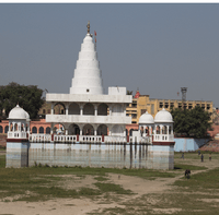
- Jayanthi Devi Temple
- Munjavata Tirth
- Pindara Tirtha (in series of 48 kos parikrama of Kurukshetra)
- Pushkara Tirtha(Ponkar Kheri)
- Ramsar Tirtha(Kuchrana Kalan)
- Tirtha
- Vanshmoolak Tirtha (Barsola)
- Varaha Tirtha
- Yakshini Tirtha
- Dada Khera (Jajwan)
- Bitha Mandir-Naguran
- muana Village Mata Mandir
- Jamni jamdgni rishi mandir(prachin tirth sathal)
- Gurudwara Shri Guru TegBahadur Sahib
- Baba Samadh Wala (Dhanda Kheri)
- Dada Khera (Dhanda Kheri)
- SHIV Ji Mandir (Dhanda Kheri)
- Rajpura (Bhain)
Ramrai village is located 8 kilometers west of Jind. Rajpura anothr village near it is also a well organized and clean village in the village "Dr. BR Ambedkar Community Center, Rural Secretariat, Government School, Hospital etc. Public Institute. Here in ramrai ,is the famous Parshuram Tirtha temple & like the Pushkar Temple of Pankari Khedi, the Gobind Kund of Mahabharata, where "Baba Gulab Giri Mandir" is located on its shore. Govind Kund is of the opinion that Shri Krishna stayed here for 21 days from Krishna Pandavas who came to discover Duryodhana. Manashakumas are fulfilled here and it is situated in the Devbhoomi of Kurukshetra, where after the rituals of the bones do not have to be immersed.(by shubham garg
Google map- https://goo.gl/maps/zgri2xRoguG2
See also
References
- ↑ "Maps, Weather, Videos, and Airports for Jind, India". Fallingrain.com. Retrieved 2012-10-19.
- 1 2 "View Population". Censusindia.gov.in. Retrieved 2012-10-19.
- ↑ "Census of India 2001: Data from the 2001 Census, including cities, villages and towns (Provisional)". Census Commission of India. Archived from the original on 2004-06-16. Retrieved 2008-11-01.
www.technicalrevolution.in