Vaishali district
| Vaishali district | |
|---|---|
| District of Bihar | |
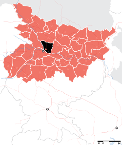 Location of Vaishali district in Bihar | |
| Country | India |
| State | Bihar |
| Administrative division | Tirhut |
| Headquarters | Hajipur |
| Government | |
| • Lok Sabha constituencies | Hajipur, Vaishali |
| • Assembly seats | Hajipur, Lalganj, Vaishali, Mahua, Raja Pakar, Raghopur, Mahnar, Patepur |
| Area | |
| • Total | 2,036 km2 (786 sq mi) |
| Population (2011) | |
| • Total | 3,495,021(68th rank in India 640 district) |
| Demographics | |
| • Literacy | 66.60 per cent |
| • Sex ratio | 895 |
| Major highways | NH 19, NH 77, NH 103 |
| Website | Official website |
Vaishali district is a district in Bihar, India. It is a part of Tirhut division.[1]
History
Ancient Vaishali
Vaishali derives its name from King Vishal. Even before the advent of Buddhism and Jainism, Vaishali was the capital of the vibrant Vajji confederation, since before the birth of Mahavira (c. 599 BC), which suggests that it was perhaps the first republic in the world, similar to those later found in ancient Greece.[2] In that period, Vaishali was an ancient metropolis and the capital city of the republic of the Vajji confederation of Mithila, which covered most of the Himalayan Gangetic region of present-day Bihar. Very little is known about the early history of Vaishali. The Vishnu Purana records 34 monarchs of Vaishali, the first being Nabhaga, who is believed to have abdicated his throne over a matter of human rights and believed to have declared: "I am now a free tiller of the soil, king over my acre." The last among the 34 was Sumati, who is considered a contemporary of Dasharatha, father of the Hindu god, Rama.
Numerous references to Vaishali are found in texts pertaining to both Jainism and Buddhism, which have preserved much information on Vaishali and the other mahajanapadas. Based on the information found in these texts, Vaishali was established as a republic by the 6th century BCE, prior to the birth of Gautama Buddha in 563 BCE, making it the world's first republic.
Mahavira was born in Vaishali. Gautama Buddha delivered his last sermon at Vaishali and announced his Parinirvana there. Vaishali is also renowned as the home of Amrapali, a great courtesan who appears in many folktales as well as in Buddhist literature. Amrapali became a disciple of Gautama Buddha.
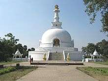
A kilometre away is Abhishek Pushkarini, the coronation tank. The sacred waters of the tank anointed the elected representatives of Vaishali. Next to it stands the Japanese temple and the Vishwa Shanti Stupa built by the Nipponzan-Myōhōji-Daisanga sect, a Japanese new religion. A small number of śarīra found in Vaishali have been enshrined in the foundation and in the chhatra of this stupa. Near the coronation tank is Stupa 1 or the Relic Stupa. Here the Licchavis reverentially encased one of the eight portions of Buddha's relics, which they received after his Parinirvana. After his last discourse, Buddha set out for Kushinagar, but the Licchavis kept following him. Buddha gave them his alms bowl but they still refused to return. The Master created an illusion of a river in spate which compelled them to go back. This site can be identified with Deora in modern Kesaria, where Ashoka later built a stupa. Ananda, the favourite disciple of the Buddha, attained Nirvana in the midst of the Ganges outside Vaishali.
Post-Independence
Vaishali became a district when it was split from Muzaffarpur in 1972.[3]
Geography
Vaishali district occupies an area of 2,036 square kilometres (786 sq mi),[4]
Economy
In 2006 the Ministry of Panchayati Raj named Vaishali one of the country's 250 most backward districts (out of a total of 640).[5] It is one of the 36 districts in Bihar currently receiving funds from the Backward Regions Grant Fund Programme (BRGF).[5]
Sub-divisions
Vaishali district comprises the following Sub-Divisions:
- Hajipur
- Mahnar
- Mahua
Blocks: 1) Mahnar, 2) Vaishali, 3) Bidupur, 4) Goraul, 5) Raghopur, 6) Lalganj , 7) Hajipur, 8) Mahua, 9) Jandaha , 10) Patepur, 11) Sahdeibuzurg, 12) Bhagwanpur, 13) Chehrakala, 14) Rajapakar, 15) Patedhi-Belshar, 16) Desri
Other Famous Places:
- Daudnagar Chakgadho (Bidupur Block): one of largest Gram-panchayat of vaishali district and economically good in comparison to other gram-panchayats. It is the birthplace of Freedom fighter and Ex-MLA of Raghopur Shri (Late) Babulal Shashtri. Having all kinds of amenities and infrastructural facilities which are required for ideal gram-panchayat.
Connectivity: Hajipur-Mahnar Road (Falls in Hajipur-Mahnar Road), Distance from Hajipur: 11 km, Distance from Bidupur: 2 km, Local Police Station: Bidupur (2 km), Public Sector Bank Available: Allahabad Bank Ltd.(CBS Banking), Shopping Complex: Sri Laxmi Market, Famous Person: Manish Chaudhary
- Sarai (Lalganj Block):
Connectivity: Hajipur-Muzaffarpur Road
- Jadhua (Hajipur Block): developed as sub-urban of Hajipur, Gandhi Setu Starts from here.
Famous sites: Old gudri Bazar, Mamu Bhanja Mazar, Connectivity: Patna 7 km, Hajipur 3 km,
- Prataptand: It is around 18 km from Hajipur and 5 km from Bhagwanpur, famous for a very old and beautiful ram temple called as Raghav mandir. A big fair is held here on the occasion of ram navmi, the birth day of Lord Rama.
Demographics
According to the 2011 census Vaishali district has a population of 3,495,021,[6] roughly equal to the nation of opurPanama[7] or the US state of Connecticut.[8] This gives it a ranking of 86th in India (out of a total of 640).[6] The district has a population density of 1,717 inhabitants per square kilometre (4,450/sq mi) .[6] Its population growth rate over the decade 2001-2011 was 28.58%.[6] Vaishali has a sex ratio of 892 females for every 1000 males,[6] and a literacy rate of 66.60%.[6]
Culture
Main festival is Chhath Puja, normally celebrated in the month of October or November. Holi and Eid are also important festivals of Vaishali.
Flora and fauna
In 1997 Vaishali district became home to the Barela Salim Ali Zubba Saheni Wildlife Sanctuary, which has an area of 2 km2 (0.8 sq mi).[9]
See also
References
- ↑ http://tirhut-muzaffarpur.bih.nic.in Archived 2015-03-16 at the Wayback Machine.
- ↑ "Archived copy". Archived from the original on 2008-12-23. Retrieved 2008-12-01.
- ↑ Law, Gwillim (2011-09-25). "Districts of India". Statoids. Archived from the original on 2011-10-17. Retrieved 2011-10-11.
- ↑ Srivastava, Dayawanti et al. (ed.) (2010). "States and Union Territories: Bihar: Government". India 2010: A Reference Annual (54th ed.). New Delhi, India: Additional Director General, Publications Division, Ministry of Information and Broadcasting (India), Government of India. pp. 1118–1119. ISBN 978-81-230-1617-7.
- 1 2 Ministry of Panchayati Raj (September 8, 2009). "A Note on the Backward Regions Grant Fund Programme" (PDF). National Institute of Rural Development. Archived from the original (PDF) on April 5, 2012. Retrieved September 27, 2011.
- 1 2 3 4 5 6 "District Census 2011". Census2011.co.in. 2011. Archived from the original on 2011-06-11. Retrieved 2011-09-30.
- ↑ US Directorate of Intelligence. "Country Comparison:Population". Archived from the original on 27 September 2011. Retrieved 2011-10-01.
Panama 3,460,462 July 2011 est.
- ↑ "2010 Resident Population Data". U. S. Census Bureau. Archived from the original on 2013-10-19. Retrieved 2011-09-30.
Connecticut 3,574,097
- ↑ Indian Ministry of Forests and Environment. "Protected areas: Bihar". Archived from the original on August 23, 2011. Retrieved September 25, 2011.
External links
- Vaishali district, Official website
- Vaishali district at Govt. of Bihar, website.
- Vaishali Information Portal
- Official Website of Tirhut Division
Places adjacent to Vaishali district | ||||||||||
|---|---|---|---|---|---|---|---|---|---|---|
| ||||||||||
Railways in Bihar | |||||||||||
|---|---|---|---|---|---|---|---|---|---|---|---|
| Network Lines Sections |
| ||||||||||
| Rail Bridges | |||||||||||
| |||||||||||
| State symbols | |
|---|---|
| History |
|
| Administration | |
| Overviews | |
| Divisions and districts | |
| Cities | |
| Municipal Corporation |
|
| Poltics | |
| Culture | |