Sonbhadra district
Coordinates: 24°41′23″N 83°3′55″E / 24.68972°N 83.06528°E
| Sonbhadra district | |
|---|---|
| District of Uttar Pradesh | |
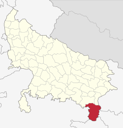 Location of Sonbhadra district in Uttar Pradesh | |
| Country | India |
| State | Uttar Pradesh |
| Administrative division | Mirzapur |
| Headquarters | Robertsganj |
| Tehsils | Robertsganj, Ghorawal, Dudhi |
| Government | |
| • Lok Sabha constituencies | Robertsganj |
| • Assembly seats | Robertsganj, Ghorawal, Obra, Dudhi |
| Area | |
| • Total | 6,788 km2 (2,621 sq mi) |
| Population (2011) | |
| • Total | 1,862,559 |
| • Density | 270/km2 (710/sq mi) |
| Demographics | |
| • Literacy | 64 percent |
| • Sex ratio | 918 |
| Major highways | NH 7, NH 75, SH 5A |
| Website | Official website |
Sonbhadra or Sonebhadra is the second largest district of Uttar Pradesh, India. Sonbhadra is the only district in India which borders four states namely Madhya Pradesh, Chhattishgarh Jharkhand and Bihar. The district has an area of 6788 km² and a population of 1,862,559 (2011 census), with a population density of 270 persons per km².It lies in the extreme southeast of the state, and is bounded by Mirzapur District to the northwest, Chandauli District to the north, Kaimur and Rohtas districts of Bihar state to the northeast, Garhwa district of Jharkhand state to the east, Koriya and Surguja districts of Chhattisgarh state to the south, and Singrauli district of Madhya Pradesh state to the west. The district headquarters is in the town of Robertsganj.Sonbhadra district is an industrial zone and it has lots of minerals like bauxite, limestone, coal, gold etc.
In 2017 Uttar Pradesh's chief minister Yogi Adityanath gives recognition to "Sonbhadra" as a tourist attraction hub in Purvanchal region and further promoted by Uttar Pradesh Tourism Dept.
History
Based on evidence from religious and cultural perspectives of Ramayana and the Mahabharat, Huyen found here is the cultural symbol. By Jarasandh many rulers in the Mahabharat were was maintained prisoner here. The Valley of Son River abounds in caves which were the earliest dwellings of the primeval inhabitants. It is said that 'Bhars' had settlements along with Chero, Searis and Kharwar communities in the district up to 5th century there was the rule of 'local' kings on Vijaygarh Fort. This district was famous as second Kashi during 11th to 13th century. In the 9th century B.C., the Brahmadutt dynasty was subdivided by Nagas. Kushan and Nagas also held supremacy over this region before the advent of the Gupta period. After the death of Harshvardhan in the latter half of the 7th century, it remained under the control of the Gurjara-Pratihars till 1025 before they were driven out by Mahmud of Ghazni. This area was under the administration of various Governors of Mughal emperors. Some of the forts such as Agori Fort were under the control of Madan Shah.
During the 18th century, the district came under the control of the Narayan rulers of Benares State, who built or occupied several fortresses in the district. In the decade after 1775, the British took over administrative control of most of the territory of the rajas of Benares. The British district of Mirzapur included present-day Mirzapur and Sonbhadra districts, with all of present-day Sonbhadra district included in Robertsganj tehsil.
In 1989, Sonbhadra district was divided from Mirzapur district.
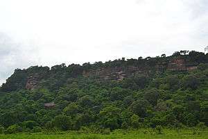
The forts Located in the district
- Agori Fort
- Vijaygarh Fort
- Sodhrigarh Durg

The heroine of Famous Novel Chandrakanta written by Devaki Nandan Khatri was the princess of Vijaygarh and the daughter of king Jay Singh.
Geography
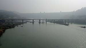
The northern part of the district lies on a plateau of the Vindhya Range, and is drained by tributaries of the Ganges including the Belan and Karmanasha rivers. South of the steep escarpment of the Kaimur Range is the valley of the Son River, which flows through the district from west to east. The southern portion of the district is hilly, interspersed with fertile stream valleys. The Rihand River, which rises to the south in the highlands of Surguja district of Chhattisgarh, flows north to join the Son in the center of the district. The Govind Ballabh Pant Sagar, a reservoir on the Rihand, lies partly in the district and partly in Madhya Pradesh. East of the Rihand, the Kanhar River, which originates in Chhatisgarh, flows north to join the Son.
The district has historic, cultural, and ecological affinities with the Bagelkhand region. Robertsganj is the district headquarters.
Climate
Sonbhadra has a relatively subtropical climate with high variation between summer and winter temperatures. The average temperature is 30 °C–46 °C in the summer and 2 °C–15 °C in the winter. The weather is pleasant in rainy season from July to October.
Ecology
The portion of the district north of the Son River lies in the Lower Gangetic plains moist deciduous forests ecoregion. The portion south of the Son lies in the Chhota Nagpur dry deciduous forests ecoregion.
Kaimoor Wildlife Sanctuary lies mostly within the district, reaching generally east and west along the spine of the Kaimur Range, and extending to the Son River at its eastern end.
Economy

The district has many electrical power stations around Govind Ballabh Pant Sagar. NTPC has twocoal-based thermal power plants, being Singrauli Super Thermal Power Station and Rihand Thermal Power Station at Renukut. Other power stations are at Anpara (UPRVUNL), Obra (UPRVUNL), Renusagar (Hindalco) and Pipri-Hydro (UPRVUNL). NCL (a branch of Coal India Limited) has its headquarters and many coal mines in this region.
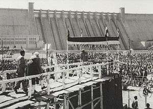
Hindalco has a major aluminium plant at Renukut. Owing to the limestone hills, initially one cement factory was established at Churk in 1956. Another cement factory started at Dala in 1971, with an ancillary unit at Chunar from 1980. A big dam constructed at Pipri in 1961 is named Rihand Dam; another small dam was constructed at Obra in 1968.
The Birla group set up an aluminum plant at Renukut. The company set up its own power plant at Renusagar in 1967 and started a company in Renukut called HiTech Carbon. Another industrial group initiated a company in Renukut named Kanoria Chemicals, which produces chemicals and later it started own power plant at Renukut in 1998.
In 2006 the Ministry of Panchayati Raj named Sonbhadra one of the country's 250 most backward districts (out of a total of 640).[1] It is one of the 34 districts in Uttar Pradesh currently receiving funds from the Backward Regions Grant Fund Programme (BRGF).[1]
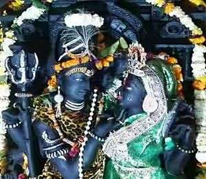
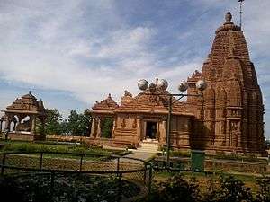
Tourist attraction
Historical places
Nature
Temples
Transport
By air
- Muirpur Airport at Myorpur, a private airport used by chartered and private planes.
- Varanasi International Airport in Varanasi.
Flights are available to all major Indian cities including Delhi, Mumbai, Kolkata, Lucknow, Agra, Bangalore, Chennai, Patna, Khajuraho, Hyderabad, Gaya, etc. International connections are Bangkok, Colombo, Hong Kong and Kathmandu.
By train
- Mirzapur Railway Station.
- Sonbhadra Railway Station.
- Chopan Railway station.
- Obra Railway station.
- Renukoot Railway station near RIHAND DAM.
- Anpara Railway station.
- Singrauli Railway station.
- Shaktinagar Railway station.
- Varanasi Railway station.
- Dudhi Railway station.
The city is connected by rail to Delhi, Allahabad, Ranchi and Patna. Some notable trains passing through the district are Muri express (Jammu Tawi - Delhi - Tata Nagar), Jharkhand Swarna Jayanti Express/12873(Hatia - Kanpur - Delhi), Triveni Express (Bareilly - Lucknow - Shaktinagar/Singrauli/barwadih) Bhopal Express(Bhopal-Howrah)weekly and Shaktipunj Express/11448(Howrah-Bokaro - Chopan- Jabalpur).Intercity Express/03346 (Singrauli- Chopan-Varanasi).
By road
Robertsganj, the headquarters of Sonbhadra, is located about 88 km from the city of Varanasi which has the nearest airport. Robertsganj is well connected to Lucknow, Allahabad, Varanasi, Mirzapur, Gorakhpur, Faizabad, Ambikapur Sasaram & Garhwa by road. Buses are available at all hours of the day from Varanasi and it normally takes 2½ hours to cover the distance. The highway connecting Varanasi and Waidhan passes through the district. Though this is not a national highway it is a very busy road because of the towns Dalla, Renukot, Anpara, Shaktinagar which are sufficiently commercialized areas. National Thermal Power corporation is in Shaktinagar and also National Coalfield different projects like Singrauli, Khadia, Jayant, Dudhichua, amlori, Kakri etc. These areas have several major coal mines which cater a big part of the coal need of the state. Churk a nearby town is situated around 10 km, where Jaypee Group is establishing a thermal power project. One of the main reasons this road is always busy is due to daily transport of around 1000 trucks of grits and sand.
Demographics
According to the 2011 census Sonbhadra district has a population of 1,862,559, of which male and female were 971,344 and 891,215 respectively.[2] roughly equal to the nation of Kosovo[3] or the US state of West Virginia.[4] This gives it a ranking of 254th in India (out of a total of 640).[2] The district has a population density of 270 inhabitants per square kilometre (700/sq mi) .[2] Its population growth rate over the decade 2001-2011 was 27.27%.[2]
Sex ratio and child population
Sonbhadra has a sex ratio of 996 females for every 1000 males. In census enumeration, data regarding child under 0-6 age were also collected for districts Sonbhadra. There were total 323,092 children under age of 0-6 against 302,834 of 2001 census. Of total 323,092 male and female were 167,870 and 155,222 respectively. Child Sex Ratio as per census 2011 was 925 compared to 956 of census 2001. In 2011, Children under 0-6 formed 17.35 percent of Sonbhadra District compared to 20.69 percent of 2001. There was net change of -3.34 percent in this compared to previous census.[2]
Literacy rate
literacy rate of 64%. Male and female literacy were 74.92%and 52.14% respectively. Total literate in Sonbhadra District were 985,708 of which male and female were 601,988 and 383,720 respectively.[2]
Sonbhadra District urban population
Out of the total Sonbhadra population for 2011 census, 16.88 percent lives in urban regions of district. In total 314,342 people lives in urban areas of which males are 167,999 and females are 146,343. Sex Ratio in urban region of Sonbhadra district is 871 as per 2011 census data. Similarly child sex ratio in Sonbhadra district was 868 in 2011 census. Child population (0-6) in urban region was 38,169 of which males and females were 20,434 and 17,735. This child population figure of Sonbhadra district is 12.16% of total urban population.there are 11.7% urban people belong to scheduled casts and 3.2% urban people belong to scheduled tribes.
Average literacy rate in Sonbhadra Urban as per census 2011 is 84.31% of which males and females are 90.73% and 76.93% literates respectively.
Notable people
Politicians
Actor
Film director
Singer
- Saumya Mishra Indian Idol season 9 contestant
References
- 1 2 Ministry of Panchayati Raj (8 September 2009). "A Note on the Backward Regions Grant Fund Programme" (PDF). National Institute of Rural Development. Archived from the original (PDF) on 5 April 2012. Retrieved 27 September 2011.
- 1 2 3 4 5 6 "District Census 2011". Census2011.co.in. 2011. Retrieved 2011-09-30.
- ↑ US Directorate of Intelligence. "Country Comparison:Population". Retrieved 2011-10-01.
Kosovo 1,825,632 July 2011 est.
- ↑ "2010 Resident Population Data". U. S. Census Bureau. Retrieved 2011-09-30.
West Virginia 1,852,994
External links
| Wikimedia Commons has media related to Sonbhadra district. |
Places adjacent to Sonbhadra district | ||||||||||
|---|---|---|---|---|---|---|---|---|---|---|
| ||||||||||