Doab
| Doab | |
|---|---|
| Natural region | |
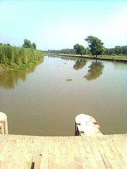 View of a canal in the lower Bari Doab of the Punjab Doabs | |
| Country | Pakistan and India |
Doab (from Persian dō, "two" + āb, "water" or "river") is a term used in India and Pakistan for the "tongue,"[1] or water-rich[2] tract of land lying between two converging, or confluent, rivers. It is similar to an interfluve.[3] In the Oxford Hindi-English Dictionary, R. S. McGregor defines it as "a region lying between and reaching to the confluence of two rivers (esp. that between the Ganges and Yamuna)."[4]
Khadir, bangar, barani, nali and bagar
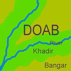
Since North India and Pakistan are coursed by a multiplicity of Himalayan rivers that divide the plains into doabs (i.e. regions between two rivers), the Indo-Gangetic plains consist of alternating regions of river, khadir and bangar. The regions of the doabs near the rivers consist of low-lying, floodplains, but usually very fertile khadir and the higher-lying land away from the rivers consist of bangar, less prone to flooding but also less fertile on average.[5][6]
Khadir is also called Nali or Naili, specially in northern Haryana the fertile prairie tract between the Ghaggar river and the southern limits of the Saraswati channel depression in that gets flooded during the rains.[7]
Within bangar area, the Barani is any low rain area where the rain-fed dry farming is practiced, which nowadays are dependent on the tubewells for irrigation.[8] Bagar tract, an example of barani land, is the dry sandy tract of land on the border of Rajasthan state adjoining the states of Haryana and Punjab.[8] Nahri is any canal-irrigated land,[7] for example, the Rangoi tract which is an area irrigated by the Rangoi channel/canal made for the purpose of carrying flood waters of Ghagghar river to dry areas.[9][10]
Historically, villages in the doabs have been officially classified as khadir, khadir-bangar (i.e. mixed) or bangar for many centuries and different agricultural tax rates applied based on a tiered land-productivity scale.[11][12]
Yamuna-Ganga Doab
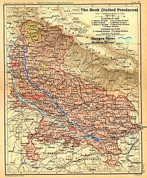
The Yamuna-Ganga Doab or Uttar Pradesh Doab designates the flat alluvial tract between the Ganges and Yamuna rivers extending from the Sivalik Hills to the two rivers' confluence at Allahabad. The region has an area of about 23,360 square miles (60,500 square km); it is approximately 500 miles (805 km) in length and 60 miles (97 km) in width.[13]
The region of the Doab figures prominently in the history and myths of Vedic period. The British raj divided the Doab into three administrative districts, viz., Upper Doab (Meerut), Middle Doab (Agra) and Lower Doab (Allahabad).[13]
Currently the following states and districts form part of the Ganga Doab:[13]
Upper Doab
Uttarakhand: Dehradun and Haridwar
Uttar Pradesh: Saharanpur, Shamli, Muzaffarnagar, Baghpat, Meerut, Ghaziabad, Hapur, Gautam Buddh Nagar and Bulandshahr
Central or Middle Doab
Etah, Kasganj, Aligarh, Agra, Hathras, Firozabad, Farrukhabad, Kannauj, Mainpuri, Etawah, Auraiya and Mathura. Mathura is in the trans-Yamuna region of Braj.
Lower Doab
The Punjab Doabs
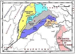
Each of the tracts of land lying between the confluent rivers of the Punjab region of Pakistan and India has a distinct name, said to have been coined by Raja Todar Mal, a minister of the Mughal emperor Akbar. The names (except for 'Sindh Sagar') are a combination of the first letters, in the Persian alphabet, of the names of the rivers that bound the Doab. For example, Jech = 'Je'(Jhelum) + 'Ch'(Chenab). The names are (from west to east):
Sindh Sagar Doab
The Sindh Sagar Doab lies between the Indus and Jhelum rivers.
Jech Doabs
The Jech Doab (also Chaj Doab) (small portion of the Jech Doab is Majha[15]) lies between the Jhelum and the Chenab rivers.
Rechna Doabs
The Rechna Doab (considerable portion of the Rechna Doab is Majha[15]) lies between the Chenab and the Ravi rivers.
Bari Doabs
The Bari Doab (considerable portion of the Bari Doab is Majha[15]) lies between the Ravi and the Beas rivers.
Bist Doab
The Bist Doab (or Doaba) - between the Beas and the Sutlej rivers.
Other Doabs
Malwa Doab
The rivers flowing through the Malwa region, covering current states of Madhya Pradesh and parts of north-eastern Rajasthan, also has doab region such as Upper Malwa doab and Lower Malwa doab.
Raichur Doab
The Raichur Doab is the triangular region of Andhra Pradesh and Karnataka states which lies between the Krishna River and its tributary the Tungabhadra River, named for the town of Raichur.
See also
- Interamnia, an ancient Latin placename, meaning "between rivers"
Notes
- ↑ doab or duab, n., OED Online, Oxford University Press, September 2013, retrieved 11 September 2013
- ↑ August 2010, On The brink: Water governance in the Yamuna river basin in Haryana, Society for Promotion of Wastelands Development, PEACE Institute Charitable Trust, page vi.
- ↑ Doab., Webster's Third New International Dictionary, Unabridged., 2013, retrieved 11 September 2013
- ↑ McGregor 1993, p. 513.
- ↑ Pakistan: Soils, Encyclopædia Britannica, 2010,
... khaddar soils. Away from the river, toward the middle of the doabs, older alluvial soils (called bangar) are widely distributed ...
- ↑ Damage to Yamuna Khadar, Ravi Shankar's Art of Living Responsible: NGT, Khas Khabar. 7 Dec 2017.
- 1 2 "The imperial gazeteers of India, 1908", British Raj, page 288.]
- 1 2 E. Walter Coward, 1980, "Irrigation and Agricultural Development in Asia: Perspectives from the social sciences", Cornell University press, ISBN 0801498716.
- ↑ 1987, "gazetteer of India: Hisar District" Archived 1 May 2014 at the Wayback Machine., page 7.
- ↑ 1987, "Gazeteers of Hisar district, 1987", Government of Haryana, page 162.]
- ↑ F.C. Channing, Land Revenue Settlement of the Gurgaon District, Government of India,
... The rates here applied were the same as those applied in the Bangar and Khadar circles and the same comparisons hold good ...
- ↑ Oswald Wood, R. Maconachie, Final report on the settlement of land revenue in the Delhi District, Government of India, 1882,
... The Khadar-Bangar chak lies along the river; 37 villages are purely Khadar and 39 partly Khadar partly Bangar. The villages nearest the river are subject to inundations, but where the water runs off in time, the natural fertility of the ...
- 1 2 3 Ganges-Yamuna Doab, Encyclopedia Britannica.
- ↑ "Archaeology Of Lower Ganga-Yamuna Doab 2 Volumes".
- 1 2 3 Kakshi, S.R.; Pathak, Rashmi; Pathak, S.R.Bakshi R. (2007-01-01). Punjab Through the Ages. Sarup & Sons. ISBN 978-81-7625-738-1. Retrieved 12 June 2010.
References
- McGregor, Ronald Stuart (1993), The Oxford Hindi-English Dictionary, Oxford University Press, p. 513, ISBN 978-0-19-864339-5, retrieved 11 September 2013