Alwar
| Alwar Ulwar | |
|---|---|
| City | |
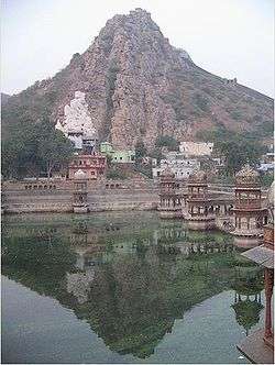 Scenic landscape of Alwar | |
| Nickname(s): Tiger Gate of Rajasthan | |
 Alwar | |
| Coordinates: 27°32′59″N 76°38′08″E / 27.549780°N 76.635539°ECoordinates: 27°32′59″N 76°38′08″E / 27.549780°N 76.635539°E | |
| Country | India |
| State | Rajasthan |
| District | Alwar |
| Elevation | 268 m (879 ft) |
| Population (2011) | |
| • City | 315,310 |
| • Rank | 8th in Rajasthan |
| • Metro | 341,422 |
| Languages | |
| • Official | Hindi |
| • Regional | Rajasthani}} |
| Time zone | UTC+5:30 (IST) |
| PIN | 301001 |
| ISO 3166 code | RJ-IN |
| Vehicle registration | RJ-02 |
| Website | http://alwar.rajasthan.gov.in/ |
Alwar (formerly Ulwar), located 150 km south of Delhi and 150 km north of Jaipur, is a city in India's National Capital Region and the administrative headquarters of Alwar District in the state of Rajasthan. Alwar is a hub of tourism with several forts, lakes, heritage havelis and nature reserves, including the Bhangarh Fort, the Sariska Tiger Reserve and Siliserh lake.
History
Early history
Alwar was a part of the Matsya Kingdom, one of the sixteen ancient Mahājanapadas.[1]
Medieval
The history of Alwar dates back to 1000 CE. The king of Amer (the former seat of Jaipur state) ruled the area in the eleventh century and his territory extended up to the present-day city of Alwar. He founded the city of Alpur in 1106 Vikrami samvat (1049 CE) under his own name, which eventually became Alwar.[2] From time to time, a different Rajput sub-clan came to rule Alwar. Examples included the Khanzada Rajputs, the Nikumbh Rajputs, the Badgujjar Rajputs, and finally the Naruka (Kachwaha) Rajputs who took the control over this area. Bhadanakas (Bhadana) clan of Gurjar, The Maratha Empire and Jats of Bharatpur State also ruled this region for a short period. A Rajput, Partap Singh, took the Alwar Fort from the Jat Raja of Bharatpur and laid down the foundation for modern day Alwar.
The Hindu King Hemchandra Vikramaditya (Hemu), born into a Brahmin family in Machari, a village in Alwar, was a Hindu emperor of North India during the 16th century. This was a period when the Mughals and Afghans were vying for power in the region. Hemu acceded to the throne of Delhi on 7 October 1556 after defeating Akbar's Mughal forces in the Battle of Delhi in the Tughlakabad area in Delhi, and became the de facto king. He won twenty-two battles in succession and became the last Hindu emperor of India.
Colonial era
Alwar State, a princely state established in 1770, was established by a Kachwaha Rajput named Pratap Singh who was earlier a jagirdar of "Dhai Gaon" (two-and-a-half villages) near Machari. His successor "Bakhtawar Singh Kachwaha" was defeated after launching an armed incursion into neighbouring Jaipur State (ruled by their Kachwaha seniors, erstwhile overlords of his predecessor) and being forced to accept the consequent treaty mediated by East India Company prohibiting him from political relations with other states without the consent of the colonial British.[3] According to the "Gazetteer of Ulwar" published by the British raj, Alwar State was subdivided into four regions:
- Rath region: current Behror and Neemrana, was ruled by Lah Chauhan rajput zamindar who had descended from Prithviraj Chauhan.[4] Sahesh Mal was a son of Raja Sangat Singh Chauhan. Sangat was the great grandson of Chahir Deo Chauhan, brother of famous rajput king Prithviraj Chauhan.[5] In accordance with the pledge by the raja Sangat Singh Chauhan to his younger queen for marrying her in his old age, her two sons from him were bestowed the Rath area and its headquarter of Mandhan near Neemrana.[4] King Sangat Singh Chauhan's 19 sons from the older queen set out to seek their fortunes.[4] Of the 19 brothers, Harsh Dev Chauhan and Sahesh Mal Chauhan arrived in the Gurgaon district.[4] Lah Chauhan, the ruler of Rath, was a son of raja Sangat Singh Chauhan by the younger Rani whose two sons became inheritors of Raja Sangat Singh’s territory of Rath with its headquarter at Mandhan when other 19 sons from the other wives were required to quit the kingdom as per the promise of Raja Sangat.[4][6][7][8]
- Wai region: current Bansur and Thana Ghazi, was ruled by Shekhawat rajput zamindars.
- Narukhand region: current Rajgarh and Laxmangarh, was ruled by Naruka sub-branch of Kachwaha rajputs who were from the same branch as the ruling kings of the Alwar State
- Mewat region: current Palwal and Nuh districts, had the highest population of the Meo Muslims.
Post-independence
Alwar acceded to the dominion of India following the independence of India in 1947. On 18 March 1948, the state merged with three neighbouring princely states (Bharatpur, Dholpur and Karauli) to form the Matsya Union. On 15 May 1949, it was united with neighbouring princely states and the territory of Ajmer to form the present-day Indian state of Rajasthan. Alwar was designated as part of the National Capital Region, resulting in additional development projects including rapid-rail to Delhi and drinking water improvements.[9] The military cantonment of Itarana lies on the outskirts of Alwar.
Tourist attractions
Alwar is the first major city when travelling from Delhi to Rajasthan. The city's heritage, apart from being a draw for tourists, has been an attraction for Bollywood film shoots including Shakespeare Wallah, Maharaja (1998), Karan Arjun at Sariska palace and dadigarh fort and Bhangarh, Saajan Chale Sasural at Sariska palace, Talaash: The Hunt Begins... and Trip to Bhangarh. The Mega Alwar trade fair is held at Dusshera ground every year. Alwar is also known for its hand-made Papier-mâché.
Fairy Queen
The Fairy Queen, a national treasure (cultural artifact) of India and the world's oldest working locomotive engine (c. 1855 CE),[10] operates as a tourist luxury train between Delhi and Alwar.
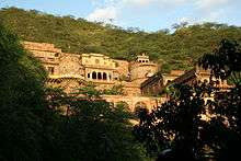
Bala Qila
Bala Qila (lit. "Young Fort"), also known as Alwar Fort, is a fort approximately 300 meters above the city, founded by the 15th-century Khanzada Rajput ruler Hasan Khan Mewati and built on the foundations of a 10th-century mud fort.[11] Situated on the Aravalli Range, the fort is 5 kilometers long and about 1.5 kilometers wide with turrets, a large gate, a temple, and a residential area.[12]
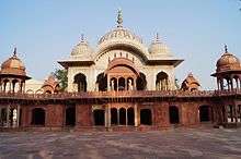
City Palace
The City Palace, also known as Vinay Vilas Mahal, built in 1793 CE by Raja Bakhtawar Singh, blends the Rajputana and Islamic architectural styles and has marble pavilions on lotus-shaped bases in its courtyard. The palace houses a state museum with a collection of manuscripts, including one depicting Emperor Babur’s life, Ragamala paintings and miniatures, and historic swords that once belonged to Muhammad Ghori, Emperor Akbar and Aurangzeb; and a golden Durbar hall. This palace that once belonged to the Maharaja (lit. Great Ruler) has now been converted into a District Administrative office also housing the District Court.[13]
Moosi Maharani ki Chhatri
This cenotaph was built by Vinay Singh in the memory of King Bakhtawar Singh and his queen, Moosi, in 1815.
Sariska Tiger Reserve
The Sariska Tiger Reserve, a National Park and Tiger Reserve, is located in the Aravali hills only a few kilometers away from Alwar. Declared a Wildlife reserve in 1955 and a National Park in 1982, it is the first reserve in the world to have successfully relocated tigers. The sanctuary, which became a part of India's Project Tiger in 1978, also preserves other species including rare birds and plants.[14]
Bhangarh Fort
Bhangarh Fort, branded as the fourth most haunted palace in the world, and the most haunted palace in Asia, is a 17th-century fort built by Man Singh I (one of the NavRatnas of Akbar's court) for his younger brother Madho Singh I. The fort, a monument protected by the Archaeological Survey of India and is known for its association to legends and paranormal activities,[15] is a tourist attraction for visitors across the world.[16]
Ashoka's Buddhist stupa
Nearby Viratnagar there is a Buddhist stupa and an inscription from the Mauryan emperor Ashoka. According to legends, Pandavas spent some time in their ignorance here. There are a large number of religious devotees on the Pandupole-Bharthari Loktirtha. Alwar contains a number of historical monuments, such as 'Deewan ji ki lal haweli', which was built in 1754 and owned by Rajendra Kumar jain.

Hill Fort Kesroli
Hill Fort Kesroli, a 14th-century fort, has now been converted into and is conserved as a heritage hotel.[17]
Bharthari Temple
Bharthari temple is dedicated to the king of Ujjain, who became a saint and is now commonly known as Baba Bharthari. He is sometimes identified with Bhartṛhari, a 7th-century poet. He is revered and prayed to, the temple is visited by the local population, and a fair is also organised each year known as 'Bharthari Baba ka Mela'.
Transport
The nearest airports are Indira Gandhi International Airport in Delhi (143 km away), Jaipur International Airport (150 km away), and an airport currently under development in Bhiwadi airport (90 km away). Alwar railway station, on the Delhi–Jaipur line, is connected with Delhi, Jaipur, and Mumbai. Alwar is connected by roads from major cities of Rajasthan and nearby states.
Geography and climate
Alwar is located at 27°34′N 76°36′E / 27.57°N 76.6°E. It has an average elevation of 271 m (889 ft). The Ruparail River is a major river near the city. Alwar is fairly rich in mineral wealth; it produces marble, granite, feldspar, dolomite, quartz, lime stone, soap stone, barites, copper clay, copper ore and pyrophylite.[18]
Demographics
| Population Growth of Alwar City | |||
|---|---|---|---|
| Census | Pop. | %± | |
| 1891 | 52,400 | — | |
| 1901 | 56,700 | 8.2% | |
| 1911 | 41,300 | -27.2% | |
| 1921 | 44,800 | 8.5% | |
| 1941 | 54,100 | — | |
| 1951 | 57,900 | 7.0% | |
| 1961 | 72,700 | 25.6% | |
| 1971 | 100,800 | 38.7% | |
| 1981 | 140,000 | 38.9% | |
| 1991 | 210,100 | 50.1% | |
| 2001 | 266,203 | 26.7% | |
| 2011 | 341,422 | 28.3% | |
| source:[19] | |||
At the time of the 2011 census, the population of Alwar city and Alwar district were 341,422 and 1,015,310 respectively, with Hindus representing 90.7% of the population, Muslims representing 4.3%, Sikhs representing 2.6%, Jains representing 2.1%, and the remaining 1.3% belonging to other religions.[20][21] The main castes are the Yadav/Ahir caste, accounting for 39% of the population and concentrated in northern and central areas; Rajputs, accounting for 10% of the population and found mainly in southern areas; and Jats accounting for 5% of the population and found mainly in the eastern parts of the district. Among Hindus, there are also Meenas, Gujjars and Vaish. Alwar's Muslims are mostly Meos.
Education
Raj Rishi Bhartrihari Matsya University was established in 2012-13. Alwar has several schools such as Kendriya Vidyalaya, Army Public School and Alwar Public School and colleges (Raj Rishi college, Siddhi Vinayak College, Presidency College, Government Law College). The Employee's State Insurance Corporation (ESIC) Medical College is constructed with a whooping INR 800 crore budget and started operating from 2017.[22]
Notable people
Notable people from Alwar include the actress Sakshi Tanwar, the entrepreneur Rahul Yadav, and the military commander Pran Sukh Yadav (1802–1888).
References
- ↑ "History of Alwar, Origin of Alwar, Alwar History In Rajasthan India". Indiasite.com. Archived from the original on 27 June 2012. Retrieved 7 March 2013.
- ↑ "Welcome to Alwar, The Gateway of Rajastan > History Of District Alwar". Alwar.nic.in. Archived from the original on 20 June 2014. Retrieved 19 November 2014.
- ↑

- 1 2 3 4 5 Henry Miers Elliot and John Beames, Memoirs on the History, Folk-lore, and Distribution of the Races, Volume 1.
- ↑ Henry Miers Elliot and John Beames, 1869, Memoirs on the history, folk-lore, and distribution of the races of the North Western Provinces of India: being an amplified edition of the original supplemental glossary of Indian terms. Trübner & co. p.64 and 82.
- ↑ Henry Miers Elliot, Supplemental Glossary of Terms Used in the North Western Provinces
- ↑ Henry Miers Elliot, Supplement to the Glossary of Indian Terms, A.-J
- ↑ Panjab Notes and Queries, Volume 1
- ↑ "Bharatpur becomes NCR; Delhi Metro to chug into Alwar soon". daily.bhaskar.com. Archived from the original on 29 November 2014. Retrieved 19 November 2014.
- ↑ World’s oldest engine gathers fresh steam, The Times of India, 12 February 2017, archived from the original on 5 June 2017
- ↑ "Alwar Tourism: Places to Visit in Alwar - Rajasthan Tourism". tourism.rajasthan.gov.in. Archived from the original on 11 December 2017. Retrieved 10 December 2017.
- ↑ Iyengar, Abha (4 May 2017). "Delhi to Alwar: Among the ruins". livemint.com/. Archived from the original on 10 December 2017. Retrieved 10 December 2017.
- ↑ Safvi, Rana (28 May 2017). "In a state of neglect". The Hindu. ISSN 0971-751X. Archived from the original on 30 April 2018. Retrieved 10 December 2017.
- ↑ "Sariska National Park - complete detail - updated". natureconservation.in. Archived from the original on 10 December 2017. Retrieved 10 December 2017.
- ↑ Safvi, Rana (12 November 2017). "Bhangarh: the most haunted fort in India". The Hindu. ISSN 0971-751X. Archived from the original on 30 April 2018. Retrieved 10 December 2017.
- ↑ "The Times of India: Latest News India, World & Business News, Cricket & Sports, Bollywood". The Times of India. Retrieved 19 November 2014.
- ↑ "Ruins revisited". The Hindu. July 29, 2004.
- ↑ "Welcome to Alwar, The Gateway of Rajastan > Mineral Resources". Alwar.nic.in. Archived from the original on 19 June 2014. Retrieved 19 November 2014.
- ↑ "Historical Census of India". Populstat.info. Archived from the original on 17 February 2013. Retrieved 19 November 2014.
- ↑ "Alwar District Population Census 2011, Rajasthan literacy sex ratio and density". census2011.co.in. Archived from the original on 16 February 2013. Retrieved 6 April 2013.
- ↑ "Archived copy". Archived from the original on 4 November 2016. Retrieved 30 July 2016. Alwar City Population Census 2011
- ↑ "अलवर को इसी वर्ष मिलेगा मेडिकल कॉलेज, 2017 में होंगे प्रवेश". Patrika.
Bibliography
- Powlett, P. W. (1838). Gazetteer of Ulwur (Alwar). Archive.org. Retrieved 19 November 2014.
External links
| Wikimedia Commons has media related to Alwar. |
| Wikivoyage has a travel guide for Alwar. |
| Outline |  | ||||||||||||||
|---|---|---|---|---|---|---|---|---|---|---|---|---|---|---|---|
| Governance | |||||||||||||||
| Divisions and districts |
| ||||||||||||||
| Major cities | |||||||||||||||
| Related templates |
| ||||||||||||||
| Authority control |
|---|