Nainital
| Nainital | |
|---|---|
| Town | |
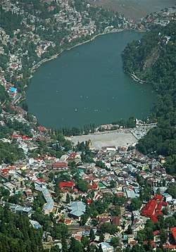 View of Nainital Lake City | |
| Nickname(s): Sarovar Nagari (Lake city) | |
 Nainital Location in Uttarakhand, India  Nainital Nainital (India) | |
| Coordinates: 29°23′42″N 79°26′56″E / 29.395°N 79.449°ECoordinates: 29°23′42″N 79°26′56″E / 29.395°N 79.449°E | |
| Country | India |
| State | Uttarakhand |
| District | Nainital |
| Elevation | 2,084 m (6,837 ft) |
| Population (2011) | |
| • Total | 41,377 |
| Languages | |
| • Official | Hindi, Sanskrit |
| • Other | Kumaoni |
| Time zone | UTC+5:30 (IST) |
| PIN | 263001/263002 |
| Telephone code | +91 - 5942 |
| Vehicle registration | UK-04 |
| Website |
nainital |
Nainital ![]()
Geography and climate
Nainital is located at 29°23′N 79°27′E / 29.38°N 79.45°E.[2] The slopes of the nearby mountains are most populated, with an elevation ranging from 1,940–2,100 m (6,360–6,890 ft). The highest point nearby is Naina Peak or China Peak, with an elevation of 2,619 m (8,593 ft).
Nainital experiences subtropical highland climate (Cwb) according to Köppen–Geiger climate classification system as the city's climate is influenced by the elevation. The city is a bit dry during winter and very wet during summer due to South Asian monsoon system. The lowest precipitation total occurs in November with total 7.9 millimetres (0.31 in), while the highest precipitation total occurs in July with total 725 millimetres (28.5 in). Like most places in temperate region, Nainital has relative cool summer. The hottest month is July with temperature ranging from 16.4 °C (61.5 °F) to 23.5 °C (74.3 °F), while the coldest month is January with temperature ranging from 1.7 °C (35.1 °F) to 10.7 °C (51.3 °F).
Nainital is said to be one the best shining diamonds of Himalayan Belt. This city has 3 major lakes that contribute to make it cool and calm throughout the year.
| Climate data for Nainital (1953-1979) | |||||||||||||
|---|---|---|---|---|---|---|---|---|---|---|---|---|---|
| Month | Jan | Feb | Mar | Apr | May | Jun | Jul | Aug | Sep | Oct | Nov | Dec | Year |
| Average high °C (°F) | 10.7 (51.3) |
12.3 (54.1) |
16.3 (61.3) |
20.8 (69.4) |
23.5 (74.3) |
23.5 (74.3) |
21.6 (70.9) |
21.0 (69.8) |
20.7 (69.3) |
18.7 (65.7) |
15.4 (59.7) |
12.9 (55.2) |
18.1 (64.6) |
| Average low °C (°F) | 1.7 (35.1) |
3.5 (38.3) |
7.5 (45.5) |
11.9 (53.4) |
14.6 (58.3) |
16.4 (61.5) |
16.5 (61.7) |
16.0 (60.8) |
14.1 (57.4) |
9.7 (49.5) |
5.7 (42.3) |
3.1 (37.6) |
10.1 (50.2) |
| Average precipitation mm (inches) | 80.3 (3.161) |
60.4 (2.378) |
55.7 (2.193) |
33.7 (1.327) |
73.8 (2.906) |
327.5 (12.894) |
725.0 (28.543) |
553.4 (21.787) |
385.0 (15.157) |
135.4 (5.331) |
7.9 (0.311) |
27.6 (1.087) |
2,465.7 (97.075) |
| Source: India Meteorological Department[3] | |||||||||||||
Demographics
As of the 2011 Indian census, Nainital had a population of 41,377.[4] Males constitute 52.3% of the population and females 47.7%. In 2011, Nainital had an average literacy rate of 92.93%, higher than the Uttarakhand state average of 78.82%.[4] In Nainital, 9.54% of the population is under 6 years of age. Kumaoni people form the major part of the town's population along with people from all over India.
Mythology
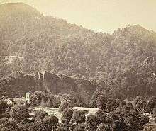
It is believed that the Naini Lake is one of the 51 Shakti Peeths, or The most popular is based on the story of the death of the goddess Sati. Out of grief and sorrow, Shiva carried Sati's body, reminiscing about their moments as a couple, and roamed around the universe with it. Vishnu had cut her body into 52 body parts, using his Sudarshana Chakra, which fell on Earth to become sacred sites where all the people can pay homage to the Goddess. The spot where Sati's eyes (or Nain) fell, came to be called Nain-tal or lake of the eye. The goddess Shakti is worshiped at the Naina Devi Temple, known by locals as Naini Mata Temple on the north shore of the present day lake.[5]
History
Early construction
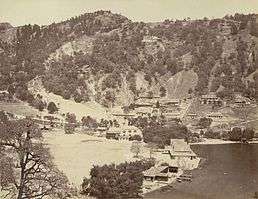
The Kumaon Hills came under British rule after the Anglo-Nepalese War (1814–16). The hill station town of Naini Tal was founded only in 1841, with the construction of the first European house (Pilgrim Lodge) by P. Barron, a sugar trader from Shahjahanpur. In his memoir, he wrote: "It is by far the best site I have witnessed in the course of a 1,500 miles (2,400 km) trek in the Himalayas."[6] In 1846, when a Captain Madden of the Bengal Artillery visited Naini Tal, he recorded that "houses were rapidly springing up in most parts of the settlement: some towards the crest of the military ranges were nearly 7,500 ft (2,300 m) above sea level: the rugged and woody Anyarpatta Aashish (Anyar-patt – in Kumaoni means – complete blackout. The reason for this nomenclature by the locals was because there were minimal sun rays due to its location and dense forests) was being gradually planted and that the favourite sites were on the undulating tract of forest land which stretched back from the head of the lake to the base of China and Deopatta (Camel's Hump). The church, St. John(1846) in the Wilderness, was one of the earliest buildings in Nainital, followed by Belvedere, Alma lodge, Ashdale Cottage(1860)..."[7] Soon, the town became a health resort favoured by British soldiers and by colonial officials and their families trying to escape the heat of the plains. Later, the town became the summer residence of the governor of the United Provinces.
The landslip of 1880
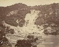
In September 1880 a landslide ('the landslip of 1880') occurred at the north end of the town, burying 151 people. The first known landslide had occurred in 1866, and in 1879 there was a larger one at the same spot, Alma Hill, but "the great slip occurred in the following year, on Saturday 18 September 1880."[7]
"Two days preceding the slip there was heavy rain, ... 20 inches (510 mm) to 35 in (890 mm) fell during the 40 hours ending on Saturday morning, and the downpour still lasted and continued for hours after the slip. This heavy fall naturally brought down streams of water from the hill side, some endangering the Victoria Hotel, ... (which) was not the only building threatened ... Bell's shop, the Volunteer Orderly Room and the Hindu (Naina Devi) temple were scenes of labour with a view to diverting streams. At a quarter to two the landslip occurred burying those in and around the buildings mentioned above."[7]
The number of dead and missing were 108 Indian and 43 British nationals. (See poem by Hannah Battersby on the page Literary references to Nainital.) The Assembly Rooms and the Naina Devi Temple were destroyed in the disaster. A recreation area known as 'The Flats' was later built on the site and a new temple was erected. To prevent further disasters, storm water drains were constructed and building bylaws were made stricter.
.jpg)
In the latter half of the 19th century a number of "European" schools for boys and girls were founded in Nainital. During the Victorian and Edwardian eras, students in these schools consisted largely of children of the British colonial officials or soldiers. The Diocesan Girls' High School, now known as All Saints' College, was established in 1869, near where the High Court of Uttarakhand stands today. By 1906, there were over half a dozen such schools,[7] including the Diocesan Boys' School (later renamed Sherwood College) and the Philander Smith's college (later renamed Halett War School, currently Birla Vidya Mandir).
St. Joseph's College, Nainital (popularly known as SEM), a day-boarding and residential school built by Irish brothers in 1888, celebrated its 125th anniversary in 2013. Another important school for girls, St. Mary's Convent High School, Nainital(popularly known as Ramnee), was established in 1878, and celebrated its 125th anniversary in year 2003.
Famous Landmarks[8]
A popular hill station, Nainital has numerous tourist spots:
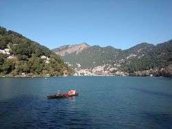
- Nainital Lake
- Naini Peak
- Tiffin Top
- Snowview Point
- Gurney House
- Gurdwara Singh Sabha
- Naina Devi Temple
- Cave Garden
- Sat Tal
- Hanumangarhi
- Mall Road
- Pt. G.B. Pant High Altitude Zoo, Nainital
- Himalaya Darshan
- Himalaya Darshan Eco Zone
- St. John’s Church
- Kilbury
- Thandi Road
- Tibetan Market [9]
Libraries
There are a number of libraries in the Nainital1 area. Among them are the Durga Lal Shah Municipal Public Library on the Mall, founded in 1934,[10] the Uttarakhand Academy of Administration, Library and Documentation Center, Mallital,[11] the ARIES Observatory Library,[12] and the Kumaon University Library, Nainital.[13]
Notable people
- Billy Arjan Singh, Tiger Conservationist of India, Educated in Nainital.[14]
- Amitabh Bachchan, Bollywood actor. Educated at Sherwood College.
- Kabir Bedi, Bollywood Actor. Educated at Sherwood College.
- Jim Corbett, hunter of man-eating tigers, author, conservationist and namesake of Jim Corbett National Park. Educated at St. Joseph's College.
- Danny Denzongpa, Bollywood actor studied in Birla Vidya Mandir
- Percy Hobart, British major general and military engineer
- Elsie Inglis, physician and social reformer
- Hastings Ismay, 1st Baron Ismay, first secretary general of NATO
- Anup Jalota, singer
- Sukirti Kandpal, TV actress
- Sudhir Kakar, renowned psychoanalyst
- Sam Manekshaw, Indian Army Chief of Staff during Indo-Pakistani War of 1971. Educated at Sherwood College.
- Eric Maturin, British actor
- Lalit Modi, Indian Premier League (IPL) chairman. Educated at St. Joseph's College.
- Rajendra K. Pachauri, chairman of the Intergovernmental Panel on Climate Change
- Manish Pandey, cricketer who plays for Karnataka and Bangalore
- Nirmal Pandey, Bollywood actor and singer
- Govind Ballabh Pant, statesman and leader of India's independence movement, first Indian Premier of British India, the first Chief Minister of Uttar Pradesh and the third Home Minister of India
- Krishna Chandra Pant, former Deputy Chairman of the Planning Commission of India. Educated at St. Joseph's College.
- Naseeruddin Shah, Bollywood actor. Educated at St. Joseph's College.
- Som Nath Sharma, India's first Param Vir Chakra award winner. Educated at Sherwood College.
- Shivani, Hindi poet
- Dilip Tahil, Bollywood actor. Educated at Sherwood College.
- Narayan Dutt Tiwari, Indian leader and politician, former Governor of Andhra Pradesh, former Chief Minister of Uttarakhand and Uttar Pradesh, and former Finance Minister of India.
- Orde Charles Wingate, British general and commander of the Chindits in Burma during World War II
Gallery
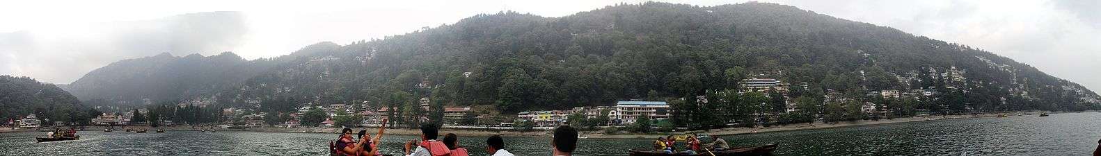 Panoramic view of Nainital from Naini Lake
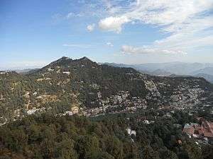 Nainital overview
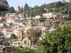 Urban Areas
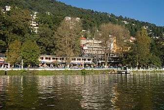 The Mall Road, 2006.
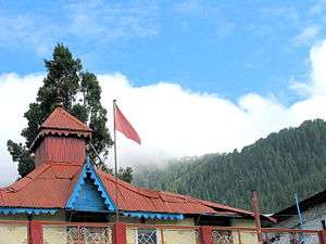 Ramlila Bhawan, Mallital, Nainital.
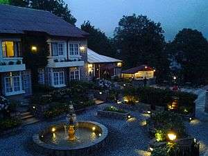 A view from Hotel Naini Retreat's Balcony.
.jpg) Naini Lake after snowfall (2007)
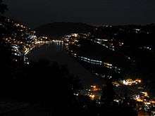
Naini Lake after snowfall (2007) Nainital lake in the morning
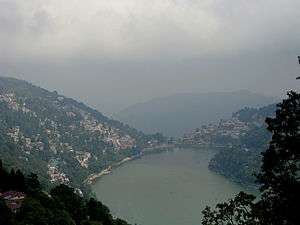 Nainital in May 2011
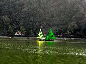 Yachts in Naini Lake in March 2011
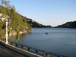 Nainital Lake in 2009.
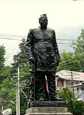 Statue of Govind Ballabh Pant, at Mall Road, Nainital.
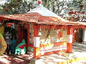 Golu Devta temple, at Ghorakhal near Nainital.
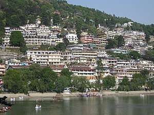 Naini Lake
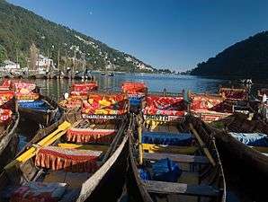 Boats on the Lake.
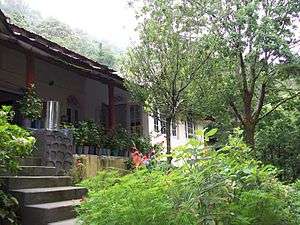 Gurney House-the home of Jim Corbett
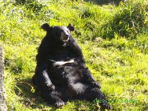 A Bear in the Pt. G B Pant High Altitude Zoo, Nainital.
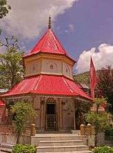 Naina Devi Temple, after which the place gets its name.
See also
- St. Joseph's College, Nainital
- Literary references to Nainital
- Aryabhatta Research Institute of Observational Sciences
- The Hive Cottage Nainital childhood residence of Jim Corbett
Notes and references
- ↑ Nainital District, The Imperial Gazetteer of India, volume 18, pp. 322–323. 1908
- ↑ Falling Rain Genomics, Inc – Nainital. Fallingrain.com.
- ↑ "Monthly mean maximum & minimum temperature and total rainfall based upon 1901-2000 data". India Meteorological Department. Retrieved 4 February 2017.
- 1 2 Nainital Population Census 2011.
- ↑ View of Mallital, without the presend Naina Devi Temple (1865) British Library.
- ↑ (Pilgrim 1844)
- 1 2 3 4 (Murphy 1906)
- ↑ "Places to See in Nainital". TripAdvisor.
- ↑ "15 Points of Attraction In The Queen Of Lakes – Nainital". HillTaxi.com.
- ↑ Singh, Sarina (2005). Lonely Planet: India (Nainital). ISBN 1-74059-694-3. Page 425.
- ↑ The World Bank India: Depository Libraries, 2006.
- ↑ Astronomical Networking Libraries Archived 17 July 2006 at the Wayback Machine.
- ↑ "Kumaon University".
- ↑ https://sikhchic.com/people/_billy_arjan_singh_honorary_tiger
- Bateman, Josiah (1860), The Life of The Right Rev. Daniel Wilson, D.D., Late Lord Bishop of Calcutta and Metropolitan of India, Volume II, John Murray, Albemarle Street, London.
- Corbett, SAYUJ (2002) [2000], Inter H.G.S – Indian Culture in Daily Life., Oxford India Reprint
- Corbett, Jim (2002) [1948], The Man Eating Leopard of Rudraprayag, Oxford India Reprint
- Corbett, Jim (2002) [1954], The Temple Tigers and More Man-Eaters of Kumaon, Oxford India Reprint
- Fayrer, Joseph (1900), Recollections of my life, William Blackwood and Sons, Edinburgh and London
- Imperial Gazetteer of India, Volume 18, pp. 322–323., Oxford University Press, Oxford and London, 1908
- Kennedy, Dane (1996), The Magic Mountains: Hill Stations and the British Raj, University of California Press, Berkeley, Los Angeles, and Oxford. 264 pages.
- Kipling, Rudyard (1889), The Story of the Gadsbys, Macmillan and Company, London
- Kipling, Rudyard (1895), Under the Deodars, Macmillan and Company, London
- McLaren, Eva Shaw (1920), Elsie Inglis: The Woman with the Torch, Macmillan and Company, New York
- M'Crindle, J.W. (1901), Ancient India: As Described in Classical Literature, Archibald ConstaHble & Company, Westminster
- Murphy, C.W. (1906), A Guide to Naini Tal and Kumaun, Allahbad, United Provinces
- Notes on Wanderings in the Himmala, containing descriptions of some of the grandest scenery of the snowy range, among others of Naini Tal, Agra Akhbaar Press, Agra
External links
| Wikimedia Commons has media related to Nainital. |
| Wikisource has the text of the 1911 Encyclopædia Britannica article Naini Tal. |
