Darbhanga
| Darbhanga | |
|---|---|
| Municipal Corporation | |
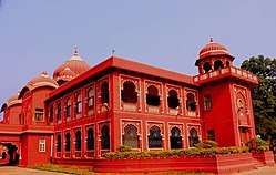 Lalit Narayan Mithila University at Darbhanga | |
 Darbhanga Location in Bihar, India | |
| Coordinates: 26°10′N 85°54′E / 26.17°N 85.9°ECoordinates: 26°10′N 85°54′E / 26.17°N 85.9°E | |
| Country | India |
| State | Bihar |
| Region | Mithila |
| District | Darbhanga |
| Elevation | 52 m (171 ft) |
| Population (2011) | |
| • Total | 267,348 |
| Languages | |
| • Official | Maithili, Hindi |
| Time zone | UTC+5:30 (IST) |
| PIN | 8460xx |
| Telephone code | 06272 |
| ISO 3166 code | IN-BR |
| Vehicle registration | BR-07 |
| Sex ratio | 910:1000 ♂/♀ |
| Lok Sabha constituency | Darbhanga |
| Vidhan Sabha constituency | Darbhanga, Darbhanga Rural |
| Website |
darbhanga |
Darbhanga is a Municipal Corporation in the Indian state of Bihar. It is the headquarters of Darbhanga district and Darbhanga division and was the seat of the Raj Darbhanga and capital of the Mithila region.
History
Demographics
The 2011 Census of India recorded Darbhanga as a municipal corporation with its population of 267,348 comprising 142,377 males and 124,971 females.[1]
Climate
Darbhanga has a humid subtropical climate (Köppen climate classification Cwa).
| Climate data for Darbhanga | |||||||||||||
|---|---|---|---|---|---|---|---|---|---|---|---|---|---|
| Month | Jan | Feb | Mar | Apr | May | Jun | Jul | Aug | Sep | Oct | Nov | Dec | Year |
| Record high °C (°F) | 30.4 (86.7) |
33.9 (93) |
39.9 (103.8) |
42.0 (107.6) |
41.9 (107.4) |
43.4 (110.1) |
39.1 (102.4) |
38.4 (101.1) |
39.6 (103.3) |
39.2 (102.6) |
33.9 (93) |
29.9 (85.8) |
43.4 (110.1) |
| Average high °C (°F) | 22.1 (71.8) |
25.8 (78.4) |
31.0 (87.8) |
34.1 (93.4) |
35.0 (95) |
34.9 (94.8) |
32.5 (90.5) |
32.8 (91) |
32.5 (90.5) |
31.6 (88.9) |
28.0 (82.4) |
24.8 (76.6) |
30.68 (87.22) |
| Average low °C (°F) | 9.2 (48.6) |
11.0 (51.8) |
15.1 (59.2) |
19.1 (66.4) |
21.2 (70.2) |
22.9 (73.2) |
23.8 (74.8) |
24.2 (75.6) |
23.8 (74.8) |
21.2 (70.2) |
15.8 (60.4) |
10.6 (51.1) |
18.18 (64.72) |
| Record low °C (°F) | −0.2 (31.6) |
−0.2 (31.6) |
3.9 (39) |
9.2 (48.6) |
10.4 (50.7) |
15.9 (60.6) |
18.7 (65.7) |
19.4 (66.9) |
18.9 (66) |
12.7 (54.9) |
7.2 (45) |
2.4 (36.3) |
−0.2 (31.6) |
| Average precipitation mm (inches) | 13.0 (0.512) |
14.0 (0.551) |
9.0 (0.354) |
29.0 (1.142) |
76.0 (2.992) |
139.0 (5.472) |
353.0 (13.898) |
254.0 (10) |
193.0 (7.598) |
73.0 (2.874) |
6.0 (0.236) |
7.0 (0.276) |
1,166 (45.905) |
| Average rainy days | 1.6 | 1.7 | 1.6 | 2.6 | 4.6 | 7.6 | 16.4 | 12.2 | 10.5 | 3.4 | 0.5 | 1.0 | 63.7 |
| Average relative humidity (%) | 68 | 63 | 49 | 56 | 60 | 70 | 78 | 79 | 79 | 73 | 66 | 67 | 67 |
| Source: NOAA (1971–1990)[2] | |||||||||||||
Geography
Darbhanga is located in the northern part of Bihar.
Places adjacent to Darbhanga | ||||||||||
|---|---|---|---|---|---|---|---|---|---|---|
| ||||||||||
Transport
Railways
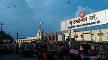
Darbhanga Junction lies on the East Central Railway. It is connected directly to all the major cities of India.
Of the beginning of railway in Darbhanga and its neighbouring areas, The Imperial Gazetteer of India noted:
The famine of 1874 gave a great impetus to the construction of railways, and the District is on the whole well off in the matter of communications. Its south-west corner is traversed for 29 miles by the main line of the Bengal and North-Western Railway, and also by 25 miles of the new chord-line from Hajipur to Bachwara, which runs parallel to the Ganges embankment from east to west. From Samastipur a line runs to Darbhanga town and there branches off in two directions, the first north-west to Sitamarhi through Kamtaul and Jogiara, and the other due east to Khanwa Ghat on the Kosi (Old streem) near Pratapganj. The total length of the line within the District is 146 miles. Most of the earthwork for a line from Sakri to Jaynagar on the Nepal frontier was completed as a relief work during the famine of 1897 ; and the line, which has now been opened, should tap a large grain supply from Nepal.[3]
Darbhanga Junction connects a large part of North Bihar and the Terai of Nepal with the rest of India as it serves as a major railhead. It is the main station of Darbhanga and the district of Madhubani.
Roadways
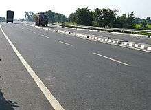
Darbhanga is connected to other parts of India by National Highway 27, National Highway 527B and Bihar State highways 50, 56, 88 and 75. Darbhanga is also connected to Madhubani and Sitamarhi.
The East-West Corridor expressway, which connects Porbandar in Gujarat to Silchar in Assam, passes through Darbhanga.
Public transport
For local transport, the commuters have the options of buses operated by BSRTC and auto-rickshaw. There is a bus stand and a new interstate bus stand is under construction. Bus services are available from Darbhanga to all the nearby major cities viz. Patna, Gaya, Kolkata, Purnia, Bhagalpur, Muzaffarpur, Ranchi, Jamshedpur.
Darbhanga Airport
Darbhanga Airport is a military air force base. The runway length is 9,000 feet.
Media and communications
All India Radio has a 20 kW medium-wave radio station in Darbhanga which transmits various programmes of mass interest and covers a part of North Bihar as well as the Terai of Nepal.
Doordarshan has one DD National and one DD News LPT relay transmitters.
Education
Among the educational institutions are:
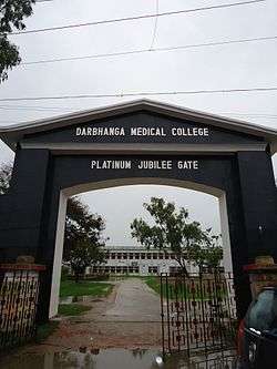
Medical colleges
University
Engineering and technology colleges
Colleges
See also
References
- ↑ "Census of India: View Population Details". www.censusindia.gov.in. Government of India. 2001. Archived from the original on 27 April 2016. Retrieved 14 January 2016.
- ↑ "Zahedan Climate Normals 1971–1990". National Oceanic and Atmospheric Administration. Archived from the original on 23 December 2012. Retrieved 22 December 2012.
- ↑ "Archived copy". Archived from the original on 4 March 2016. Retrieved 14 January 2016.
External links
| Authority control |
|---|
| State symbols | |
|---|---|
| History |
|
| Administration | |
| Overviews | |
| Divisions and districts | |
| Cities | |
| Municipal Corporation |
|
| Poltics | |
| Culture | |