Saharanpur district
| Saharanpur district | |
|---|---|
| District of Uttar Pradesh | |
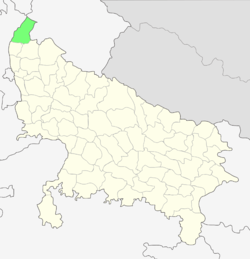 Location of Saharanpur district in Uttar Pradesh | |
| Country | India |
| State | Uttar Pradesh |
| Administrative division | Saharanpur |
| Headquarters | Saharanpur |
| Government | |
| • Lok Sabha constituencies | Saharanpur |
| • Assembly seats | Gangoh and nakud |
| Area | |
| • Total | 3,860 km2 (1,490 sq mi) |
| Population (2011) | |
| • Total | 3,464,228 |
| • Density | 900/km2 (2,300/sq mi) |
| Demographics | |
| • Literacy | 62.61[1] |
| Website | Official website |
Saharanpur district is the northernmost of the districts of Uttar Pradesh state, India. Bordering the states of Haryana, Himachal Pradesh and Uttarakhand, and close to the foothills of Shivalik range, it lies in the northern part of the Doab region. It is primarily an agricultural area.
The district headquarters are Saharanpur city and it belongs to Saharanpur Division. Other principal towns are Behat, Deoband, Gangoh and Rampur Maniharan.
Historical
Medieval period
During the reign of Shamsu’d-Din Iltutmish (1211–36), the region became a part of the Delhi Sultanate. At that time, most of the area remained covered with forests and marshlands, through which the Paondhoi, Dhamola, and Ganda Nala rivers flowed. The climate was humid and malaria outbreaks were common. Muhammad bin Tughluq, the Sultan of Delhi (1325–1351), undertook a campaign in the northern doab to crush the rebellion of the Shivalik kings in 1340, when according to local tradition he learned of the presence of a sufi saint on the banks of the Paondhoi River. After visiting the sage, he ordered that henceforth this region would be known as 'Shah-Haroonpur', after the Sufi Saint Shah Haroon Chishti.[2] The simple but well-preserved tomb of this saint is situated in the oldest quarter of Saharanpur city, between the Mali Gate/Bazar Dinanath and Halwai Hatta. By the end of 14th century, the power of the Sultanate had declined and it was attacked by Emperor Timur (1336–1405) of Central Asia. Timur had marched through Saharanpur region in 1399 to sack Delhi and people of the region fought his army unsuccessfully. A weakened Sultanate was later conquered by the Central Asian Mogul king Babur (1483–1531).
Mughal period
In the 16th century, Babur, a Timurid descendant of Timur and Genghis Khan from Fergana Valley (modern-day Uzbekistan), invaded across the Khyber Pass and founded the Mughal Empire, covering India, along with modern-day Afghanistan, Pakistan and Bangladesh[3] The Mughals were descended from Persianised Central Asian Turks (with significant Mongol admixture).
During the Mughal period, Akbar (1542–1605), Saharanpur became an administrative unit under the Province of Delhi. Akbar bestowed the feudal jagir of Saharanpur to the Mughal treasurer, Sah Ranveer Singh, an Hindu Rohilla who laid the foundations of the present day city on the site of an army cantonment. The nearest settlements at that time were Shekhpura and Malhipur. Saharanpur was a walled city, with four gates: the Sarai Gate, the Mali Gate, the Buria Gate and the Lakhi Gate. The city was divided into the neighbourhoods named Nakhasa Bazar, Shah Behlol, Rani Bazar and Lakhi Gate. The ruins of Shah Ran Veer Singh's old fort can still be seen in the Chaudharian locality of Saharanpur, not far from the better known 'Bada-Imam-bada'. He also built a large Jain temple in Muhallah/Toli Chaundhariyan,[4] it is now known as the 'Digamber-Jain Punchayati Mandir'.
The Sayyids and Rohillas
Mughal emperors Akbar and later Shah Jehan (1592–1666) bestowed the administrative pargana of Sarwat on Muslim Sayyid families. In 1633 one of them founded a city and named it and the surrounding region Muzaffarnagar, in honour of his father, Sayyid Muzaffar Ali Khan. The Sayyids ruled the area until the 1739 invasion by Nadir Shah. After his departure, anarchy prevailed across the entire doab with the region ruled or ravaged in succession by Rajputs, Tyagis, Brahmins, and Jats. Taking advantage of this anarchy, the Rohillas took control of the entire trans-Gangetic region.
Ahmad Shah Durrani, the Afghan ruler who invaded Northwestern and Northern India in the 1750s, conferred the territory of Saharanpur as Jagir on Rohilla chief Najaf Khan, who assumed the title of Nawab Najeeb-ud-Daula and took up residence in Saharanpur in 1754,. He made Gaunsgarh his capital and tried to strengthen his position against Maratha Empire attacks by entering an alliance with the Hindu Gurjar chieftain Manohar Singh. In 1759, Najeeb-ud-Daula issued a Deed of Agreement handing over 550 villages to Manohar Singh, who became the Raja of Landaura.
Maratha period
In 1757, the Maratha army captured the Saharanpur region, which resulted in Najeeb-ud-Daula losing control of Saharanpur to the Maratha rulers Raghunath Rao and Malharao Holkar. The conflict between Rohillas and Marathas came to an end on 18 December 1788 with the arrest of Ghulam Qadir, the grandson of Najeeb-ud-Daula, who was defeated by the Maratha general Mahadaji Scindia. The most significant contribution of Nawab Ghulam Qadir to Saharanpur city is the Nawab Ganj area and the Ahmedabadi fortress therein, which still stands. The death of Ghulam Qadir put an end to the Rohilla administration in Saharanpur and it became the northernmost district of the Maratha Empire. Ghani Bahadur Banda was appointed its first Maratha governor. The Maratha Regime saw the construction of the Bhuteshwar Temple and Bagheshwar Temple in Saharanpur city. In 1803, following the Second Anglo-Maratha War, when the British East India Company defeated the Maratha Empire, Saharanpur came under British suzerainty.[5]
Geography
Saharanpur is located at 29°58′N 77°33′E / 29.97°N 77.55°E, about 130 kilometres (81 mi) south-southeast from Chandigarh and 170 kilometres (110 mi) north-northeast from Delhi. It has an average elevation of 284 metres (932 ft)
Demographics
According to the 2011 census the Saharanpur district had a population of 3,464,228,[6] roughly equal to the nation of Panama[7] or the US state of Connecticut.[8] This gives it a ranking of 92nd in India (out of a total of 640).[6] The district has a population density of 939 inhabitants per square kilometre (2,430/sq mi) .[6] Its population growth rate over the decade 2001-2011 was 19.59%.[6] Saharanpur has a sex ratio of 887 females for every 1000 males,[6] and a literacy rate of 72.03%.[6]
Religion
Education
Medical College
- Sheikh-Ul-Hind Mahmood Mahmood Hasan Medical College, a government medical college which provides healthcare for all citizens of the state and to train students. The present medical college is planned to have a 500-bed hospital with road access to the Saharanpur-Ambala National Highway. The proposed annual intake of MBBS Students is expected to be 100 from 2014-15.[10]
References
- ↑ "District-specific Literates and Literacy Rates, 2001". Registrar General, India, Ministry of Home Affairs. Retrieved 2010-10-10.
- ↑ History The Imperial Gazetteer of India, v. 21, p. 369. 1909.
- ↑ The Islamic World to 1600: Rise of the Islamic Empires (The Mughal Empire) Archived 2011-09-27 at the Wayback Machine.
- ↑ Madhu Jain, O. C. Handa, and Omacanda Handa, Wood Handicraft: A Study of Its Origin and Development in Saharanpur, Indus Publishing (2000), pp. 22–24. ISBN 81-7387-103-5
- ↑ Mayaram, Shail. Against history, against state: counterperspectives from the margins Cultures of history. Columbia University Press, 2003. ISBN 978-0-231-12731-8.
- 1 2 3 4 5 6 "District Census 2011". Census2011.co.in. 2011. Retrieved 2011-09-30.
- ↑ US Directorate of Intelligence. "Country Comparison:Population". Retrieved 2011-10-01.
Panama 3,460,462 July 2011 est.
- ↑ "2010 Resident Population Data". U. S. Census Bureau. Retrieved 2011-09-30.
Connecticut 3,574,097
- ↑ "Saharanpur Religion Census 2011". Office of the Registrar General and Census Commissioner, India. Retrieved 2015-10-19.
- ↑ "Shaikhul Hind Medical College inaugurated". www.milligazette.com. Retrieved 16 May 2014.
Places adjacent to Saharanpur district | |
|---|---|