Rudraprayag
| Rudraprayāga | |
|---|---|
| city | |
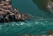
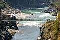
 Confluence of Alaknanda (bottom, from right) and Mandakini River (flowing from top - North) at Rudraprayag. Before 17 June 2013, there was a footbridge (jhula) over the Mandakini; this was washed away in the 2013 Uttarakhand floods. The stones at the bottom of the stairs were not there; instead, there was a viewing platform, and a large rock called Narad Shila. | |
 Rudraprayāga Location in Uttarakhand, India  Rudraprayāga Rudraprayāga (India) | |
| Coordinates: 30°17′N 78°59′E / 30.28°N 78.98°ECoordinates: 30°17′N 78°59′E / 30.28°N 78.98°E | |
| Country |
|
| State | Uttarakhand |
| District | Rudraprayag |
| Elevation | 895 m (2,936 ft) |
| Population (2001) | |
| • Total | 2,242 |
| Languages | |
| • Official | Hindi, Garhwali |
| Time zone | UTC+5:30 (IST) |
| Vehicle registration | UK 13 |
| Website |
rudraprayag |
Rudraprayag is a town and a municipality in Rudraprayag district in the Indian state of Uttarakhand. Rudraprayag is one of the Panch Prayag (five confluences) of Alaknanda River, the point of confluence of rivers Alaknanda and Mandakini. Kedarnath, a Hindu holy town is located 86 km from Rudraprayag. The man eating Leopard of Rudraprayag hunted and written about by Jim Corbett dwelled here.
Geography
Rudraprayag is located at 30°17′N 78°59′E / 30.28°N 78.98°E.[1] It has an average elevation of 895 metres (2,936 feet).
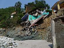
Many of the newer buildings and particularly the sangam (confluence) area was severely damaged in the 2013 Uttarakhand floods. A footbridge over the Mandakini river, and also a road bridge six km downstream at Raitoli was washed away. The layout of the sangam has altered significantly. The road along the Mandakini valley, leading to Kedarnath, was damaged at many points.
Demographics
2011 census population of rudraprayag city is 9,313 of which 5,240 are males while 4,073 are females. Female Sex Ratio of Rudraprayag is 777 against state average of 963. Moreover Child Sex Ratio in Rudraprayag is around 803 compared to Uttarakhand state average of 890. Literacy rate of Rudraprayag city is 89.42 % higher than state average of 78.82 %. In Rudraprayag, Male literacy is around 93.43 % while female literacy rate is 84.24 %.[2]
How to reach
Air
The nearest airport is the Jolly Grant Airport near Dehradun 183 km (114 mi) away.
Railway
The nearest railway station is at Rishikesh. However, Rishikesh is a small railway station not connected by fast trains. Haridwar railway junction, 24 km farther from Rishikesh, has train connections to most of the major cities in India and is, therefore, the railhead for Rudraprayag.
Road
Rudraprayag lies on national highway NH58 that connects Delhi with Badrinath and Mana Pass in Uttarakhand near Indo-Tibet border. Therefore, all the buses and vehicles that carry pilgrims from New Delhi to Badrinath via Haridwar and Rishikesh in pilgrim season of summer months pass through Rudraprayag on the way to Joshimath and further north. Rishikesh is a starting point for road journeys to Rudraprayag and regular buses operate from Rishikesh bus station to Rudraprayag. The road distance from Rishikesh to Rudraprayag is 141 km (88 mi) via Devprayag and Srinagar.
- Haridwar to Rishikesh 24 km
- Rishikesh to Devprayag 74 km
- Devprayag to Srinagar 34 km
- Srinagar to Rudraprayag 33 km
Places nearby
Rudranath Temple Rudraprayag is named after Lord Shiva and temple of lord Rudranath is situated at the confluence of Alaknanda and Mandakini. According to mythology Narada Muni worshiped god Shiva here to learn music from him. The god then taught him music in his form of Rudra (Lord of Music). There used to be a rock called Narad Shila where Narada is said to have sat in meditation.
Dhari Devi mandir is situated at Kalyasaur among Srinagar and Rudraprayag. Distance between Srinagar-Dhari Devi and Dhari Devi-Rudraprayag is 16 km and 20 km respectively. One can reach here with no trouble by taxi or bus from Srinagar and Rudraprayag.
Chamunda Devi Temple Chamunda Devi temple is also situated at confluence of the holy rivers ( Alaknanda & Mandakini). Chamunda as wife of Lord Rudra is worshiped here.
Koteshwar Koti means crore (10 Million) and Ishwar means god. This is again a temple of Lord Shiva made in natural caves.
Shree Tungeshwar Mahadev Ji, Phalasi (फलासी) Near Chopta This temple has been here for centuries. Folklore has it that the Pandavas came here for penance. On the way from Chopta there were many small temples up to the Tunganath Temple, the remains of some are still there. On the temple wall there are terracota style seals and Shiva-Parvati figurines.
Kartik Swami The Kartik Swami temple is dedicated to lord Kartikeya - son of Lord Shiva. It can be reached by a 3 km trek from Kanak Chauri village, which is located on the Rudraprayag-Pokhri route, 38 km from Rudraprayag. Visitors can see the snow-clad Himalayan range from the Kartik Swami temple.[3]
Basukedar Basukedar (reputedly where Shiva lived before coming to Kedarnath). It's a Shiva temple constructed by Pandava. Architecture and idols seems to be at least 1000 yrs old. A good place for meditation and dhyan yoga. This is around 35 km from Agustmuni. around 1.30 hr by drive. This is actually an old track to visit Kedarnath. It is said that Lord Shiva stayed a night in Basukedar while he was travelling to Mount Kailash ( Kedarnath) this is the reason this place is called Basukedar
Photo gallery (Images before June, 2013)
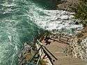 Confluence of the Alaknanda, left, and the Mandakini river, right, at Rudraprayag
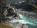 Confluence of Alaknanda (background) and Mandakini (foreground) at Rudraprayag. In the 2013 Uttarakhand floods, after the Mandakini ravaged its banks, all the structures below the Chamundi temple have been seriously damaged and the large boulder called Narad Shila has disappeared while a long line of stones have appeared along the confluence.
 Mandakini coming in to join Alaknanda. The jhula bridge seen here and the previous image was washed away along with the pillar on the other bankduring the 2013 Uttarakhand floods.
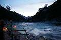 Evening prayers "Sandhya Aarti" at Rudraprayag
See also
References
- ↑ Falling Rain Genomics, Inc - Rudraprayag
- ↑ "Rudraprayag City Population Census 2011 - Uttarakhand". www.census2011.co.in. Retrieved 2018-09-13.
- ↑ Kartik Swami
External links
| Wikimedia Commons has media related to Rudraprayag. |