Dholpur
| Dholpur Dhaulpur | |
|---|---|
| City | |
 Chhatri of Rana Udaybhanu Singh at Dholpur | |
| Nickname(s): Dang | |
 Dholpur Location in Rajasthan, India | |
| Coordinates: 26°42′N 77°54′E / 26.7°N 77.9°ECoordinates: 26°42′N 77°54′E / 26.7°N 77.9°E | |
| Country |
|
| State | Rajasthan |
| Founded by | Dhaval Dev in 11th century |
| Area | |
| • City | 3,034 km2 (1,171 sq mi) |
| Elevation | 177 m (581 ft) |
| Population (2011)[1] | |
| • City | 126,142 |
| • Density | 42/km2 (110/sq mi) |
| • Metro[2] | 133,229 |
| Languages | |
| • Official | Hindi |
| Time zone | UTC+5:30 (IST) |
| PIN | 328001 |
| Telephone code | 05642 |
| Vehicle registration | RJ-11 |
| Sex ratio | 862 ♂/♀ |
| Website |
dholpur |

Dholpur is a city in eastern-most parts of the Rajasthan state of India. It is the administrative headquarters of Dholpur District and was formerly seat of the Dholpur princely state, before Independence.
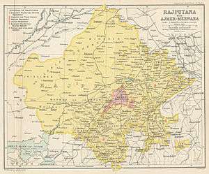
Dhaulpur became a separate district in 1982 comprising Dholpur, Rajakhera, Saramathura, Bari and Baseri Tehsils. Dholpur district is a part of Bharatpur Division/Commissionerate. It is bordered by Bharatpur district of Rajasthan and Uttar Pradesh to the north, Madhya Pradesh to the south, Karauli district to the west and Uttar Pradesh and Madhya Pradesh to the east.
Geography
The geographical coordinates for Dholpur (Dhaulpur) are 26° 42' 0" North, 77° 54' 0" East.[3] Total area of Dholpur district is 3,034 sq. km[4]
Tasimo History
Tasimo Ke Veer Shaheed
To liberate the country, many people sacrificed their lives for the country. Similarly, the names of martyrs of Tasimo village of Dholpur come as martyrs Chhatar Singh Parmar and Shaheed Pancham Singh Kushwah. Who sacrificed his life for the country. The important event in the history of Dholpur was on 11 April 1947 when the workers of the society gathered at Tasimo village gathering place. Then there was a ban on hoisting the flag, but the neem tree had a tricolor wave and the meeting was going on. At the same time, the Samajwadi police station Shamsher Singh, the Deputy Superintendent of Police, Gurudatt Singh, and the Thanedar Aliazam reached the meeting with the police at the meeting and when they came forward to bring the flag of the Tricolor, Thakur Chhattar Singh, who was present in the assembly, stood in front of the soldiers and Tricolor said in the condition of not releasing the flag. In that very same, the police shot Thakur Chhattar Singh. Then Pancham Singh Kushwaha came forward and the police shot him too. As soon as the two martyrs fell on the ground, the people present in the gathering surrounded the neem tree that had become a tricolor and said that the shoot shot is ready for us to die for Bharat Maata. And the shouting of the name of Bharat Maata, the police retreated, seeing the matter deteriorating. Due to this martyrdom of freedom fighters, Tasimo village was recorded not only in Rajasthan but in the entire history of India, which is known in history as 'Tasimo Goli Kand'. He, who did not care for his life, left his life for the Tricolor. Such were our heroes of Shaheed Chhattar Singh Parmar and Pancham Singh Kushvah of Dholpur. Pandit Roshanlal 83, who witnessed the incident, points out that the marks of bullets run by the police at the behest of the monarchy have not even blurred on their hands. The same witness, 86-year-old Jamunadas Mittal, said that for the shame of the Tricolor, two of his sons They are curious on martyrdom.
History
Tomar rule
Dholpur or Dhawalpuri was established in 700 AD by Raja Dholan Dev Tomar and most likely the name of city was changed to Dholpur after him. He resided 10 km south west of Dholpur at a place called Bilpur near chambal where a fort still exists.[5] His descendant Raja Dhawal Deo built the new town of Dholpur in 1050 AD. Their descendants are still living in the area and till independence were rulers of many small chieftainships in Morena and Gwalior. He was ruler of country between Chambal and Banganga. The Dholeshwar Mahadev Temple built by this Raja was washed away in Chambal floods of 1868 AD.[6] The Tomars lost sovereignty to Jadu's of Karauli.
Jadon rulers of Karauli
The Dholpur fort was built by Dharampal, Raja of Karauli in 1120 A.D.[6]
Mughal period
After the battle of Panipat, Babar became the first Mughal ruler of Hindustan. His rule was not a bed of roses in the early years of his reign. Dhaulpur was taken by Sikandar Lodhi in 1501, who handed it to a Muslim governor in 1504.After the death of Ibrahim Lodi, many states declared themselves independent. Talai Khan became the ruler of Gwalior. Similarly, Mohammed Jaifoon declared himself the ruler of Dholpur.
Bhadauria Rule
In 1527, Dhaulpur fort fell to Babur and continued to be ruled by the Mughals until 1707. After the death of the Mughal emperor Aurangzeb, Raja Kalyan Singh Bhadauria obtained possession of Dhaulpur, and his family retained it until 1761. After that, Dholpur was taken successively by the Jat ruler Maharaja Suraj Mal of Bharatpur; by Mirza Najaf Khan in 1775; by the Scindia ruler of Gwalior in 1782; and finally, by the British East India Company in 1803. It was restored by the British to the Scindias under the Treaty of Sarji Anjangaon, briefly, and was soon reoccupied by the British. In 1805, Dhaulpur came under the Jat ruler, Kirat Singh of Gohad, a princely state, a vassal of the British during the Raj. [7][8]
According to the Babur Nama, Babur had a baori built in Dholpur on his last trip to Gwalior, to add to the charghar ("four-gardens") he had already had built there.[9]
British rule and after
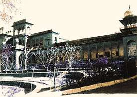
After Mughals Rana vansh of Jats become ruler of Dhaulpur, during British Raj, it was part of the Rajputana Agency, till the Independence of India. The former mansion of the ruler of the erstwhile Dholpur State, Kesarbagh palace, now houses the Dholpur Military School, while its official residence in New Delhi, Dholpur House, is used by the Union Public Service Commission.
Demographics
As of the 2011 census, Dhaulpur municipality had a population of 126,142[1] and the urban agglomeration had a population of 133,229.[2] The municipality had a sex ratio of 862 females per 1,000 males and 13.6% of the population were under six years old.[1] Effective literacy was 76.56%; male literacy was 84.22% and female literacy was 67.74%.[1]
Education
The notable Dholpur Military School is housed in Kesarbagh Palace, a magnificent mansion of the former ruler of the erstwhile Dholpur State. It is 10.5 kilometres away from Dholpur City and on Dholpur-Bari Road.
Climate
Dholpur is reputed to be the location of the highest recorded temperature in India, at 50 °C on 3 June 2017. The hottest months are May and June, which mark the oppressive summer season. Temperatures in summers are normally higher than 40 °C. Coldest months are December and January where temperatures sometimes reach near-zero and subzero levels. The lowest recorded temperature is -4.3 °C on 29 January 2017.[10]
| Climate data for Dholpur | |||||||||||||
|---|---|---|---|---|---|---|---|---|---|---|---|---|---|
| Month | Jan | Feb | Mar | Apr | May | Jun | Jul | Aug | Sep | Oct | Nov | Dec | Year |
| Record high °C (°F) | 32.6 (90.7) |
36.8 (98.2) |
42.8 (109) |
47.3 (117.1) |
49.8 (121.6) |
50.0 (122) |
46.0 (114.8) |
42.2 (108) |
41.7 (107.1) |
41.8 (107.2) |
37.7 (99.9) |
32.6 (90.7) |
50.0 (122) |
| Record low °C (°F) | −4.3 (24.3) |
0.2 (32.4) |
4.0 (39.2) |
11.0 (51.8) |
16.7 (62.1) |
18.4 (65.1) |
20.9 (69.6) |
17.4 (63.3) |
14.9 (58.8) |
8.9 (48) |
3.1 (37.6) |
−3.3 (26.1) |
−4.3 (24.3) |
| Source: India Meteorological Department[10] | |||||||||||||
See also
References
- 1 2 3 4 "Provisional Population Totals, Census of India 2011; Cities having population 1 lakh and above" (pdf). Office of the Registrar General & Census Commissioner, India. Retrieved 27 March 2012.
- 1 2 "Provisional Population Totals, Census of India 2011; Urban Agglomerations/Cities having population 1 lakh and above" (pdf). Office of the Registrar General & Census Commissioner, India. Retrieved 27 March 2012.
- ↑ Google. "maplandia.com". Google. Retrieved 10 October 2014.
- ↑ "Introduction". Archived from the original on 2005-08-29.
- ↑ John Murray (Firm), Edward Backhouse Eastwick -Handbook of the Bengal Presidency, page 370
- 1 2 John Murray (Firm), Edward Backhouse Eastwick - Handbook of the Bengal Presidency, page 370
- ↑ ""Dholpur: History and Places"".
- ↑ ""Dholpur online"".
- ↑ Babur Nama, Penguin, p. 311.
- 1 2 "Ever recorded Maximum and minimum temperatures upto 2010" (PDF). India Meteorological Department. Archived from the original (PDF) on 2013-05-21. Retrieved 2013-05-21.
External links
| Wikimedia Commons has media related to Dholpur. |
| Outline |  | ||||||||||||||
|---|---|---|---|---|---|---|---|---|---|---|---|---|---|---|---|
| Governance | |||||||||||||||
| Divisions and districts |
| ||||||||||||||
| Major cities | |||||||||||||||
| Related templates |
| ||||||||||||||