Colony Township, Greeley County, Kansas
| Colony Township | |
|---|---|
| Township | |
 Location in Greeley County | |
| Coordinates: 38°31′25″N 101°56′17″W / 38.52361°N 101.93806°WCoordinates: 38°31′25″N 101°56′17″W / 38.52361°N 101.93806°W | |
| Country | United States |
| State | Kansas |
| County | Greeley |
| Area | |
| • Total | 354.77 sq mi (918.86 km2) |
| • Land | 354.77 sq mi (918.86 km2) |
| • Water | 0 sq mi (0 km2) 0% |
| Elevation | 3,812 ft (1,162 m) |
| Population (2000) | |
| • Total | 172 |
| • Density | 0.5/sq mi (0.2/km2) |
| GNIS feature ID | 0485231 |
Colony Township was a township in Greeley County, Kansas, USA. As of the 2000 census, the population of the former township was 172.
Geography
Colony Township covered an area of 354.77 square miles (918.9 km2) and contained no incorporated settlements. According to the USGS, it contains two cemeteries: Mathews and Rogers.
The stream of South Fork White Woman Creek runs through this township.
Greeley County was previously divided into three townships. However, in 1992, Colony Township and Harrison Township were merged into Tribune Township, leaving only one township for the county. This was not reported to the U.S. census until 2006, thus the 2000 census did not reflect the merger, but the 2010 census did.[1]
Transportation
Colony Township contained two airports or landing strips: Tuttle Landing Field and Walter Airport.
References
- ↑ Kansas: 2010, Population and Housing unit Counts, pdf p. 21 (2012)
External links
Municipalities and communities of Greeley County, Kansas, United States | ||
|---|---|---|
| Cities | 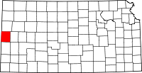 | |
| Unincorporated community | ||
| Townships | ||