Horace, Kansas
| Horace, Kansas | |
|---|---|
| City | |
 Location within Greeley County and Kansas | |
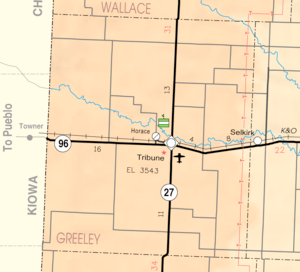 KDOT map of Greeley County (legend) | |
| Coordinates: 38°28′36″N 101°47′27″W / 38.47667°N 101.79083°WCoordinates: 38°28′36″N 101°47′27″W / 38.47667°N 101.79083°W | |
| Country | United States |
| State | Kansas |
| County | Greeley |
| Township | Tribune |
| Area[1] | |
| • Total | 0.25 sq mi (0.65 km2) |
| • Land | 0.25 sq mi (0.65 km2) |
| • Water | 0 sq mi (0 km2) |
| Elevation | 3,642 ft (1,110 m) |
| Population (2010)[2] | |
| • Total | 70 |
| • Estimate (2016)[3] | 72 |
| • Density | 280/sq mi (110/km2) |
| Time zone | UTC-7 (Mountain (MST)) |
| • Summer (DST) | UTC-6 (MDT) |
| Area code | 620 |
| FIPS code | 20-33150 [4] |
| GNIS ID | 0471490 [5] |
| Website | City Webpage |
Horace is a city in Greeley County, Kansas, United States. As of the 2010 census, the city population was 70.[6]
History
Horace was founded in 1886.[7] The city is named after Horace Greeley of Chappaqua, New York, editor of the New York Tribune.[8][9] Greeley encouraged western settlement with the motto "Go West, young man".[10]
A post office was opened in Horace in 1886, and remained in operation until it was discontinued in 1965.[11]
On November 6, 2007, voters in rural Greeley County and in Tribune approved a consolidation of the county and the city.[12] Horace, however, decided against consolidation.[13]
Geography
Horace is located at 38°28′36″N 101°47′27″W / 38.47667°N 101.79083°W (38.476692, -101.790853).[14] According to the United States Census Bureau, the city has a total area of 0.25 square miles (0.65 km2), all of it land.[1]
Demographics
| Historical population | |||
|---|---|---|---|
| Census | Pop. | %± | |
| 1890 | 150 | — | |
| 1900 | 90 | −40.0% | |
| 1910 | 189 | 110.0% | |
| 1920 | 212 | 12.2% | |
| 1930 | 230 | 8.5% | |
| 1940 | 234 | 1.7% | |
| 1950 | 258 | 10.3% | |
| 1960 | 195 | −24.4% | |
| 1970 | 137 | −29.7% | |
| 1980 | 137 | 0.0% | |
| 1990 | 168 | 22.6% | |
| 2000 | 143 | −14.9% | |
| 2010 | 70 | −51.0% | |
| Est. 2016 | 72 | [3] | 2.9% |
| U.S. Decennial Census | |||
2010 census
As of the census[2] of 2010, there were 70 people, 33 households, and 22 families residing in the city. The population density was 280.0 inhabitants per square mile (108.1/km2). There were 47 housing units at an average density of 188.0 per square mile (72.6/km2). The racial makeup of the city was 94.3% White, 2.9% African American, and 2.9% from two or more races. Hispanic or Latino of any race were 5.7% of the population.
There were 33 households of which 30.3% had children under the age of 18 living with them, 54.5% were married couples living together, 9.1% had a female householder with no husband present, 3.0% had a male householder with no wife present, and 33.3% were non-families. 33.3% of all households were made up of individuals and 3% had someone living alone who was 65 years of age or older. The average household size was 2.12 and the average family size was 2.68.
The median age in the city was 46.6 years. 22.9% of residents were under the age of 18; 4.2% were between the ages of 18 and 24; 15.7% were from 25 to 44; 41.5% were from 45 to 64; and 15.7% were 65 years of age or older. The gender makeup of the city was 47.1% male and 52.9% female.
2000 census
As of the census[4] of 2000, there were 143 people, 55 households, and 37 families residing in the city. The population density was 592.3 people per square mile (230.1/km²). There were 66 housing units at an average density of 273.4 per square mile (106.2/km²). The racial makeup of the city was 94.41% White, 0.70% African American, 2.80% from other races, and 2.10% from two or more races. Hispanic or Latino of any race were 15.38% of the population.
There were 55 households out of which 38.2% had children under the age of 18 living with them, 56.4% were married couples living together, 5.5% had a female householder with no husband present, and 32.7% were non-families. 29.1% of all households were made up of individuals and 5.5% had someone living alone who was 65 years of age or older. The average household size was 2.60 and the average family size was 3.22.
In the city, the population was spread out with 31.5% under the age of 18, 6.3% from 18 to 24, 36.4% from 25 to 44, 20.3% from 45 to 64, and 5.6% who were 65 years of age or older. The median age was 34 years. For every 100 females, there were 123.4 males. For every 100 females age 18 and over, there were 122.7 males.
The median income for a household in the city was $26,875, and the median income for a family was $43,125. Males had a median income of $30,625 versus $21,250 for females. The per capita income for the city was $15,602. There were 15.6% of families and 20.4% of the population living below the poverty line, including 25.5% of under eighteens and none of those over 64.
References
- 1 2 "US Gazetteer files 2010". United States Census Bureau. Archived from the original on 2012-01-24. Retrieved 2012-07-06.
- 1 2 "American FactFinder". United States Census Bureau. Retrieved 2012-07-06.
- 1 2 "Population and Housing Unit Estimates". Retrieved June 9, 2017.
- 1 2 "American FactFinder". United States Census Bureau. Retrieved 2008-01-31.
- ↑ "US Board on Geographic Names". United States Geological Survey. 2007-10-25. Retrieved 2008-01-31.
- ↑ "2010 City Population and Housing Occupancy Status". U.S. Census Bureau. Archived from the original on July 21, 2011. Retrieved August 31, 2011.
- ↑ Blackmar, Frank Wilson (1912). Kansas: A Cyclopedia of State History, Embracing Events, Institutions, Industries, Counties, Cities, Towns, Prominent Persons, Etc. Standard Publishing Company. p. 872.
- ↑ Gannett, Henry (1905). The Origin of Certain Place Names in the United States. Govt. Print. Off. p. 161.
- ↑ "Profile for Horace, Kansas". ePodunk. Retrieved 10 June 2014.
- ↑ Josiah Busnell Grinnell (1891). Men and Events of Forty Years. Boston: D. Lothrop. p. 87. Retrieved 2009-02-13.
- ↑ "Kansas Post Offices, 1828-1961". Kansas Historical Society. Retrieved 10 June 2014.
- ↑ Greeley County residents pass unification Archived 2009-03-21 at the Wayback Machine., Garden City Telegram, 2007-11-07. Accessed 2007-11-08.
- ↑ TRIBUNE | City and county to unify, The Kansas City Star, 2007-11-07. Accessed 2007-11-08.
- ↑ "US Gazetteer files: 2010, 2000, and 1990". United States Census Bureau. 2011-02-12. Retrieved 2011-04-23.
External links
| Wikimedia Commons has media related to Horace, Kansas. |
- City
- Schools
- USD 200, local school district
- Maps
- Horace City Map, KDOT
Municipalities and communities of Greeley County, Kansas, United States | ||
|---|---|---|
| Cities | 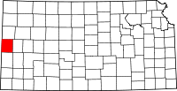 | |
| Unincorporated community | ||
| Townships | ||