Sainte-Gemme, Gers
| Sainte-Gemme | |
|---|---|
| Commune | |
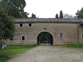 Entrance of the Château de Lauret | |
 Sainte-Gemme Location within Occitanie region  Sainte-Gemme | |
| Coordinates: 43°46′57″N 0°48′01″E / 43.7825°N 0.8003°ECoordinates: 43°46′57″N 0°48′01″E / 43.7825°N 0.8003°E | |
| Country | France |
| Region | Occitanie |
| Department | Gers |
| Arrondissement | Condom |
| Canton | Gimone-Arrats |
| Intercommunality | Bastides du Val d'Arrats |
| Government | |
| • Mayor (2008–2014) | Guy Robin |
| Area1 | 10.22 km2 (3.95 sq mi) |
| Population (2008)2 | 132 |
| • Density | 13/km2 (33/sq mi) |
| Time zone | UTC+1 (CET) |
| • Summer (DST) | UTC+2 (CEST) |
| INSEE/Postal code | 32376 /32120 |
| Elevation |
121–194 m (397–636 ft) (avg. 175 m or 574 ft) |
|
1 French Land Register data, which excludes lakes, ponds, glaciers > 1 km2 (0.386 sq mi or 247 acres) and river estuaries. 2 Population without double counting: residents of multiple communes (e.g., students and military personnel) only counted once. | |
Sainte-Gemme is a commune in the Gers department in southwestern France.
Geography
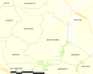
Sainte-Gemme and its surrounding communes
Population
| Historical population | ||
|---|---|---|
| Year | Pop. | ±% |
| 1962 | 141 | — |
| 1968 | 175 | +24.1% |
| 1975 | 142 | −18.9% |
| 1982 | 136 | −4.2% |
| 1990 | 118 | −13.2% |
| 1999 | 100 | −15.3% |
| 2008 | 132 | +32.0% |
See also
References
| Wikimedia Commons has media related to Sainte-Gemme (Gers). |
This article is issued from
Wikipedia.
The text is licensed under Creative Commons - Attribution - Sharealike.
Additional terms may apply for the media files.