La Romieu
| La Romieu | ||
|---|---|---|
| Commune | ||
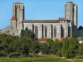 St. Peter's collegiate church | ||
| ||
 La Romieu Location within Occitanie region  La Romieu | ||
| Coordinates: 43°58′58″N 0°29′55″E / 43.9828°N 0.4986°ECoordinates: 43°58′58″N 0°29′55″E / 43.9828°N 0.4986°E | ||
| Country | France | |
| Region | Occitanie | |
| Department | Gers | |
| Arrondissement | Condom | |
| Canton | Lectoure-Lomagne | |
| Intercommunality | Lomagne Gersoise | |
| Government | ||
| • Mayor (2008–2014) | Denis Delouse | |
| Area1 | 27.48 km2 (10.61 sq mi) | |
| Population (2008)2 | 535 | |
| • Density | 19/km2 (50/sq mi) | |
| Time zone | UTC+1 (CET) | |
| • Summer (DST) | UTC+2 (CEST) | |
| INSEE/Postal code | 32345 /32480 | |
| Elevation |
104–217 m (341–712 ft) (avg. 187 m or 614 ft) | |
|
1 French Land Register data, which excludes lakes, ponds, glaciers > 1 km2 (0.386 sq mi or 247 acres) and river estuaries. 2 Population without double counting: residents of multiple communes (e.g., students and military personnel) only counted once. | ||
.svg.png)
La Romieu is a commune in the Gers department in southwestern France.
It is known for its magnificent Collégiale St. Pierre, a 14th-century cloister with a tower.
Geography
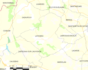
La Romieu and its surrounding communes
Population
| Historical population | ||
|---|---|---|
| Year | Pop. | ±% |
| 1962 | 688 | — |
| 1968 | 644 | −6.4% |
| 1975 | 535 | −16.9% |
| 1982 | 547 | +2.2% |
| 1990 | 528 | −3.5% |
| 1999 | 532 | +0.8% |
| 2008 | 535 | +0.6% |
Sights
See also
References
| Wikimedia Commons has media related to La Romieu. |
This article is issued from
Wikipedia.
The text is licensed under Creative Commons - Attribution - Sharealike.
Additional terms may apply for the media files.