Saramon
| Saramon | ||
|---|---|---|
| Commune | ||
_%C3%89glise_03.JPG) | ||
| ||
 Saramon Location within Occitanie region  Saramon | ||
| Coordinates: 43°31′25″N 0°45′54″E / 43.5236°N 0.765°ECoordinates: 43°31′25″N 0°45′54″E / 43.5236°N 0.765°E | ||
| Country | France | |
| Region | Occitanie | |
| Department | Gers | |
| Arrondissement | Auch | |
| Canton | Astarac-Gimone | |
| Intercommunality | Coteaux de Gimone | |
| Government | ||
| • Mayor (2008–2014) | Jean-Pierre Salers | |
| Area1 | 13.03 km2 (5.03 sq mi) | |
| Population (2008)2 | 782 | |
| • Density | 60/km2 (160/sq mi) | |
| Time zone | UTC+1 (CET) | |
| • Summer (DST) | UTC+2 (CEST) | |
| INSEE/Postal code | 32412 /32450 | |
| Elevation |
166–266 m (545–873 ft) (avg. 200 m or 660 ft) | |
|
1 French Land Register data, which excludes lakes, ponds, glaciers > 1 km2 (0.386 sq mi or 247 acres) and river estuaries. 2 Population without double counting: residents of multiple communes (e.g., students and military personnel) only counted once. | ||
.svg.png)
Saramon is a commune in the Gers department in southwestern France.
Geography
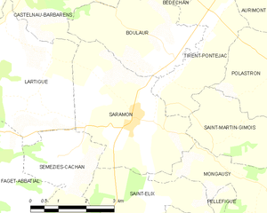
Saramon and its surrounding communes
Population
| Historical population | ||
|---|---|---|
| Year | Pop. | ±% |
| 1841 | 1,276 | — |
| 1876 | 1,241 | −2.7% |
| 1793 | 956 | −23.0% |
| 1846 | 1,174 | +22.8% |
| 1881 | 1,240 | +5.6% |
| 1800 | 941 | −24.1% |
| 1851 | 1,283 | +36.3% |
| 1886 | 1,232 | −4.0% |
| 1806 | 1,054 | −14.4% |
| 1856 | 1,260 | +19.5% |
| 1891 | 1,220 | −3.2% |
| 1821 | 1,116 | −8.5% |
| 1861 | 1,299 | +16.4% |
| 1896 | 1,123 | −13.5% |
| 1831 | 1,216 | +8.3% |
| 1866 | 1,318 | +8.4% |
| 1872 | 1,204 | −8.6% |
| 1911 | 974 | −19.1% |
| 1921 | 819 | −15.9% |
| 1926 | 806 | −1.6% |
| 1931 | 829 | +2.9% |
| 1936 | 797 | −3.9% |
| 1901 | 984 | +23.5% |
| 1906 | 996 | +1.2% |
| 1946 | 767 | −23.0% |
| 1954 | 740 | −3.5% |
| 1962 | 742 | +0.3% |
| 1968 | 779 | +5.0% |
| 1975 | 759 | −2.6% |
| 1982 | 717 | −5.5% |
| 1990 | 661 | −7.8% |
| 1999 | 673 | +1.8% |
| 2008 | 782 | +16.2% |
See also
References
| Wikimedia Commons has media related to Saramon. |
This article is issued from
Wikipedia.
The text is licensed under Creative Commons - Attribution - Sharealike.
Additional terms may apply for the media files.