Endoufielle
| Endoufielle | ||
|---|---|---|
| Commune | ||
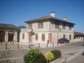 Town hall | ||
| ||
 Endoufielle Location within Occitanie region  Endoufielle | ||
| Coordinates: 43°33′07″N 1°01′27″E / 43.5519°N 1.0242°ECoordinates: 43°33′07″N 1°01′27″E / 43.5519°N 1.0242°E | ||
| Country | France | |
| Region | Occitanie | |
| Department | Gers | |
| Arrondissement | Auch | |
| Canton | L'Isle-Jourdain | |
| Intercommunality | Save Lisloise | |
| Government | ||
| • Mayor (2008–2014) | Michelle Lannes | |
| Area1 | 17.1 km2 (6.6 sq mi) | |
| Population (2008)2 | 551 | |
| • Density | 32/km2 (83/sq mi) | |
| Time zone | UTC+1 (CET) | |
| • Summer (DST) | UTC+2 (CEST) | |
| INSEE/Postal code | 32121 /32600 | |
| Elevation |
146–235 m (479–771 ft) (avg. 218 m or 715 ft) | |
|
1 French Land Register data, which excludes lakes, ponds, glaciers > 1 km2 (0.386 sq mi or 247 acres) and river estuaries. 2 Population without double counting: residents of multiple communes (e.g., students and military personnel) only counted once. | ||
.svg.png)
Endoufielle is a commune in the Gers department in southwestern France.
Geography
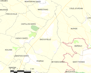
Endoufielle and its surrounding communes
Population
| Historical population | ||
|---|---|---|
| Year | Pop. | ±% |
| 1962 | 294 | — |
| 1968 | 348 | +18.4% |
| 1975 | 310 | −10.9% |
| 1982 | 312 | +0.6% |
| 1990 | 397 | +27.2% |
| 1999 | 446 | +12.3% |
| 2008 | 551 | +23.5% |
See also
References
| Wikimedia Commons has media related to Endoufielle. |
This article is issued from
Wikipedia.
The text is licensed under Creative Commons - Attribution - Sharealike.
Additional terms may apply for the media files.