Monbardon
| Monbardon | |
|---|---|
| Commune | |
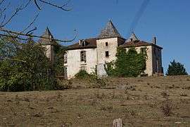 The castle | |
 Monbardon Location within Occitanie region  Monbardon | |
| Coordinates: 43°22′57″N 0°42′36″E / 43.3825°N 0.71°ECoordinates: 43°22′57″N 0°42′36″E / 43.3825°N 0.71°E | |
| Country | France |
| Region | Occitanie |
| Department | Gers |
| Arrondissement | Mirande |
| Canton | Astarac-Gimone |
| Intercommunality | Hautes Vallées |
| Government | |
| • Mayor (2008–2014) | Francis Roudeau |
| Area1 | 6.41 km2 (2.47 sq mi) |
| Population (2008)2 | 90 |
| • Density | 14/km2 (36/sq mi) |
| Time zone | UTC+1 (CET) |
| • Summer (DST) | UTC+2 (CEST) |
| INSEE/Postal code | 32260 /32420 |
| Elevation |
216–316 m (709–1,037 ft) (avg. 275 m or 902 ft) |
|
1 French Land Register data, which excludes lakes, ponds, glaciers > 1 km2 (0.386 sq mi or 247 acres) and river estuaries. 2 Population without double counting: residents of multiple communes (e.g., students and military personnel) only counted once. | |
Monbardon is a commune in the Gers department in southwestern France.
Geography
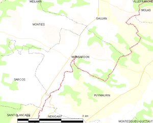
Monbardon and its surrounding communes
Population
| Historical population | ||
|---|---|---|
| Year | Pop. | ±% |
| 1962 | 86 | — |
| 1968 | 103 | +19.8% |
| 1975 | 104 | +1.0% |
| 1982 | 103 | −1.0% |
| 1990 | 104 | +1.0% |
| 1999 | 88 | −15.4% |
| 2008 | 90 | +2.3% |
See also
References
| Wikimedia Commons has media related to Monbardon. |
This article is issued from
Wikipedia.
The text is licensed under Creative Commons - Attribution - Sharealike.
Additional terms may apply for the media files.