Solomiac
| Solomiac | |
|---|---|
| Commune | |
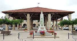 War memorial and market hall | |
 Solomiac Location within Occitanie region  Solomiac | |
| Coordinates: 43°48′23″N 0°53′54″E / 43.8064°N 0.8983°ECoordinates: 43°48′23″N 0°53′54″E / 43.8064°N 0.8983°E | |
| Country | France |
| Region | Occitanie |
| Department | Gers |
| Arrondissement | Condom |
| Canton | Gimone-Arrats |
| Intercommunality | Bastides du Val d'Arrats |
| Government | |
| • Mayor (2008–2014) | Guy Mantovani |
| Area1 | 13.8 km2 (5.3 sq mi) |
| Population (2008)2 | 418 |
| • Density | 30/km2 (78/sq mi) |
| Time zone | UTC+1 (CET) |
| • Summer (DST) | UTC+2 (CEST) |
| INSEE/Postal code | 32436 /32120 |
| Elevation |
115–202 m (377–663 ft) (avg. 113 m or 371 ft) |
|
1 French Land Register data, which excludes lakes, ponds, glaciers > 1 km2 (0.386 sq mi or 247 acres) and river estuaries. 2 Population without double counting: residents of multiple communes (e.g., students and military personnel) only counted once. | |
Solomiac is a commune in the Gers department in southwestern France.
Geography
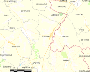
Solomiac and its surrounding communes
History
Solomiac was founded in 1322, by the Planselve Abbey, the Cistercian monastery, which was active from 1143 until 1789 and Beraud, the Seneschal of Solomiac.
Structure
This Bastide has the typical central market square with the halle, the market building in the center of this open space. The market building is built with stone with wooden and stone pillars on the roof. Around this area there are the typical stone houses with the arcades. At the top of the square, where is a church.
Population
| Historical population | ||
|---|---|---|
| Year | Pop. | ±% |
| 1962 | 519 | — |
| 1968 | 505 | −2.7% |
| 1975 | 446 | −11.7% |
| 1982 | 391 | −12.3% |
| 1990 | 363 | −7.2% |
| 1999 | 364 | +0.3% |
| 2008 | 418 | +14.8% |
See also
- Communes of the Gers department
- "Select Solomiac, at All Bastides". John Reps Collection. Cornell University Library.
References
| Wikimedia Commons has media related to Solomiac. |
| Authority control |
|---|
This article is issued from
Wikipedia.
The text is licensed under Creative Commons - Attribution - Sharealike.
Additional terms may apply for the media files.