Aubiet
| Aubiet | ||
|---|---|---|
| Commune | ||
 | ||
| ||
 Aubiet Location within Occitanie region  Aubiet | ||
| Coordinates: 43°38′49″N 0°47′04″E / 43.6469°N 0.7844°ECoordinates: 43°38′49″N 0°47′04″E / 43.6469°N 0.7844°E | ||
| Country | France | |
| Region | Occitanie | |
| Department | Gers | |
| Arrondissement | Auch | |
| Canton | Auch-2 | |
| Intercommunality | CC Coteaux Arrats Gimone | |
| Government | ||
| • Mayor (2014-2020) | Thierry Lecarpentier | |
| Area1 | 38.96 km2 (15.04 sq mi) | |
| Population (2015)2 | 1,102 | |
| • Density | 28/km2 (73/sq mi) | |
| Time zone | UTC+1 (CET) | |
| • Summer (DST) | UTC+2 (CEST) | |
| INSEE/Postal code | 32012 /32270 | |
| Elevation |
138–233 m (453–764 ft) (avg. 150 m or 490 ft) | |
|
1 French Land Register data, which excludes lakes, ponds, glaciers > 1 km2 (0.386 sq mi or 247 acres) and river estuaries. 2 Population without double counting: residents of multiple communes (e.g., students and military personnel) only counted once. | ||
.svg.png)
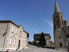
Aubiet is a commune in the Gers department in southwestern France.
Geography
Localisation
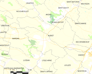
Aubiet and its surrounding communes
Roads and transports
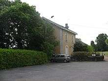
The train station in Aubiet
National road 124, which goes from Toulouse to Auch, passes by Aubiet.
Aubiet has a train station.
Population
| Historical population | ||
|---|---|---|
| Year | Pop. | ±% |
| 1962 | 960 | — |
| 1968 | 971 | +1.1% |
| 1975 | 880 | −9.4% |
| 1982 | 911 | +3.5% |
| 1990 | 1,019 | +11.9% |
| 1999 | 1,001 | −1.8% |
| 2008 | 1,099 | +9.8% |
| 2015 | 1,102 | +0.3% |
See also
References
| Wikimedia Commons has media related to Aubiet. |
This article is issued from
Wikipedia.
The text is licensed under Creative Commons - Attribution - Sharealike.
Additional terms may apply for the media files.