Plaisance, Gers
| Plaisance (Plasença) | ||
|---|---|---|
| Commune | ||
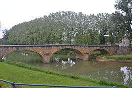 The bridge on the river Arros | ||
| ||
 Plaisance (Plasença) Location within Occitanie region  Plaisance (Plasença) | ||
| Coordinates: 43°36′24″N 0°02′50″E / 43.6067°N 0.0472°ECoordinates: 43°36′24″N 0°02′50″E / 43.6067°N 0.0472°E | ||
| Country | France | |
| Region | Occitanie | |
| Department | Gers | |
| Arrondissement | Mirande | |
| Canton | Pardiac-Rivière-Basse | |
| Intercommunality | Bastides et vallons du Gers | |
| Government | ||
| • Mayor (2008–2014) | Régis Soubabère | |
| Area1 | 13.71 km2 (5.29 sq mi) | |
| Population (2012)2 | 1,475 | |
| • Density | 110/km2 (280/sq mi) | |
| Time zone | UTC+1 (CET) | |
| • Summer (DST) | UTC+2 (CEST) | |
| INSEE/Postal code | 32319 /32160 | |
| Elevation |
122–186 m (400–610 ft) (avg. 131 m or 430 ft) | |
|
1 French Land Register data, which excludes lakes, ponds, glaciers > 1 km2 (0.386 sq mi or 247 acres) and river estuaries. 2 Population without double counting: residents of multiple communes (e.g., students and military personnel) only counted once. | ||
.svg.png)
Plaisance (Gascon: Plasença) is a commune in the Gers department in southwestern France.
Geography
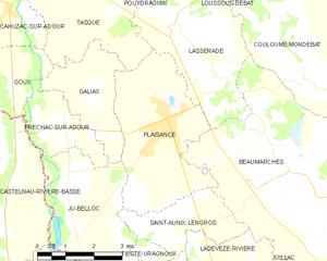
Plaisance and its surrounding communes
Population
| Historical population | ||
|---|---|---|
| Year | Pop. | ±% |
| 1962 | 1,490 | — |
| 1968 | 1,535 | +3.0% |
| 1975 | 1,576 | +2.7% |
| 1982 | 1,575 | −0.1% |
| 1990 | 1,657 | +5.2% |
| 1999 | 1,479 | −10.7% |
| 2008 | 1,465 | −0.9% |
| 2012 | 1,475 | +0.7% |
See also
References
| Wikimedia Commons has media related to Plaisance (Gers). |
This article is issued from
Wikipedia.
The text is licensed under Creative Commons - Attribution - Sharealike.
Additional terms may apply for the media files.