Espas
| Espas | |
|---|---|
| Commune | |
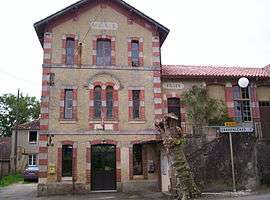 Town hall | |
 Espas Location within Occitanie region  Espas | |
| Coordinates: 43°46′55″N 0°04′17″E / 43.7819°N 0.0714°ECoordinates: 43°46′55″N 0°04′17″E / 43.7819°N 0.0714°E | |
| Country | France |
| Region | Occitanie |
| Department | Gers |
| Arrondissement | Condom |
| Canton | Grand-Bas-Armagnac |
| Government | |
| • Mayor (2008–2014) | Pierre Cazères |
| Area1 | 15.13 km2 (5.84 sq mi) |
| Population (2008)2 | 115 |
| • Density | 7.6/km2 (20/sq mi) |
| Time zone | UTC+1 (CET) |
| • Summer (DST) | UTC+2 (CEST) |
| INSEE/Postal code | 32125 /32370 |
| Elevation |
119–221 m (390–725 ft) (avg. 217 m or 712 ft) |
|
1 French Land Register data, which excludes lakes, ponds, glaciers > 1 km2 (0.386 sq mi or 247 acres) and river estuaries. 2 Population without double counting: residents of multiple communes (e.g., students and military personnel) only counted once. | |
Espas is a commune in the Gers department in southwestern France.
Geography
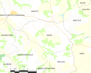
Espas and its surrounding communes
Population
| Historical population | ||
|---|---|---|
| Year | Pop. | ±% |
| 1962 | 231 | — |
| 1968 | 188 | −18.6% |
| 1975 | 183 | −2.7% |
| 1982 | 151 | −17.5% |
| 1990 | 132 | −12.6% |
| 1999 | 124 | −6.1% |
| 2008 | 115 | −7.3% |
See also
References
| Wikimedia Commons has media related to Espas. |
This article is issued from
Wikipedia.
The text is licensed under Creative Commons - Attribution - Sharealike.
Additional terms may apply for the media files.