Masseube
| Masseube | ||
|---|---|---|
| Commune | ||
 | ||
| ||
 Masseube Location within Occitanie region  Masseube | ||
| Coordinates: 43°25′51″N 0°34′47″E / 43.430833°N 0.579722°ECoordinates: 43°25′51″N 0°34′47″E / 43.430833°N 0.579722°E | ||
| Country | France | |
| Region | Occitanie | |
| Department | Gers | |
| Arrondissement | Mirande | |
| Canton | Astarac-Gimone | |
| Intercommunality | Val de Gers | |
| Government | ||
| • Mayor (2008–2014) | Jean-Pierre Bru | |
| Area1 | 21.03 km2 (8.12 sq mi) | |
| Population (2012)2 | 1,532 | |
| • Density | 73/km2 (190/sq mi) | |
| Time zone | UTC+1 (CET) | |
| • Summer (DST) | UTC+2 (CEST) | |
| INSEE/Postal code | 32242 /32140 | |
| Elevation |
188–306 m (617–1,004 ft) (avg. 200 m or 660 ft) | |
|
1 French Land Register data, which excludes lakes, ponds, glaciers > 1 km2 (0.386 sq mi or 247 acres) and river estuaries. 2 Population without double counting: residents of multiple communes (e.g., students and military personnel) only counted once. | ||
.svg.png)
Masseube (Masseuva in Gascon) is a commune in the Gers department in the Occitanie region in southwestern France.
Geography
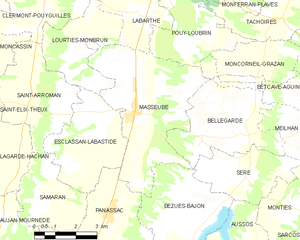
Masseube and its surrounding communes
History
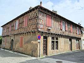
Masseube ("The farmhouse of the forest") was originally the name of a farm belonging to Escaladieu Abbey, in Bigorre. In 1274, the Abbey and Bernard IV of Astarac founded a Bastide in Masseube. It got its customary laws 2 years later. The bastide still has its streets at right angles, an old on the common house which is now the Mairie, and houses built with timber.
Population
Its inhabitants are called Massylvains
| Historical population | ||
|---|---|---|
| Year | Pop. | ±% |
| 1793 | 1,336 | — |
| 1800 | 1,294 | −3.1% |
| 1806 | 1,455 | +12.4% |
| 1821 | 1,447 | −0.5% |
| 1831 | 1,640 | +13.3% |
| 1841 | 1,806 | +10.1% |
| 1846 | 1,776 | −1.7% |
| 1851 | 1,760 | −0.9% |
| 1856 | 1,781 | +1.2% |
| 1861 | 1,682 | −5.6% |
| 1866 | 1,804 | +7.3% |
| 1872 | 1,769 | −1.9% |
| 1876 | 1,765 | −0.2% |
| 1881 | 1,720 | −2.5% |
| 1886 | 1,757 | +2.2% |
| 1891 | 1,614 | −8.1% |
| 1896 | 1,511 | −6.4% |
| 1901 | 1,502 | −0.6% |
| 1906 | 1,456 | −3.1% |
| 1911 | 1,431 | −1.7% |
| 1921 | 1,146 | −19.9% |
| 1926 | 1,177 | +2.7% |
| 1931 | 1,153 | −2.0% |
| 1936 | 1,147 | −0.5% |
| 1946 | 1,357 | +18.3% |
| 1954 | 1,242 | −8.5% |
| 1962 | 1,230 | −1.0% |
| 1968 | 1,316 | +7.0% |
| 1975 | 1,309 | −0.5% |
| 1982 | 1,376 | +5.1% |
| 1990 | 1,453 | +5.6% |
| 1999 | 1,391 | −4.3% |
| 2008 | 1,594 | +14.6% |
| 2012 | 1,532 | −3.9% |
Sites of interest
- Église Saint-Christophe, originally from the 13th Century c., was reconstructed in 1700; it was again rebuilt in 1883 when it was threatening to topple. The only conserved pieces are the lower part of the façade and the tower. The rest was reconstructed in the style of the 13th Century. In 1932-33, in honor of the 50th year after the renovation, Paul Noël Lasseran was called to paint murals. He finished a majority of them before his death in 1933.
- Rue Lagrange: This road is spanned by a cover which connects to buildings which were originally agricultural.
Notable people
- Jean-Marie Ducos: Deputy of Gers and member of the First French Parliament from 1798-99.
Heraldry
The coat of arms was changed in 2009.[1]
See also
References
| Wikimedia Commons has media related to Masseube. |
- ↑ "Archived copy". Archived from the original on 2013-05-15. Retrieved 2013-06-06.
This article is issued from
Wikipedia.
The text is licensed under Creative Commons - Attribution - Sharealike.
Additional terms may apply for the media files.